
Page 46: of Offshore Engineer Magazine (Jun/Jul 2013)
Read this page in Pdf, Flash or Html5 edition of Jun/Jul 2013 Offshore Engineer Magazine
 45
45
 47
47
(20%); and Russian state-owned Rosneft subsidiaries Sakhalinmorneftegas-Shelf (11.5%); and RN-Astra (8.5%).
The frst phase of Sakhalin-1 devel- opment started in 2002 and included
Organizing extended-reach wells drilled from the land-based, 70m-tall drilling rig, Offshore Russia
Yastreb, meaning “hawk.” The rig was the weather designed to withstand earthquakes and arctic conditions. The Chayvo feld was developed frst, using the Yastreb rig off Sakhalin and the Orlan rig on the Orlan platform, a concrete island drilling structure just administrative center of the Sakhalin of the coast from the Chayvo wellsite.
By Nina Rach ther than economics, logisti- Oblast (one of 46 oblasts in Russia), Production from Chayvo began in cal planning is the heart of any and runs the Kuril Islands. The city October 2005, with 50Mbo/d.
major project. Weather can have was founded in 1882, but the mod- Following the Chayvo drilling, ENL
O a signifcant impact on project suc- ern infrastructure is from oil and gas moved the Yastreb rig north to drill cess or failure, and while it can’t be development on the Sakhalin shelf. the Odoptu feld in 2008, and drilling controlled, it can be managed, even in there began in 2009, followed by frst a relatively remote location. Sakhalin-1 background production in 2010.
The operating conditions off 950-km
Sakhalin-1 is a consortium that pro- long Sakhalin Island include severe Weather, seismicity duces oil and gas from three sub-Arctic wave, wind, and earthquake activity Perhaps unfairly known for hostile felds off the northeast coast of Sakhalin: year-round and pack ice 1-1.5m (3-5ft) conditions, the weather in Sakhalin is
Chayvo, Odoptu, and Arkutun-Dagi. The thick for half the year. cold and humid, with average rainfall consortium is managed and operated by
To overcome these “daunting between 600-1200mm (23-47 in.), win-
Exxon Neftegas Ltd. (ENL), a subsid- weather-related barriers,” Exxon ter temperatures between -24°C (-11°F) iary of Exxon Mobil Corp. Partners
Neftegas Limited (ENL), a subsidiary and 10°C (50°F), and summer tempera- in Sakhalin-1 include Exxon Mobil of Exxon Mobil Corp. and operator of tures usually below 13-15°C (55-59°F). (30%); Japan’s Sakhalin Oil and Gas the Sakhalin-1 project, used on-site Temperatures fuctuate with mon-
Development Co. Ltd. (Sodeco; 30%); meteorologists for the 2012 offshore soonal circulation and the Sea of
Indian state-owned ONGC Videsh Ltd. (ice-free) season.
Setting
Sakhalin Island, off the east coast of
Russia, is situated between 54° 42’N latitude at its northernmost point, Cape
Elizabeth, and 45° 54’N latitude at its southernmost point, Cape Crillon.
Hokkaido, Japan’s northernmost island, is separated from Sakhalin Island by only 40km across the La Pérouse Strait.
Also known as the Soya Strait, this international waterway connects the
Sea of Okhotsk with the Sea of Japan.
The Sea of Okhotsk borders the east coast of Sakhalin Island, but it is sepa- rated from the Pacifc Ocean by the Kuril
Islands, which stretch northeast from the east coast of Hokkaido to the southern tip of the Kamchatka Peninsula.
The west coast of Sakhalin Island is separated from mainland Russia by the
Tartar Strait, which narrows to only 7.3km across the Nevelskoy Strait.
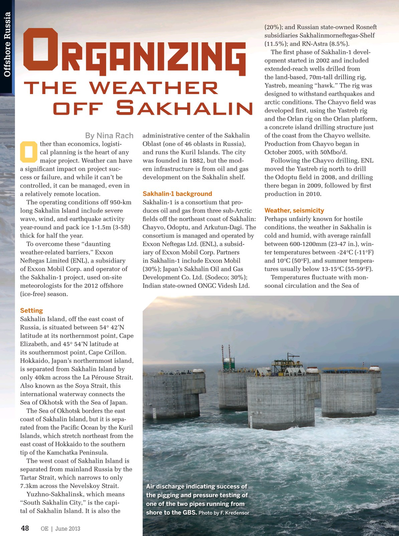
Air discharge indicating success of
Yuzhno-Sakhalinsk, which means the pigging and pressure testing of “South Sakhalin City,” is the capi- one of the two pipes running from tal of Sakhalin Island. It is also the
Photo by F. Kredensor shore to the GBS.
OE | June 2013 oedigital.com 48
Russia2-Sakhalin.indd 48 5/29/13 4:11 PM