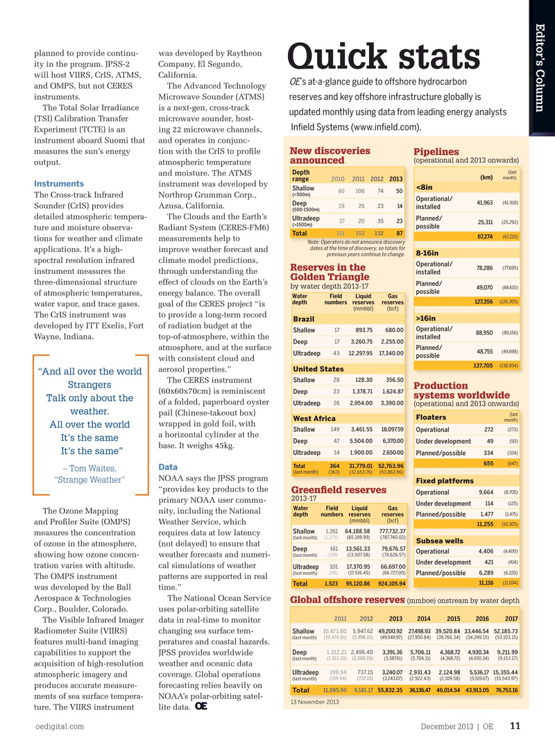
Page 9: of Offshore Engineer Magazine (Dec/Jan 2013)
Read this page in Pdf, Flash or Html5 edition of Dec/Jan 2013 Offshore Engineer Magazine
Editor’s Column planned to provide continu- was developed by Raytheon ity in the program. JPSS-2 Company, El Segundo,
Quick stats will host VIIRS, CrIS, ATMS, California.
OE ’s at-a-glance guide to ofshore hydrocarbon and OMPS, but not CERES The Advanced Technology instruments. Microwave Sounder (ATMS) reserves and key ofshore infrastructure globally is
The Total Solar Irradiance is a next-gen, cross-track updated monthly using data from leading energy analysts (TSI) Calibration Transfer microwave sounder, host- Infeld Systems (www.infeld.com).
Experiment (TCTE) is an ing 22 microwave channels, instrument aboard Suomi that and operates in conjunc- measures the sun’s energy tion with the CrIS to profle
New discoveries Pipelines (operational and 2013 onwards) announced output. atmospheric temperature (last
Depth and moisture. The ATMS month) (km) range 2010 2011 2012 2013
Instruments instrument was developed by <8in
Shallow 86 106 74 50 (<500m)
The Cross-track Infrared Northrop Grumman Corp.,
Operational/ (41,918) 41,963
Deep 28 26 23 14
Sounder (CrIS) provides Azusa, California.
installed (500-1500m) detailed atmospheric tempera- The Clouds and the Earth’s
Ultradeep Planned/ 37 20 35 23 (25,292) 25,311 (>1500m) possible ture and moisture observa- Radiant System (CERES-FM6) 151 152 132 87
Total (67,210) 67,274 tions for weather and climate measurements help to
Note: Operators do not announce discovery dates at the time of discovery, so totals for applications. It’s a high- improve weather forecast and 8-16in previous years continue to change.
spectral resolution infrared climate model predictions,
Operational/ (77,695) 78,286
Reserves in the instrument measures the through understanding the installed
Golden Triangle three-dimensional structure effect of clouds on the Earth’s
Planned/ by water depth 2013-17 (48,610) 49,070 possible of atmospheric temperatures, energy balance. The overall
Water Field Liquid Gas (126,305) 127,356 depth numbers reserves reserves water vapor, and trace gases. goal of the CERES project “is (mmbbl) (bcf)
The CrIS instrument was to provide a long-term record >16in
Brazil developed by ITT Exelis, Fort of radiation budget at the
Operational/ 17 893.75 680.00
Shallow (89,156) 88,950 installed
Wayne, Indiana. top-of-atmosphere, within the
Deep 17 3,260.75 2,255.00
Planned/ atmosphere, and at the surface (49,698) 48,755 43 12,297.95 17,340.00
Ultradeep possible with consistent cloud and (138,854) 137,705
United States aerosol properties.” “And all over the world 28 128.30 356.50
Shallow
The CERES instrument
Strangers
Production 23 1,378.71 1,624.87 (60x60x70cm) is reminiscent
Deep systems worldwide
Talk only about the of a folded, paperboard oyster 26 2,954.00 3,390.00
Ultradeep (operational and 2013 onwards) weather. pail (Chinese-takeout box) (last
Floaters
West Africa month) wrapped in gold foil, with
All over the world (273) 149 3,461.55 18,097.59 272
Shallow Operational a horizontal cylinder at the
It’s the same (50) 47 5,504.00 6,370.00 49
Deep Under development base. It weighs 45kg.
It’s the same” 14 1,900.00 2,650.00 334 (324)
Ultradeep Planned/possible (647) 655
Total 364 31,779.01 52,763.96
Data – Tom Waites, (last month) (363) (32,653.76) (53,863.96)
NOAA says the JPSS program “Strange Weather”
Fixed platforms “provides key products to the
Greenfeld reserves (8,705) 9,664
Operational 2013-17 primary NOAA user commu- (125) 114
Under development
Water Field Liquid Gas
The Ozone Mapping nity, including the National (1,475) 1,477 depth numbers reserves reserves
Planned/possible (mmbbl) (bcf) and Profler Suite (OMPS) Weather Service, which (10,305) 11,255 64,188.58 777,732.371,261
Shallow measures the concentration requires data at low latency (last month) (1,275) (65,189.99) (787,740.02)
Subsea wells of ozone in the atmosphere, (not delayed) to ensure that
Deep 161 13,561.33 79,676.57 (4,400) 4,406
Operational (last month) (159) (13,507.58) (79,626.57) showing how ozone concen- weather forecasts and numeri- (414) 421
Under development tration varies with altitude. cal simulations of weather 101 17,370.95 66,697.00
Ultradeep (last month) (98) (17,516.45) (66,727.00) (6,220) 6,289
Planned/possible
The OMPS instrument patterns are supported in real (11,034) 11,116 1,523 95,120.86 924,105.94
Total was developed by the Ball time.”
Aerospace & Technologies The National Ocean Service
Global offshore reserves (mmboe) onstream by water depth
Corp., Boulder, Colorado. uses polar-orbiting satellite 2011 2012 201320142015 20162017
The Visible Infrared Imager data in real-time to monitor 5,947.62 10,473.80 49,200.92 27,498.93 39,520.84 33,446.54 52,185.73
Radiometer Suite (VIIRS) changing sea surface tem-
Shallow (last month) (10,474.81) (5,998.15) (49,549.97) (27,950.84) (39,766.34) (34,249.15) (53,103.15) features multi-band imaging peratures and coastal hazards.
Deep 1,312.21 2,496.40 3,391.36 5,706.11 4,368.72 4,930.34 9,211.99 capabilities to support the JPSS provides worldwide (last month) (1,312.21) (2,500.15) (3,387.61) (5,706.11) (4,368.72) (4,930.34) (9,153.17) acquisition of high-resolution weather and oceanic data 199.94 737.15 3,240.07 2,931.43 2,124.98 5,536.17 15,355.44
Ultradeep atmospheric imagery and coverage. Global operations (last month) (199.94) (737.15) (3,243.07) (2,922.43) (2,109.58) (5,519.67) (15,543.97) produces accurate measure- forecasting relies heavily on 11,985.95 9,181.17 55,832.35 36,136.47 46,014.54 43,913.05 76,753.16
Total ments of sea surface tempera- NOAA’s polar-orbiting satel- 13 November 2013 ture. The VIIRS instrument lite data. oedigital.com December 2013 | OE 11 011_OE1213_Colloquy.indd 11 11/22/13 7:53 PM

 8
8

 10
10