
Page 38: of Offshore Engineer Magazine (Jan/Feb 2015)
Read this page in Pdf, Flash or Html5 edition of Jan/Feb 2015 Offshore Engineer Magazine
 37
37
 39
39
interpreters’ working environment allows a rapid test of interpretational hypotheses, speeding the development of a comprehensive Earth model and increasing confdence This allows fur- ther investigation of features associated with sharp density contrast, which often limit seismic imaging.
Geology & Geophysics
The implicit coupling of geological insight, often signifcantly enhanced by the ability to visualize in map view the position and extent of structures inter- preted on seismic sections, with geo- physical rigor represents an improvement to the relevance of the interpreted Earth model as an active element of an explora- tion program.
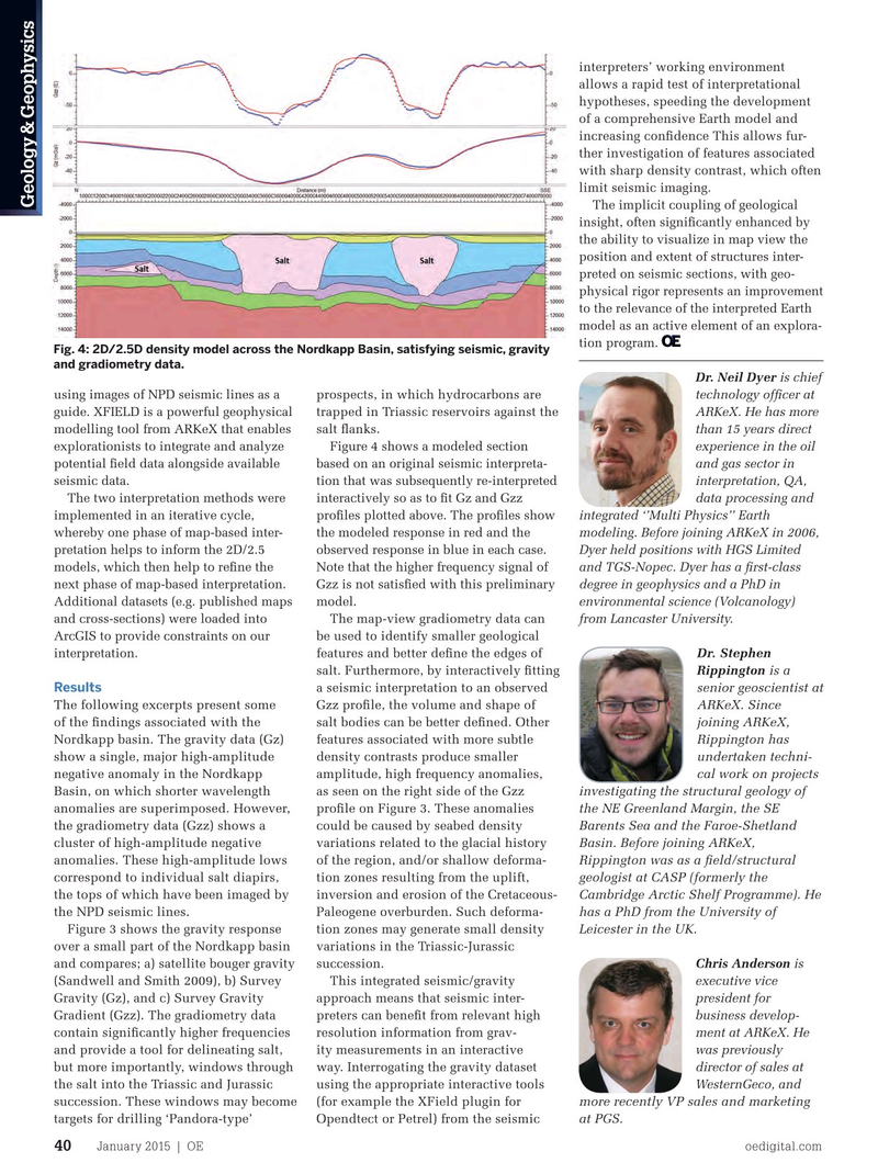
Fig. 4: 2D/2.5D density model across the Nordkapp Basin, satisfying seismic, gravity and gradiometry data.
Dr. Neil Dyer is chief using images of NPD seismic lines as a prospects, in which hydrocarbons are technology offcer at guide. XFIELD is a powerful geophysical trapped in Triassic reservoirs against the ARKeX. He has more modelling tool from ARKeX that enables salt fanks. than 15 years direct explorationists to integrate and analyze Figure 4 shows a modeled section experience in the oil potential feld data alongside available based on an original seismic interpreta- and gas sector in seismic data. tion that was subsequently re-interpreted interpretation, QA,
The two interpretation methods were interactively so as to ft Gz and Gzz data processing and implemented in an iterative cycle, profles plotted above. The profles show integrated ‘’Multi Physics’’ Earth whereby one phase of map-based inter- the modeled response in red and the modeling. Before joining ARKeX in 2006, pretation helps to inform the 2D/2.5 observed response in blue in each case. Dyer held positions with HGS Limited models, which then help to refne the Note that the higher frequency signal of and TGS-Nopec. Dyer has a frst-class next phase of map-based interpretation. Gzz is not satisfed with this preliminary degree in geophysics and a PhD in
Additional datasets (e.g. published maps model. environmental science (Volcanology) and cross-sections) were loaded into The map-view gradiometry data can from Lancaster University.
ArcGIS to provide constraints on our be used to identify smaller geological
Dr. Stephen interpretation. features and better defne the edges of
Rippington is a salt. Furthermore, by interactively ftting
Results senior geoscientist at a seismic interpretation to an observed
The following excerpts present some ARKeX. Since
Gzz profle, the volume and shape of of the fndings associated with the joining ARKeX, salt bodies can be better defned. Other
Nordkapp basin. The gravity data (Gz) Rippington has features associated with more subtle show a single, major high-amplitude undertaken techni- density contrasts produce smaller negative anomaly in the Nordkapp cal work on projects amplitude, high frequency anomalies,
Basin, on which shorter wavelength investigating the structural geology of as seen on the right side of the Gzz anomalies are superimposed. However, the NE Greenland Margin, the SE profle on Figure 3. These anomalies the gradiometry data (Gzz) shows a Barents Sea and the Faroe-Shetland could be caused by seabed density cluster of high-amplitude negative Basin. Before joining ARKeX, variations related to the glacial history anomalies. These high-amplitude lows Rippington was as a feld/structural of the region, and/or shallow deforma- correspond to individual salt diapirs, geologist at CASP (formerly the tion zones resulting from the uplift, the tops of which have been imaged by Cambridge Arctic Shelf Programme). He inversion and erosion of the Cretaceous- the NPD seismic lines. has a PhD from the University of
Paleogene overburden. Such deforma-
Figure 3 shows the gravity response tion zones may generate small density
Leicester in the UK. over a small part of the Nordkapp basin variations in the Triassic-Jurassic and compares; a) satellite bouger gravity succession. Chris Anderson is (Sandwell and Smith 2009), b) Survey This integrated seismic/gravity executive vice
Gravity (Gz), and c) Survey Gravity approach means that seismic inter- president for
Gradient (Gzz). The gradiometry data preters can beneft from relevant high business develop- contain signifcantly higher frequencies resolution information from grav- ment at ARKeX. He and provide a tool for delineating salt, ity measurements in an interactive was previously but more importantly, windows through way. Interrogating the gravity dataset director of sales at the salt into the Triassic and Jurassic using the appropriate interactive tools WesternGeco, and more recently VP sales and marketing succession. These windows may become (for example the XField plugin for at targets for drilling ‘Pandora-type’ Opendtect or Petrel) from the seismic PGS.
January 2015 | OE oedigital.com 40 038_OE0115_G&G2_Arkex.indd 40 12/22/14 10:00 PM