
Page 54: of Offshore Engineer Magazine (Jul/Aug 2019)
Subsea Processing
Read this page in Pdf, Flash or Html5 edition of Jul/Aug 2019 Offshore Engineer Magazine
 53
53
 55
55
TECH FILES 3D Inversion
Tackling Complex Reservoirs
By Jennifer Pallanich alliburton leveraged technology from the mining The 3D inversion capability uses Halliburton’s existing industry to reveal subsurface structures in a way EarthStar ultra-deep resistivity service, an LWD technology that improves geosteering, geomapping and geos- that identi? es reservoir and ? uid boundaries up to 68 meters
H topping in complex reservoirs. from the wellbore. EarthStar 3D Inversion reveals features
The service company has recently introduced EarthStar 3D such as faults, water zones or local structural variations such
Inversion, a 3D reservoir mapping process that, when used in as injectities, which could alter the optimal landing trajectory geosteering applications, can maximize contact with oil and of a well, according to Halliburton.
gas zones while mapping the surrounding formation to iden- “The industry now has a solution to understand the hydro- tify bypassed oil, avoid drilling hazards and plan for future carbon distribution in the reservoir that wasn’t there before,” development. Zurcher says.
Derick Zurcher, Halliburton’s strategic business manager The new capability has been run in about a dozen wells for measurement-while-drilling (MWD)/logging-while-drill- offshore, including the North Sea and in the Americas.
ing (LWD), says the service company worked with mining In one run for Aker BP offshore Norway in late 2018, the software specialists Computational Geosciences, based in operator was aware of complex geology involving turbidite
Vancouver, to “break down this large mathematical problem” channels and wanted to be able to optimally land the wellbore of how to process the large number of measurements into a in the reservoir.
fully resolved 3D volume that could be useful in geosteering 1D inversion showed isolated sand bodies, Zurcher says, applications. but 3D inversion “showed the true shape and extent of these “They were looking at where the ore distribution is in the channels and whether they’re connected, which was impor- subsurface. We’re trying to do the same thing, where is the tant for completion design and production.” distribution of oil and gas?” Zurcher says. The service could be useful beyond real-time geosteering
Currently, reservoir data used for geosteering typically applications, he says, including use in mapping the water comes from seismic, which may not “see” features smaller front in a reservoir.
than 150 feet, and while-drilling tools that take measurements “We believe this isn’t just a formation evaluation service. It near the wellbore. This leaves “a big gap” between the two, goes beyond that,” he says, adding that it provides important
Zurcher says. “For the ? rst time, we have a service which can input for the completion and production phases of reservoir resolve that intermediate scale.” development.
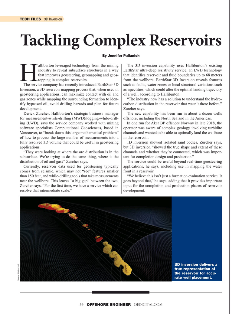
3D inversion delivers a true representation of the reservoir for accu- rate well placement.
(Source: Halliburton) 54 OFFSHORE ENGINEER OEDIGITAL.COM