Chart Technology
-
- Charting The World Electronically Maritime Reporter, Apr 2000 #44
The advent of electronic chart technology has left ship and boat owners with an unprecedented tool to aid in safe and efficient navigation. But while the electronic advances have swept interest and headlines around the world, they have also created a considerable amount of confusion regarding, for example, when electronic charts can legally replace paper versions.
With the notion of clearing the air, MR/EN has spoken with one of the world's leading companies in the field, CMap, to discuss the ins and outs of new electronic chart technology.
Currently, ship owners are focusing on the availability of quality electronic chart data for ECDIS. C-Map, being the largest supplier of charts in digital format, has responded to the requirements by offering worldwide coverage on CD ROM. The data from C-Map is coded in proprietary System Electronic Navigational Chart (SENC), optimized for direct use by the onboard ECDIS computer. This format, dubbed CM93 by C-Map, has been adopted by many manufacturers of ECDIS systems (Please see Table l).
ENC & ECDIS It is imperative to note that only National Hydrographic Offices (HOs) can issue Electronic Navigation Charts (ENC) data as a paper chart replacement. HOs can, and do. subcontract work to commercial companies, but the HO is ultimately responsible for data quality control. Only when ENCs are displayed on a typeapproved ECDIS system can they replace paper charts.
The International Hydrographic Organization (IHO) has defined the ENC chart format specified in the S-57 Edition 3 (S- 57/3) product specification, which is a detailed format developed as a data exchange format to be used by HOs. It is not a format designed to be manipulated and displayed on a navigation screen, and for this reason the ECDIS Performance Standards accept that ENC data is compiled into an internal format in the ECDIS system, or in a SENC format. Thus, one of the more critical steps is ensuring the integrity of the data when compiling from ENC to SENC format. The presentation of nautical charts and symbols on a navigation system is defined by the IHO as well, in the S52 specification, which is also referred to in the ECDIS Performance Standards.
Partnerships C-Map, in effect, acts as a link between the HOs and the users of digital nautical charts, and the company is constantly developing new technology and services to achieve this goal. C-Map is not only working with HOs to digitize paper charts, but working with them also to develop their national ENC portfolios in S-57/3. C-Map developed the CM-93 Edition 3 (CM-93/3) format that fully complies with the S-57/3 format as defined by the IHO.
Data produced by C-Map is produced in CM-93/3 format, which is used by a number of system manufacturers as their SENC format. C-Map has developed software that compiles S-57/3 data in CM- 93/3 format. The compiler was typeapproved by DNV, to ensure that there is no loss or corruption of data in this process. This compiler is suppled to system manufacturers that use CM-93/3 as a SENC to enable their systems to read S- 57/3 data directly.
The CM-93/2 chart portfolio of 13,900 chart files produced by C-Map has been converted into the same CM-93/3 SENC format, but it can only be used as an aid to navigation. ECDIS systems that use CM- 93/3 have access to extensive chart coverage.
As ENC data becomes available, this will take priority over other data and be clearly recognized as official data when displayed, but unfortunately only limited ENC data is presently available.
Distributing charts in the SENC format means that the updating of charts can be carried out via the Internet, or remote access using a shipboard communications line. The SENC format, in effect, is a compressed format (approx. 1:5) in comparison to S-57/3, and additionally, no compression is required onboard.
Circle 137 on Reader Service Card
-
 )
March 2024 - Marine Technology Reporter page: 48
)
March 2024 - Marine Technology Reporter page: 48Index page MTR MarApr2024:MTR Layouts 4/4/2024 3:19 PM Page 1 Advertiser Index PageCompany Website Phone# 17 . . . . .Airmar Technology Corporation . . . . . . . . . .www.airmar.com . . . . . . . . . . . . . . . . . . . . . . . . . . . . . . . . .(603) 673-9570 9 . . . . . .Birns, Inc. . . . . . . . . . .
-
 )
March 2024 - Marine Technology Reporter page: 47
)
March 2024 - Marine Technology Reporter page: 47PRODUCT, PROFESSIONAL, VESSELS, MTR BARGES & REAL ESTATE FOR SALE Marketplace INNOVATIVE. UNIQUE. PROVEN. ALLAMERICANMARINE.com ???????????????????????????????????????? 9??????????SiC A????????ArC????????????????S???????C?????????9???Ç????????? ????????????????Ý???????S???y???????????????????K???:???? MAR
-
 )
March 2024 - Marine Technology Reporter page: 45
)
March 2024 - Marine Technology Reporter page: 45ronments. The new agreement will address speci? c techni- cal gaps in the UUV defense and offshore energy markets especially for long duration, multi-payload mission opera- tions where communications are often denied or restricted. As part of the new alliance, Metron’s Resilient Mission Autonomy portfolio
-
 )
March 2024 - Marine Technology Reporter page: 44
)
March 2024 - Marine Technology Reporter page: 44Robotics Partner can be integrated with high resolution multibeam systems and Metron signed a partnership agreement with Cellula Ro- the CARIS Ping-To-Chart work? ow, allowing for full above- botics, USA Inc., to expand uncrewed underwater vehicle and-below- water image capture with survey grade accuracy
-
 )
March 2024 - Marine Technology Reporter page: 43
)
March 2024 - Marine Technology Reporter page: 43Image courtesy Kongsberg Discovery Image courtesy Teledyne Marine New Products Teledyne Marine had its traditional mega-booth at Oi, busy start to ? nish. Image courtesy Greg Trauthwein offers quality sub-bottom pro? ling capability without the need tion of offshore windfarms. GeoPulse 2 introduces new
-
 )
March 2024 - Marine Technology Reporter page: 41
)
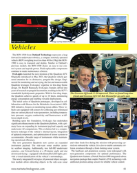
March 2024 - Marine Technology Reporter page: 41Image courtesy Outland Technology Image courtesy Exail Image courtesy Submaris and EvoLogics Vehicles The ROV-1500 from Outland Technology represents a leap forward in underwater robotics, a compact remotely operated vehicle (ROV) weighing in at less than 40 lbs (19kg) the ROV- 1500 is easy to transport
-
 )
March 2024 - Marine Technology Reporter page: 40
)
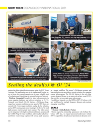
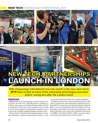
March 2024 - Marine Technology Reporter page: 40NEW TECH OCEANOLOGY INTERNATIONAL 2024 All photos courtesy MTR unless otherwise noted NEW TECH, PARTNERSHIPS LAUNCH IN LONDON With Oceanology International now one month in the rear-view mirror, MTR takes a look at some of the interesting technologies launched before, during and after the London event.
-
 )
March 2024 - Marine Technology Reporter page: 33
)
March 2024 - Marine Technology Reporter page: 33regulated industry in the world.” How- ever, commercial success depends on many factors, not least a predictable OPEX. Over the past four years, SMD has worked with Oil States Industries to calculate cost per tonne ? gures for prospective customers. Patania II uses jet water pumps to Oil States’
-
 )
March 2024 - Marine Technology Reporter page: 32
)
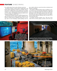
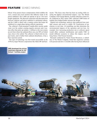
March 2024 - Marine Technology Reporter page: 32FEATURE SEABED MINING by a sea? oor plume from its pilot collection system test. pact, nodule collection system that utilizes mechanical and The Metals Company recently signed a binding MoU with hydraulic technology. Paci? c Metals Corporation of Japan for a feasibility study on The company’s SMD
-
 )
March 2024 - Marine Technology Reporter page: 30
)
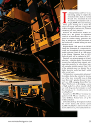
March 2024 - Marine Technology Reporter page: 30FEATURE SEABED MINING bilical. It has passive heave compensation which nulli? es the necott. “The focus since then has been on scaling while en- wave, current and vessel motions that in? uence loads in the suring the lightest environmental impact,” says The Metals power umbilical. The LARS can
-
 )
March 2024 - Marine Technology Reporter page: 29
)
March 2024 - Marine Technology Reporter page: 29n January, Norway said “yes” to sea- bed mining, adding its weight to the momentum that is likely to override the calls for a moratorium by over 20 countries and companies such as I Google, BMW, Volvo and Samsung. Those against mining aim to protect the unique and largely unknown ecology of the sea?
-
 )
March 2024 - Marine Technology Reporter page: 27
)
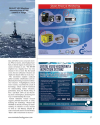
March 2024 - Marine Technology Reporter page: 27SEA-KIT USV Maxlimer returning from HT-HH caldera in Tonga. © SEA-KIT International data and further assess ecosystem recov- ery. What is known, noted Caplan-Auer- bach, is that the impact of submarine vol- canoes on humans is rare. “The HT-HH eruption was a tragedy, but it was very unusual. It let us
-
 )
March 2024 - Marine Technology Reporter page: 26
)
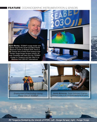
March 2024 - Marine Technology Reporter page: 26FEATURE OCEANOGRAPHIC INSTRUMENTATION & SENSORS Kevin Mackay, TESMaP voyage leader and Center head of the South and West Paci? c Regional Centre of Seabed 2030. Kevin in the seismic lab at Greta Point looking at the Hunga Tonga-Hunga Ha’apai volcano 3D map completed with data from the TESMaP voyage
-
 )
March 2024 - Marine Technology Reporter page: 25
)
March 2024 - Marine Technology Reporter page: 25Auerbach explained that ideally, “one ? ed layers of geothermal activity,” noted changes over an area of 8,000 km2. They would have both instruments: seismom- Skett, “and the change in salinity and dis- found up to seven km3 of displaced ma- eters to detect and locate subsurface ac- solved particles for
-
 )
March 2024 - Marine Technology Reporter page: 23
)
March 2024 - Marine Technology Reporter page: 23elatively inactive since 2014, the Hunga Tonga–Hunga Ha‘apai (HT-HH) submarine volcano began erupting on December 20, 2021, reaching peak intensity on January 15, 2022. This triggered tsunamis throughout the Pa- R ci? c, destroyed lives and infrastructure, and generated the largest explosion recorded
-
 )
March 2024 - Marine Technology Reporter page: 20
)
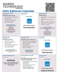
March 2024 - Marine Technology Reporter page: 202024 Editorial Calendar January/Februay 2024 February 2024 March/April 2024 Ad close Jan.31 Ad close March 21 Ad close Feb. 4 Underwater Vehicle Annual Offshore Energy Digital Edition ?2?VKRUH:LQG$)ORDWLQJ)XWXUH ?2FHDQRJUDSKLF?QVWUXPHQWDWLRQ 6HQVRUV ?6XEVHD'HIHQVH ?6XEVHD'HIHQVH7KH+XQWIRU ?0DQLS
-
 )
March 2024 - Marine Technology Reporter page: 19
)
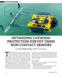
March 2024 - Marine Technology Reporter page: 19is not required, resulting in signi? - Svenn Magen Wigen is a Cathodic Protection and corrosion control cant cost savings, mainly related to vessel charter. expert having worked across The major advantage of using FiGS on any type of subsea engineering, design, modelling, structure is the large amount
-
 )
March 2024 - Marine Technology Reporter page: 18
)
March 2024 - Marine Technology Reporter page: 18TECH FEATURE IMR There are also weaknesses in terms of accuracy because of FiGS Operations and Bene? ts signal noise and the ability to detect small ? eld gradients. In Conventional approaches to evaluating cathodic protection this process there is a risk that possible issues like coating (CP)
-
 )
March 2024 - Marine Technology Reporter page: 17
)
March 2024 - Marine Technology Reporter page: 17• Integrity assessment, and otherwise covered, e.g., by rock dump. As for depletion of • Mitigation, intervention and repair. sacri? cial anodes, this can be dif? cult or even impossible to Selecting the best method for collecting the data these work- estimate due to poor visibility, the presence of
-
 )
March 2024 - Marine Technology Reporter page: 16
)
March 2024 - Marine Technology Reporter page: 16TECH FEATURE IMR Image courtesy FORCE Technology OPTIMIZING CATHODIC PROTECTION SURVEY USING NON-CONTACT SENSORS By Svenn Magen Wigen, FORCE Technology he principle behind sacri? cial anodes, which are water structures, reducing the need for frequent repairs and used to safeguard underwater pipelines
-
 )
March 2024 - Marine Technology Reporter page: 15
)
March 2024 - Marine Technology Reporter page: 15sensor options for longer mission periods. About the Author For glider users working in ? sheries and conservation, Shea Quinn is the Product Line Manager the Sentinel can run several high-energy passive and active of the Slocum Glider at Teledyne Webb acoustic sensors, on-board processing, and imaging
-
 )
March 2024 - Marine Technology Reporter page: 13
)
March 2024 - Marine Technology Reporter page: 13nyone familiar with glider hardware options integrated for a broad Glider answers that need,” said Shea autonomous underwater ve- range of missions. Quinn, Slocum Glider Product Line hicles (AUVs) is certainly “As the use of Slocum Gliders grew, Manager at TWR. A familiar with the popular- so did
-
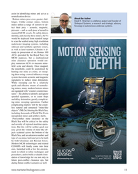 )
March 2024 - Marine Technology Reporter page: 11
)
March 2024 - Marine Technology Reporter page: 11assist in identifying mines and act as a neutralization device. About the Author Bottom mines pose even greater chal- David R. Strachan is a defense analyst and founder of lenges. Unlike contact mines, bottom Strikepod Systems, a research and strategic advisory mines utilize a range of sensors to
-
 )
March 2024 - Marine Technology Reporter page: 9
)
March 2024 - Marine Technology Reporter page: 9from marinas along the western coast. The exact number of lizing laser detection systems can detect mines just below the mines, as well as their locations, remains largely a mystery, surface, even those hiding in murky water. The Airborne Laser although reports suggest that over three hundred have been