Page 31: of Marine Technology Magazine (Nov/Dec 2006)
Deep Ocean Exploration
Read this page in Pdf, Flash or Html5 edition of Nov/Dec 2006 Marine Technology Magazine
 30
30
 32
32
www.seadiscovery.com Marine Technology Reporter 31 responsible for developing and applying new technologies to provide more accurate and timely charting and oceano- graphic information.
We know a lot more about MARS at this point than we do about the ocean floor. In fact we have mapped approx- imately 20 percent of the ocean floor. There is so much more to do and there are many opportunities of adventure and exploration.”
All the satellites, fly-overs, sonar "lawn mowing" and data in the world will not solve the problem, what is need- ed and what has become available are products that enable the seafloor data to be displayed for a variety of users. One company that specializes in data assimilation for oceano- graphic users, is Interactive Visualization Systems (IVS- 3D). Its Fledermaus software enables users to interact with massive geographical data sets of all types. Additionally, L- 3 Communications Klein Associates,
Inc. manufactures side scan sonar sys- tems that have been used to locate the
Titanic, the wreckage of the space shut- tle, Challenger and many other items that appear on the seafloor. The systems provide high speed, full bottom cover- age at very high resolution to world navies, government agencies, offshore energy companies and researchers all over the globe.
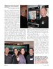
Over 250 teachers and students attended the one day event at UNH. They were treated to hundreds of maps created by various groups showing an infinite array of ways to display marine related data. Several colleges were on hand to provide information to the students about the programs they offer to help launch students into geospa- tial careers. Anne Witzig, a high school science teacher at the Essex Agricultural and Technical High School in
Hawthorne, MA brings her Marine Biology Students here every year to learn about how to use GIS, Geographic
Information Service to map the migration of whales up and down the east coast. (L-R) Essex Agricultural and Technical
High School students Nick Galloway, teacher, Anne Witzig, Mike Dannehy,
Kelly Noonan, Robert Perocchi,
Colleen Cannon, Heather Birchmore visited the GIS Day at UNH as part of their course on using GIS to map wet- lands. (Photo Credit: Maggie L. Merrill, MTR)
UNH Center for Coastal and Ocean Mapping & Joint Hydrographic Center
UNH Center for Coastal and Ocean Mapping & Joint Hydrographic Center is a national center for expertise in ocean mapping and hydrographic sciences. It is housed within the Ocean Engineering Department and it has grown from 12 people when it started in 2000 to more than 50 people now. With the $2 million addition scheduled to be built in 2007, that number will grow.
The JHC & CCOM hosts a "Telepresence Center" that links with shipboard scientists such as Dr. Robert Ballard at
URI. The JHC assists with real time data processing of the bottom surveys that Ballard and crew conducted this past summer. Those data were transmitted to UNH, processed and sent back, live for the scientists and ship's crew to make decisions about where to deploy additional bottom sampling equipment. This is one of many cutting edge research projects underway at the center. Lead by Andy Armstrong and Larry Mayer, both centers are forging ahead to attract the best and the brightest to the field of hydrograhy. Guided by a Memorandum of Understanding with the National Oceanic and Atmospheric Administration (NOAA), the JHC operates in partnership with NOAA's
National Ocean Service. The CCOM is a University center that expands the scope of interaction and cooperation with the private sector, other government agencies and universities. In addition to NOAA support, CCOM currently has projects underway funded by the US Geological Survey, the Office of Naval Research, the Naval Research Lab,
DARPA, NSF and several private sector partners. The centers focus their activities on two major tasks, an educa- tional task, aimed at creating a learning center that will promote and foster the education of a new generation of hydrographers and ocean mapping scientists, and a research task aimed at developing and evaluating a wide range of state-of-the-art hydrographic and ocean mapping technologies and applications.
MTR#9 (17-32).qxd 11/13/2006 4:49 PM Page 31