Page 29: of Marine Technology Magazine (May/Jun 2008)
Undersea Defense Edition
Read this page in Pdf, Flash or Html5 edition of May/Jun 2008 Marine Technology Magazine
 28
28
 30
30
www.seadiscovery.com Marine Technology Reporter 29 between 10 Hz and 20 Hz.
So long as we could know the real-world location (in coordinates) of our starting point, we would be able to use the aided INS to generate a displacement from the start- point that takes into consideration the entire course trav- eled, because each position solution is a function of the previously recorded position. The added benefit of the aided INS is that, with an RLG at its core, it could pro- vide very accurate heading and attitude referencing to cor- rect for the attitude of the ROV.
INS Combined with 3D Model
Due to the low visibility anticipated in the Cigar Lake
Mine, it was necessary that a means of navigating the
ROV be developed that would not only position the ROV in real-time but also provide an expedient means of map- ping any debris or obstructions as they were identified in order to minimize the risk of entrapment.
To this end, SeaVision set to developing a virtual 3D model of the mine system based on drawings provided by
Cameco. SeaVision selected Hypack, a hydrographic sur- vey software popular throughout North America, as the platform for developing this model. As a survey software, it would provide userfriendly inputs for importing the real-time positioning and attitude information from the
INS on the SeaEye Falcon ROV. A recently added feature to the software, the 3-D Terrain Viewer (3DTV) would provide the ability to view the real-time position of the
ROV in plan-view as well as in a 3-Dimensional Viewer.
Fortunately, Cameco had developed very accurate three- dimensional survey drawings of the subterranean mine well before the flooding accident. These drawings had been geographically referenced to a coordinate system directly related to the Universal Transverse Mercator (UTM) grid, so that simple translations could bring these electronic drawings (in AutoCad format) into the UTM geographic coordinate grid.
Using the drawings as background information,
SeaVision utilized the Hypack 3DTV Utility to develop a conceptual, fully georeferenced model of the principle fea- tures of the mine that would be encountered during the
ROV missions to the open bulkhead door. Using simple geometric shapes like pipes and shells, SeaVision matched the general three-dimensional layout of the mine and gen- erate a conceptual model of the mine.
Hypack can be configured to accept the position and attitude inputs, in real-time, from the INS so that the
ROV can be displayed within both the 2-D plan view lay-
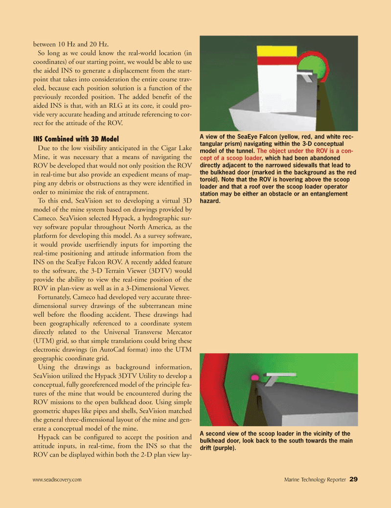
A view of the SeaEye Falcon (yellow, red, and white rec- tangular prism) navigating within the 3-D conceptual model of the tunnel. The object under the ROV is a con- cept of a scoop loader, which had been abandoned directly adjacent to the narrowed sidewalls that lead to the bulkhead door (marked in the background as the red toroid). Note that the ROV is hovering above the scoop loader and that a roof over the scoop loader operator station may be either an obstacle or an entanglement hazard.
A second view of the scoop loader in the vicinity of the bulkhead door, look back to the south towards the main drift (purple).
MTR#4 (17-32).qxd 5/13/2008 10:00 AM Page 29