
Page 56: of Marine Technology Magazine (Mar/Apr 2014)
Instrumentation: Measurement, Process & Analysis
Read this page in Pdf, Flash or Html5 edition of Mar/Apr 2014 Marine Technology Magazine
 55
55
 57
57
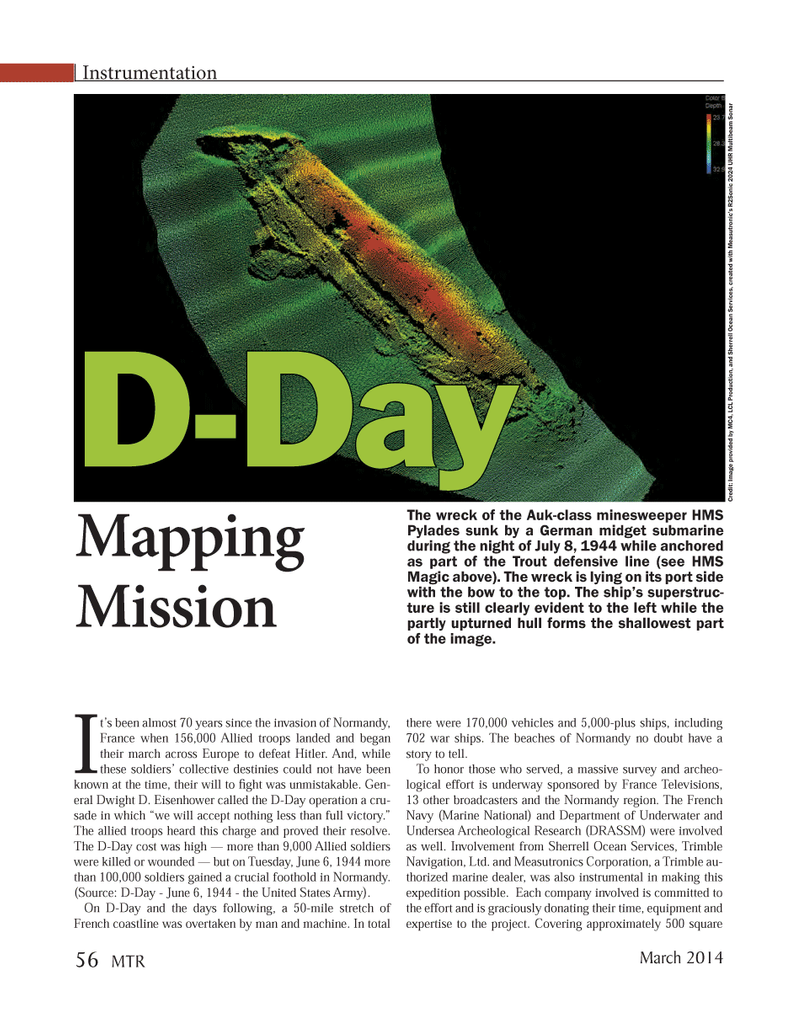
It?s been almost 70 years since the invasion of Normandy, France when 156,000 Allied troops landed and began their march across Europe to defeat Hitler. And, while these soldiers? collective destinies could not have been known at the time, their will to ght was unmistakable. Gen- eral Dwight D. Eisenhower called the D-Day operation a cru- sade in which ?we will accept nothing less than full victory.? The allied troops heard this charge and proved their resolve. The D-Day cost was high ? more than 9,000 Allied soldiers were killed or wounded ? but on Tuesday, June 6, 1944 more than 100,000 soldiers gained a crucial foothold in Normandy. (Source: D-Day - June 6, 1944 - the United States Army). On D-Day and the days following, a 50-mile stretch of French coastline was overtaken by man and machine. In total there were 170,000 vehicles and 5,000-plus ships, including 702 war ships. The beaches of Normandy no doubt have a story to tell. To honor those who served, a massive survey and archeo- logical effort is underway sponsored by France Televisions, 13 other broadcasters and the Normandy region. The French Navy (Marine National) and Department of Underwater and Undersea Archeological Research (DRASSM) were involved as well. Involvement from Sherrell Ocean Services, Trimble Navigation, Ltd. and Measutronics Corporation, a Trimble au- thorized marine dealer, was also instrumental in making this expedition possible. Each company involved is committed to the effort and is graciously donating their time, equipment and expertise to the project. Covering approximately 500 square Instrumentation D-Day D-DayMapping Mission The wreck of the Auk-class minesweeper HMS Pylades sunk by a German midget submarine during the night of July 8, 1944 while anchored as part of the Trout defensive line (see HMS Magic above). The wreck is lying on its port side with the bow to the top. The ship?s superstruc- ture is still clearly evident to the left while the partly upturned hull forms the shallowest part of the image. Credit: Image provided by MC4, LCL Production, and Sherrell Ocean Services, created with Measutronic?s R2Sonic 2024 UHR Multibeam Sonar March 2014 56 MTRMTR #2 (50-65).indd 56MTR #2 (50-65).indd 562/21/2014 11:29:53 AM2/21/2014 11:29:53 AM