Page 51: of Marine Technology Magazine (Jun/Jul 2014)
Hydrographic Survey
Read this page in Pdf, Flash or Html5 edition of Jun/Jul 2014 Marine Technology Magazine
 50
50
 52
52
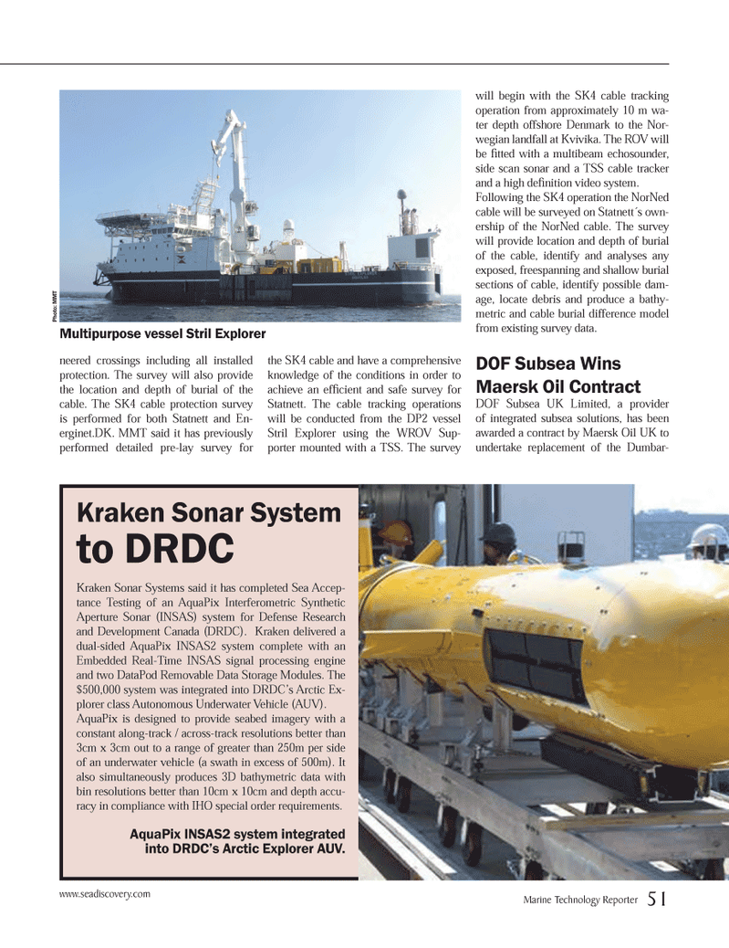
neered crossings including all installed protection. The survey will also provide the location and depth of burial of the cable. The SK4 cable protection survey is performed for both Statnett and En- erginet.DK. MMT said it has previously performed detailed pre-lay survey for the SK4 cable and have a comprehensive knowledge of the conditions in order to achieve an effi cient and safe survey for
Statnett. The cable tracking operations will be conducted from the DP2 vessel
Stril Explorer using the WROV Sup- porter mounted with a TSS. The survey will begin with the SK4 cable tracking operation from approximately 10 m wa- ter depth offshore Denmark to the Nor- wegian landfall at Kvivika. The ROV will be fi tted with a multibeam echosounder, side scan sonar and a TSS cable tracker and a high defi nition video system.
Following the SK4 operation the NorNed cable will be surveyed on Statnett´s own- ership of the NorNed cable. The survey will provide location and depth of burial of the cable, identify and analyses any exposed, freespanning and shallow burial sections of cable, identify possible dam- age, locate debris and produce a bathy- metric and cable burial difference model from existing survey data.
DOF Subsea Wins
Maersk Oil Contract
DOF Subsea UK Limited, a provider of integrated subsea solutions, has been awarded a contract by Maersk Oil UK to undertake replacement of the Dumbar-
Kraken Sonar System to DRDC
Kraken Sonar Systems said it has completed Sea Accep- tance Testing of an AquaPix Interferometric Synthetic
Aperture Sonar (INSAS) system for Defense Research and Development Canada (DRDC). Kraken delivered a dual-sided AquaPix INSAS2 system complete with an
Embedded Real-Time INSAS signal processing engine and two DataPod Removable Data Storage Modules. The $500,000 system was integrated into DRDC’s Arctic Ex- plorer class Autonomous Underwater Vehicle (AUV).
AquaPix is designed to provide seabed imagery with a constant along-track / across-track resolutions better than 3cm x 3cm out to a range of greater than 250m per side of an underwater vehicle (a swath in excess of 500m). It also simultaneously produces 3D bathymetric data with bin resolutions better than 10cm x 10cm and depth accu- racy in compliance with IHO special order requirements.
AquaPix INSAS2 system integrated into DRDC’s Arctic Explorer AUV.
Photo: MMT
Multipurpose vessel Stril Explorer www.seadiscovery.com
Marine Technology Reporter 51
MTR #5 (50-64).indd 51 6/9/2014 10:58:40 AM