
Page 21: of Maritime Reporter Magazine (October 15, 1984)
Read this page in Pdf, Flash or Html5 edition of October 15, 1984 Maritime Reporter Magazine
 20
20
 22
22
BETTER IMAV SAFE THAN SORRY.
ELECTRONIC CHART NAVIGATION SYSTEM
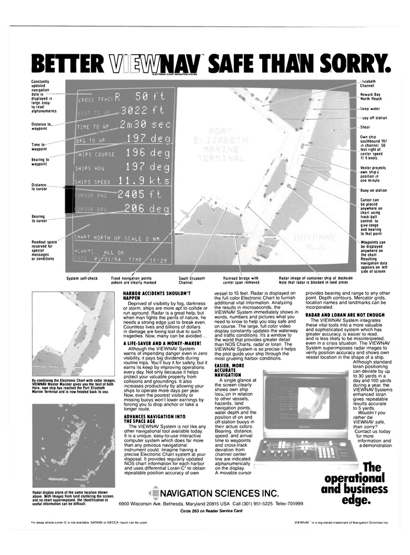
Constantly updated navigation data is — displayed in large,easy- to-read alphanumerics
Distance to. waypoint
Time to - waypoint
Bearing to waypoint
Oistance. to cursor
Bearing to cursor '
Readout space' reserved for special messages or conditions
V
CROSS TRACKR 50 t t ft
TIME TOJJF^2rn30 s e c
J 9 7 d e q
HIPS COURSE 196 deg (SHIPS HDG 19 7 d e g
HIPS SPEED 11.9 k t 5 TO WP
BRG TO WP
SHIP D
LCHHPT NORTH UP SCALE 2 NH /
JALARHS ALL OK 8UT31/R4 TTMPXC;;?Q
System selt-check /
Fixed navigation points ashore are clearly marked lizabeth
Channel
Newark Bay
North Reach fieep water uoy oft station
Shoal
Own ship southbound 197 in channel 50 feet right of center speed 119 knots
Vector proiects own ship s position in one minute
Buoy on station
Cursor can be placed anywhere on chart using track-ball control, to give range and bearing to that point
Waypoints can be displayed anywhere on the chart
Resulting navigation data appears on left side of screen
South Elizabeth
Channel
Railroad bridge with center span removed
Radar image of container ship at dockside
Note that radar is blocked in land areas
By combining the Electronic Chart with radar images.
VIEWNAV Master Mariner gives you the best of both.
Here, own ship has reached the Port Elizabeth
Marine Terminal and is now headed back to sea.
HARBOR ACCIDENTS SHOULDN'T
HAPPEN
Deprived of visibility by fog, darkness or storm, ships are more apt to collide or run aground. Radar is a great help, but when man fights the perils of nature, he needs a strong edge just to break even.
Countless lives and billions of dollars in damage are being lost due to such tragedies. Now, many can be avoided...
A LIFE-SAVER AND A MONEY-MAKER!
Although the VIEWNAV System warns of impending danger even in zero visibility, it pays big dividends during routine trips. You'll buy it for safety, but it earns its keep by improving operations every day. Not only because it helps protect your valuable property from collisions and groundings. It also increases productivity by allowing your ships to operate more days per year.
Now, even the poorest visibility or missing buoys won't lower earnings by forcing you to drop anchor or take a longer route.
ADVANCES NAVIGATION INTO
THE SPACE AGE
The VIEWNAV System is not like any other navigational tool available today.
It is a unique, easy-to-use interactive computer system which does far more than any previous navigational instrument could. Imagine having a precise Electronic Chart system at your disposal. It provides regularly updated
NOS chart information for each harbor and uses differential Loran-C* to obtain repeatable position accuracy of own vessel to 15 feet. Radar is displayed on the full color Electronic Chart to furnish additional vital information. Analyzing the results in microseconds, the
VIEWNAV System immediately shows in words, numbers and pictures what you need to know to help you stay safe and on course. The large, full color video display constantly updates the waterway and traffic conditions. It's a window to the world that provides greater detail than NOS Charts, radar or loran. The
VIEWNAV System is so precise it helps the pilot guide your ship through the most grueling harbor conditions.
EASIER, MORE
ACCURATE
NAVIGATION
A single glance at the screen clearly shows own ship loca^on in relation to other vessels, hazards, land navigation points, water depth and the position of on and off-station buoys in their actual colors.
Bearing, distance, speed, and arrival time to waypoints and cross-track deviation from channel center line are indicated alphanumerically on the display.
A movable cursor
Radar display alone of the same location shown above. With images from land cluttering the screen, and no chart superimposed, the identification ot useful information can be difficult.
NAVIGATION SCIENCES INC. 6900 Wisconsin Ave, Bethesda, Maryland 20815 USA Call (301) 951-5225. Telex-705999.
Circle 263 on Reader Service Card provides bearing and range to any other point. Depth contours, Mercator grids, location names and landmarks can be incorporated.
RADAR AND LORAN ARE NOT ENOUGH
The VIEWNAV System integrates these vital tools into a more valuable and sophisticated system which has greater accuracy, is easier to read, and is less likely to be misinterpreted, even in a crisis situation. The VIEWNAV
System superimposes radar images to verify position accuracy and shows own vessel location in the shape of a ship.
Although standard loran positioning can deviate by up to 30 yards in a day and 100 yards during a year, the
VIEWNAV System's enhanced loran gives repeatable results accurate to 5 yards.
Wouldn't you rather be
VIEWNAV safe, than sorry?
Contact us today for more information and a demonstration.
The operational and business edge. *ln areas where Loran-C is not available. SATNAV or DECCA inputs can be used. VIEWNAV " is a registered trademark of Navigation Sciences Inc.
