
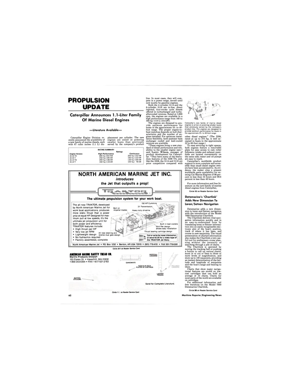
Datamarine's ^Chartlink' Adds New Dimension To Loran/Satnav Navigation
Datamarine adds a new dimension to loran and Satnav navigation with the introduction of the Model 7000 Datamarine Chartlink.
The Chartlink delivers vital navigation information quickly and in an easy-to-understand form by translating loran or Satnav information into an easily recognizable electronic plot of the boat's position, track of where it has been, and course to new waypoints. The visual presentation of charted information also makes the Chartlink a very useful tool for preliminary cruise planning without the necessity of searching through a pile of charts.
The Chartlink is operated by moving the tracking ball or pushing a button to call up various charts, zoom in or out or then to three or more levels of magnification, and store up to 100 waypoints, providing an instant determination of the latitude and longitude of waypoints and the boat's range and bearing to them.
Charts that show major navigational features are stored on lowcost cartridges that can hold an average of 10 charts. Charts for most parts of the world are available on cartridges.
For additional information and free literature on the Model 7000 Datamarine Chartlink, Circle 98 on Reader Service Card
Read Datamarine's ^Chartlink' Adds New Dimension To Loran/Satnav Navigation in Pdf, Flash or Html5 edition of April 1988 Maritime Reporter
Other stories from April 1988 issue
Content
- MHI Delivers Newest Tanker For Chevron Fleet page: 5
- New Nirex Freshwater Distiller And Ice Machine From Alfa-Laval page: 6
- Repower With Cummins NTA-855-Ms Gives Pushboat A New Life page: 7
- System Expansion For WLO Radio page: 7
- Penn Ship Names Veteran Shipbuilder Grandin Vought Operations Vice President page: 7
- Krupp Atlas Elektronik Navaids page: 8
- A.S.N.E. DAY '88 A CENTENNIAL CELEBRATION page: 10
- Aeroquip Offers Free Hose Line Training Bulletin page: 19
- Woodward Governor Forms International Operations Division page: 20
- Moss Point Marine Delivers First Of Two Navy Landing Craft page: 21
- Six-Patrol-Boat 'Package' Completed By Halter Marine For Ecuadoran Navy page: 22
- Two New Low-Cost Products From Furuno: Temperature Sensor, And Net Sounder page: 22
- OTC-'88 20th ANNIVERSARY SPECIAL PREVIEW page: 24
- Astilleros Espanoles Yards Report Full Orderbooks Well Into 1989 page: 50
- New 52-Page Catalog On Lighting Offered By Aqua Signal page: 51
- Radio Holland USA Opens New Service Centers page: 51
- Halter Converts Supply Boat To Crabber/Processor In 90 Days page: 52
- POSITION/LIMIT SENSING SOLUTIONS IN HARSH ENVIRONMENTS page: 54
- Ingalls Shipbuilding Awarded $769-Million Navy Contract To Build Four Aegis Cruisers page: 56
- Riedel International Announces Key Promotions page: 56
- Halter Marine Converts Crewboat For Fisheries Patrol Service page: 57
- Skipperliner Shipyards Delivers Cummins-Powered Passenger Vessel page: 58
- Schaffran Offers Advanced, Compact Controllable Pitch Propeller page: 59
- Port of Genoa Attracts New Container Business Under Innovative Leadership page: 60
- Perkins Marketing Light Marine Engines As Power Prestige Line page: 61
- Literature Offered On Marine Cross Reference Data Base Compact Disc page: 61
- Datamarine's ^Chartlink' Adds New Dimension To Loran/Satnav Navigation page: 62
- Caterpillar Announces 1.1 -Liter Family Of Marine Diesel Engines page: 62
- Robertson-Shipmate's Multi-Station Commercial VHF Radiotelephone Now Approved For Use In U.S. page: 64
- Reiss Purchases Rexnord Defense Systems —Renamed TANO Corp. page: 65
- Free Literature Offered On Full Line Of Steering Gears From Tenf jord page: 65
- Academy Chief Elected To ASNE page: 66
- Deutz MWM Diesel Engine Series Offer Distinct Advantages For Passenger Boat Propulsion page: 66
- Seaward International Supplies Large Fleet Mooring Buoys To Navy For Use In Pacific Islands page: 69
- SASMEX '88 To Be Held April 26-28 In London page: 70
- Hyundai Heavy Industries To Build Ethylene Carriers page: 72
- MAN B&W's New 2 8 / 3 2 A Diesel: Improved Fuel Economy With Same Reliability page: 73
- Fluid Energy Launches 64-Foot Passenger Submarine page: 78
