Page 34: of Maritime Reporter Magazine (December 2002)
Read this page in Pdf, Flash or Html5 edition of December 2002 Maritime Reporter Magazine
 33
33
 35
35
Marine Electronics
C-MAP Plots Its Course On Both Sides
Beginning in the mid-1980's via a brain- storm session for an innovative electron- ic charting system, by partners, Fosco
Bianchetti and Giuseppe Carnevali, C-
MAP has become a force in electronic charting. MR/EN recently traveled to the company's U.S. division, in the heart of historic Cape Cod in Mashpee, Mass. for a firsthand account of how C-MAP compiles its real-time, up-to-the minute charting information.
By Regina P. Ciardiello, managing editor
While the advent of electronic charts is a historic shift in marine navigation — C-MAP has grown since those first years in the mid-80s as a leading provider of vector-based electronic charts and charting systems to recre- ational boaters. In fact, the company prides itself on its ability to hold a library of more than 18,000 electronic charts in its database — covering virtu- ally every port and harbor in the world.
Not limiting itself to one area of exper- tise, C-MAP operates three divisions: C-
MAP Commercial, C-MAP USA and C-
Map Aviation — the latter two operating out of the Mashpee locale.
C-MAP's CM93 edition 3's strategy is based on the business model of being able to implement its electronic charts and electronic charting technology into some of the world's largest original equipment manufacturers (OEM's) navi- gation systems — mainly Sperry
Marine, Japan Radio Company, Kelvin
Hughes and Raytheon — to name a few.
Since expanding into the commercial side more than 10 years ago, C-MAP holds some of the largest vessel owners as clients, and its reference list includes the tanker series currently being con- structed for Polar Tankers, the fleets of the top cruise lines and several West
Coast Tanker owners. The company has also established itself on government vessels. In fact, according to Eric
James, C-MAP's Commercial Opera- tions Manager, seven out of 10 U.S.
Navy aircraft carriers currently afloat, are sailing with C-MAP's electronic charts.
The software also carries over to other branches of the U.S. Armed Forces, specifically the U.S. Army, who imple- mented C-Map's CM-93 Edition 3 earli- er this year on USAV Lt. William B. 34
Bunker - a 273-ft. (83.2-m) logistic sup- ply vessel equipped with Integrated
Navigation and Situational Awareness
Systems (INSA) developed by Conley and Associates of Newport News, Va.
An Italian Foundation
C-Map's database was not developed the same way that its information is processed — overnight. Rather it was a daunting, technologically driven task formulated by Fosco Bianchetti and
Giuseppe Carnevali in 1984. The two men, who co-founded Navionics that same year, built this company to intro- duce a new type of charting that was poised to be a historic change to marine navigation. The systems, which would be an enhanced version of the already established raster systems, would pro- vide better display, speed and have three divisions.
Based upon its recreational product, which by 1991 had already enjoyed sev- eral years of success, C-MAP chose
Norway as the basis for its commercial outlet — an outlet that would provide electronic charts for oceangoing vessels worldwide. Previously commercial ves- sels had only had the option of raster charts, which while they were true-to- life of the paper charts, didn't do much in terms of real-time data; users basical- ly had a photographic image of a con- ventional paper chart. With vector-based charting, although not replicas of paper/raster charts, they do provide higher functionality as opposed to a raster based system. Some examples include: layering of chart data allowing operators to customize the chart display according to their operational needs, greater space for data. Based on official government paper charts, this software would be universal — allowing mariners from the "light" marine world — to plot their courses. Therefore, in 1985, Bianchetti and Carnevali intro- duced the world premiere electronic charting system, Geonav. Following the success of this project, Bianchetti moved ahead, leaving Navionics to establish C-MAP later that year. Build- ing upon the database that was designed in Italy, Bianchetti literally plotted out additional offices throughout Europe, in maritime strongholds such as Norway and Russia, in 1991, when C-MAP extended its product to ocean-going ves- sels. But not before it formed a presence on the other side of the Atlantic in 1988 - under the parent company of C-
MAP/Italy. Beginning with just a hand- ful of employees, the U.S. outfit, which has since moved from Pocasset, Mass. to Mashpee, has evolved into a group of more than 50 employees — within the anti-grounding alarms — preset vessel safe contour and the system "looks ahead" for chart features/depths that can pose navigational hazards, course up or relative motion displays.
CM-93 — Information Via the
Touch of A Button
CM-93 was developed to satisfy the needs of commercial/professional cus- tomers as well as to meet the demands of
IMO's requirements for a S57 compati- ble database for use in ECDIS. Suitable for use in ECS (Electronic Charting Sys- tems),
C-MAP's CM-93 or SENC (System
Electronic Navigational Chart), is DNV (Det Norske Veritas) certified effective- ly allowing the shore based compiling of official ENC's, when available, and is distributed within the CM-93 database.
A major advantage of CM-93 users that want to sail with official ENC's but do not want to deal with the at sea conver- sion of S57 data.
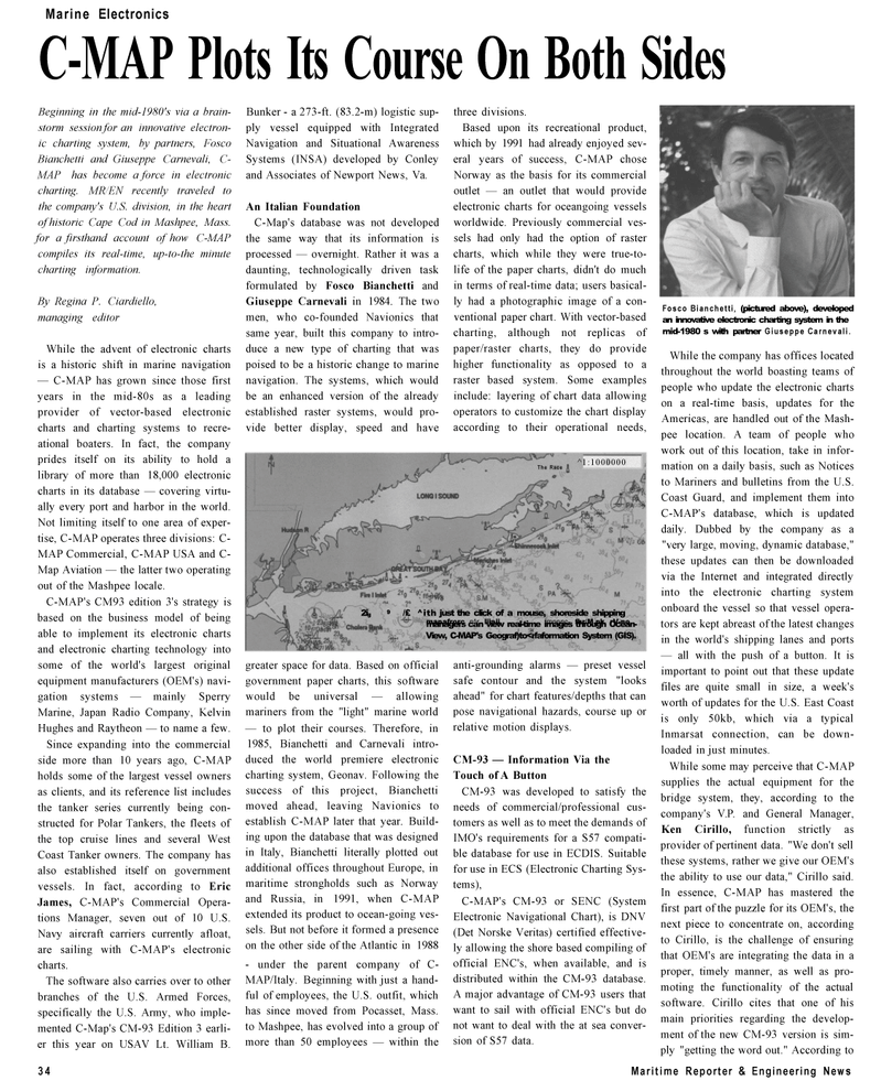
Fosco Bianchetti, (pictured above), developed an innovative electronic charting system in the mid-1980 s with partner Giuseppe Carnevali.
While the company has offices located throughout the world boasting teams of people who update the electronic charts on a real-time basis, updates for the
Americas, are handled out of the Mash- pee location. A team of people who work out of this location, take in infor- mation on a daily basis, such as Notices to Mariners and bulletins from the U.S.
Coast Guard, and implement them into
C-MAP's database, which is updated daily. Dubbed by the company as a "very large, moving, dynamic database," these updates can then be downloaded via the Internet and integrated directly into the electronic charting system onboard the vessel so that vessel opera- tors are kept abreast of the latest changes in the world's shipping lanes and ports — all with the push of a button. It is important to point out that these update files are quite small in size, a week's worth of updates for the U.S. East Coast is only 50kb, which via a typical
Inmarsat connection, can be down- loaded in just minutes.
While some may perceive that C-MAP supplies the actual equipment for the bridge system, they, according to the company's V.P. and General Manager,
Ken Cirillo, function strictly as provider of pertinent data. "We don't sell these systems, rather we give our OEM's the ability to use our data," Cirillo said.
In essence, C-MAP has mastered the first part of the puzzle for its OEM's, the next piece to concentrate on, according to Cirillo, is the challenge of ensuring that OEM's are integrating the data in a proper, timely manner, as well as pro- moting the functionality of the actual software. Cirillo cites that one of his main priorities regarding the develop- ment of the new CM-93 version is sim- ply "getting the word out." According to
Maritime Reporter & Engineering News ^1:1000000 The Race 2ig 9 /£ ^ith just the click of a mouse, shoreside shipping manafrorc n^r, liiaii, \mnnnc- fhr/M.nk rV-no managers can view real-time images through Ocean-
View, C-MAP's Geograf)to
