Page 20: of Maritime Reporter Magazine (October 2003)
Read this page in Pdf, Flash or Html5 edition of October 2003 Maritime Reporter Magazine
 19
19
 21
21
Government Update
Act of 2002 amended the Espionage Act of 1917 to likewise define territorial waters of the United States.
The purpose of this amendment was to allow the Coast Guard to establish and enforce security zones up to 12 miles offshore. There is some question as to whether the amendment achieved the goal as security zones normally are established under the Magnuson Act of 1950.
Several other statutes, though, contin- ue the use of the three mile limit for the
U.S. territorial sea. For instance, the Oil
Pollution Act of 1990 (OPA 90) defines the territorial sea as "the belt of the seas
Circle 261 on Reader Service Card measured from the line of ordinary low water along that portion of the coast, which is in direct contact with the open sea and the line marking the seaward limit of inland waters, and extending seaward a distance of three miles."
The same language is used in the
Federal Water Pollution Control Act (FWPCA).
With similar effect, the Death on the
High Seas Act refers to the high seas as those waters "beyond a marine league from the shore."
Even less clear is the effect, if any, the above legislative changes will have on other measures that rely on the territori- al sea and navigable waters concepts, such as the cabotage laws, but fail to include specific geographic limits.
Coastwise trade concepts are, in large measure, tied to the territorial sea, even though the term is not utilized in the var- ious statutes.
Likewise, the authority of the U.S.
Army Corps of Engineers is tied to the navigable waters of the United States.
The statutes do not define these terms, but Corps regulations provide that its basic jurisdiction extends to three n.m. offshore.
On Waters that are Safe and Navigable
The term navigable waters of the
United States has several meanings, depending on its use. The most com- mon meaning, though, and the one that most impacts mariners, is (1) the territo- rial seas of the United States; (2) internal waters of the United States that are sub- ject to tidal influence; and (3) internal waters of the United States not subject to tidal influence that are or have been used or are susceptible of being used for interstate or foreign commerce. The jurisdictional provisions of numerous federal laws, such as the Ports and
Waterways Safety Act discussed above, utilize this term.
A contiguous zone extending seaward of the territorial sea allows for the enforcement of customs, sanitation, fis- cal. and immigration laws. The United
States adopted and has enforced a 12- mile contiguous zone since the earliest days of the nation.
In 1999, President Clinton issued a
Proclamation extending the U.S. con- tiguous zone to 24 n.m. seaward of the baseline. The avowed purpose was to enhance protection of fisheries resources, but the measure has had little practical effect, since fisheries are large- ly controlled by means of federal statute.
The proclamation did. though, add to the confusion.
In 1945. with offshore oil and gas drilling becoming more productive.
President Truman asserted jurisdiction over the economic resources of the con- tinental shelf off the U.S. coast. The concept has been assimilated into inter- national law.
Ship Design
Naval Architecture
Marine Engineering
Program Management Services
Systems Engineering
Environment Services
Combat Systems Engineering
An Employee Owned Company
Since 1957- Commercial and Naval Ship Design, Detail Design and
Construction Program Support, Marine Consulting,
Pollution Prevention Programs
Alexandria, VA » Washington, DC « New York, NY » Newport News, VA » Pascagoula, MS » Pittsburgh, PA
Philadelphia, PA » Bath, ME « Port Hueneme, CA * Atlantic Beach, FL a Harahan, LA
John J. McMullen Associates, Inc.
Corporate Headquarters 4300 King Street, Suite 400
Alexandria, VA 22302 (703)418-0100
Business Development Office
Phone: (703)933-6690
Fax: (703)933-6777
Web Site: www.JJMA.com
Email: [email protected]
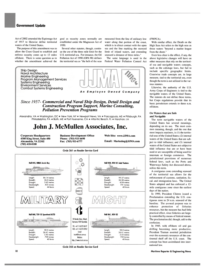
Hull 045, HMAS Jervis Bay
Length:
Breadth:
Draught:
Deadweight:
Speed: 86.1 4 metres 26.0 metres 3.63 metres 41 5 tonnes 44 knots fiMM&Esr
Hull 060, TSV-IX Spearhead ACTD
Length:
Breadth:
Draught:
Deadweight:
Speed: 98.0 metres 26.61 metres 3.43 metres 728 tonnes 40 knots 1 * ft
Tasmania 7009 Australia.
TEL: +61 3 6273 0677
FAX:+61 3 6273 0932 [mail: [email protected]
Website: http: //www.incat.com.au
Hull 050, HSV-XI Joint Venture
Length:
Breadth:
Draught:
Deadweight:
Speed: 99.37 metres 26.58 metres 4.04 metres 741 tonnes 40 knots
Hull 061, HSV-X2
Length:
Breadth:
Draught:
Deadweight:
Speed: 98.0 metres 26.61 metres 3.43 metres 750 tonnes 40 knots
Circle 255 on Reader Service Card 18 Maritime Reporter & Engineering News
