
Page 45: of Offshore Engineer Magazine (Sep/Oct 2014)
Read this page in Pdf, Flash or Html5 edition of Sep/Oct 2014 Offshore Engineer Magazine
 44
44
 46
46
Geology & Geophysics to fve dimensions. GeoSigns is not a fnished system,
The principle behind GeoSigns was however. It is constantly being upgraded. initially called an exploration integrated For example, Shell is working with workspace, or EIW. The idea was to bring NVIDIA and Intel to develop and all the applications together in one space, improve the processing and visualization e.g. they can be accessed from a com- of data for its subsurface applications. mon point from multiple locations. This It is working with such companies to would also bring data, which may have extend the amount of data that can be been stored separately and used in dif- displayed in real time.
ferent ways, through different workfows The amount of data itself is also a together under one workfow. moving target—how much is being stored
GeoSigns includes 29 of Shell’s major and used, Bachmann says. “We see data proprietary technologies, as well as increasing and becoming a bigger chal- applications bought from the market- lenge,” she says. “It is still an acceptable place. “Two-hundred different appli- challenge in areas like the offshore Gulf cations were pulled together in to the of Mexico, where you have very high- different product lines and we simplifed pressured felds, deep underneath the the way they are operating and the way ground, so you fnd substantial volumes they are accessed. This meant there was of hydrocarbons in a small space. When much more data but it also integrated, you start to go on land, [they are] very so 2D and 3D data can be integrated,” different felds you are looking at in order
Bachmann says. to make the economics work. They are
GeoSigns incorporates subsurface bigger, cover a larger area, and you have interpretation software based on seismic to acquire more seismic. It is a com- data, but it also pletely different challenge to offshore.” integrates non- But, while a large amount of the seismic methods, seismic data is currently thrown away, such as gravity and thanks to increased computing power, magnetic survey Bachmann suggests more will be used. data, as well as “In the future we expect we will want “search engines.” to keep more and more of this data.
The Trap Search Acquisition methods will probably, at
Engine automati- least in the immediate future, not neces- cally and rapidly sarily increase the data we have. But we displaying this information and giving scans large seismic will want to utilize a lot more of that data the user access to better imaging under datasets and fnds in the processing. Software is constantly the salt dome. In 2009, we re-drilled the suitable traps operating at the limit of what it can do. well in a different location, much deeper, that interpreters But there is always more ground to cover. under the neck of the salt dome, and it might miss. The The trick for us is in the extraction and was a discovery, confrming the existence Seismic Well Tie making sense of it. of the West Boreas feld.” Soon after fts seismic to well “There is still a long way to go. The another feld, South Deimos, was discov- logs, aiding more industry is still drilling dry wells. The
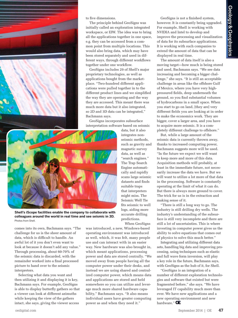
Shell’s iScope facilities enable the company to collaborate with ered based on the same data. Together, accurate drilling industry’s understanding of the subsur- colleagues around the world in real time and see seismic in 3D. the two discoveries added more than predictions. face is still very incomplete and there are
Photos from Shell.
150MMboe to Shell’s resources. When GeoSigns still a lot of uncertainties. This is where “The discoveries were clearly attrib- comes into its own, Bachmann says. “The was introduced, a new, Windows-based investing in computer power gives us the uted to the improved imaging and inter- challenge for us is the sheer amount of operating environment was introduced ability to solve equations that comes out pretation capability,” Bachmann says. data, which is diffcult to handle. An as well, which, it was felt, many people of physics to solve this much better.”
Two specifc areas helped. First, the use awful lot of it you don’t even want to use and can interact with in an easier Integrating and utilizing different data of wide azimuth seismic. Now common look at because it doesn’t add any value.” way. New hardware was also brought in, sets, handling big data and improving pro- practice and widely used, it was not so at Through processing, about 60-70% of which meant applications, processing cessing, using techniques such as elastic the time Shell drilled Deimos. “Shell was the seismic data is discarded, with the power and data are stored centrally. “We and full wave form inversion, will play one of the frst,” Bachmann says. “We remainder worked into a fnal processed moved away from people having all the a key role in the future, Bachmann says, used ocean bottom seismic so you can picture to hand over to the seismic computer power under their desks, and with GeoSigns as the hub of it, for Shell. record the waves from the seismic and interpreters. instead we are using shared and central- “GeoSigns is an integration of a avoid disturbance, and having the experi- Selecting what data you want and ized computer power, which means data number of different exploration technolo- ence of how to do that helped.” then utilizing it and displaying it is key, and applications are stored and held gies and software that existed but were
The second issue is handling the Bachmann says. For example, GeoSigns somewhere so you can utilize and lever- fragmented before,” she says. “We have “enormous” amount of data received, is able to display butterfy gathers so that age much more shared hardware capa- leveraged IT capability much more than processing it properly and interpret- a viewer can look at different azimuths bility,” Bachmann says. “It also means ever. We have new applications and a ing it correctly using high-performance while keeping the view of the gathers individual users have greater computing new operating environment and new computer power. This is where GeoSigns intact, she says, giving the viewer access power as and when they need it.” hardware.” oedigital.com September 2014 | OE 47 046_OE0914_G&G_Shell.indd 47 8/21/14 3:28 PM