
Page 40: of Marine Technology Magazine (April 2005)
Read this page in Pdf, Flash or Html5 edition of April 2005 Marine Technology Magazine
 39
39
 41
41
Prepared for Commissioner Ronald H. Labelle, Department of Public Infrastructure, New Bedford, Massachusetts
This report provides a volume assessment on the five ponds: Assawompset, Pocksha, Little Quittacas, Long, and Great Quittacas located within the towns of Lakeville,
Rochester, and Middleboro in southeastern
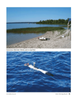
Massachusetts. A survey was conducted to collect the water depth levels throughout each of the aforementioned ponds. This data was gathered using state of the art autonomous underwater vehicles (AUV's), and the infor- mation processed through existing software augmented with a toolbox of custom utilities. This testing was com- pleted over the course of the summer and early fall of 2008. Project funding was through the Public
Infrastructure Department of the City of New Bedford; the UMass Dartmouth Advanced Technology and
Manufacturing Center (ATMC) headed the effort with resources and assistance from OceanServer Technologies,
YSI Environmental, Naval Undersea Warfare Center, and key personnel from the City of New Bedford. The basic goals of this effort was to improve information with regard to the bottom contours of the 5 pond system, pro- vide data in an electronic format compatible with the existing GIS system in use for the City of New Bedford, and finally, provide an overall volume estimate of the pond system to aid in economic development decisions.
The origin of this project was based on need and oppor- tunity. The city of New Bedford enjoys a large and pris- tine five-pond system as a supply source for the cities water. Any information related to the depth and bottom contour of the ponds was obtained in the late 19th centu- ry. Current information as to the volume of the ponds would be valuable in making decisions around economic development and system capacity. The University of
Massachusetts Dartmouth - Advanced Technology and
Manufacturing Center has had on-going research working with OceanServer, YSI, SAIC, and the Navy using small man-portable AUV's. This technology would offer a cost effective method to obtain accurate up to date informa- tion on the pond system at a level not previously possible.
An agreement was reached where the ATMC would conduct a series of pond surveys during a three-month period in the summer of 2008. Data would be collected using the AUV technologies mentioned above and analy- sis of the results would be done using a combination of existing and custom developed software tools. The surveys were conducted in a period between May and October of 2008 using various numbers of vehicles depending on the pond size and mission requirements as follows: Little
Quittacas - May 12th - three vehicles, Great Quittacas -
August 7th - three vehicles, Assawompsett - August 21st - three vehicles, also obtained some of northern Pocksha,
Pocksha - September 19th - one vehicle, and Long -
October 10th - three vehicles.
The survey teams were made up of a combination of
ATMC staff and interns supplemented with personnel from OceanServer, YSI and US Naval personnel from
NUWC of Newport all of which offered AUV operational field experience. Various combinations of these personnel were utilized on each of the surveys. In all forty-nine sur- vey hours, fourteen AUVs were utilized resulting in 182,604 bathymetry readings.
The methodology used in this assessment makes use of the Iver2 AUV's which provide tens of thousands of data sampling points per pond, compared to sub one-hundred sampling points as used in the manual depth hydrograph- ic survey performed over a century ago. Modern GIS interpolation techniques provide an evaluation of each pond's bathymetric features by creating a high-resolution assessment of the pond's geometric characteristics. In doing so, the volume calculation techniques are more accurate than traditional methods, and a confident assess- ment is established. Prior to the development of this tech- nology, updating bathymetry data required hundreds of manually obtained depth readings at a huge labor cost with results far less accurate than what has been accom- plished here. This is one of the most significant reasons that this data has not been updated since the eighteen hundreds. 40 MTR April 2009
New Bedford Ponds
Bathymetry
MTR#3 (34-49).qxd 3/27/2009 2:31 PM Page 40