Page 35: of Marine Technology Magazine (January 2007)
Seafloor Engineering
Read this page in Pdf, Flash or Html5 edition of January 2007 Marine Technology Magazine
(OMSFC). These data form the basis for environ- mental assessments to measure seasonal variations associated with monsoon perturbation. The array was positioned to intercept signals from any release from the Arabian Gulf shipping traffic, as well as to monitor parameters essential to water quality assess- ments meaningful to fisheries (salinity, temperature, oxygen, etc.). It provides detailed information on water motion and density; both are critical to the modeling and prediction of spill behavior.
Four seabed nodes are connected to base arrays containing the full suite of sensors mentioned above. A fiber optic cable connects the nodes, and it leaves the water at Abu Bakara, where the data col- lection, storage and early analyses on the health and performance of the system is constantly monitored.
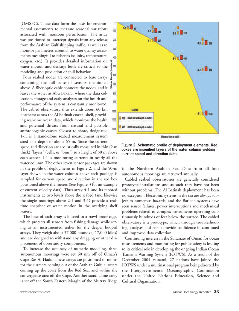
The cabled observatory thus extends about 60 km northeast across the Al Batinah coastal shelf, provid- ing real-time ocean data, which monitors the health and potential threats from natural and possible anthropogenic causes. Closest to shore, designated 1-1, is a stand-alone seabed measurement system sited at a depth of about 65 m. Since the current speed and direction are acoustically measured in thin (2 m thick) "layers" (cells, or "bins") to a height of 50 m above each sensor, 1-1 is monitoring currents in nearly all the water column. The other seven sensor packages are shown in the profile of deployments in Figure 2, and the 50-m layer shown in the water column above each package is sampled for current speed and direction in the red box positioned above the meters (See Figure 3 for an example of current velocity data). Thus array 4-1 and its moored instruments at two levels above the seabed (and likewise the single moorings above 2-1 and 3-1) provide a real- time snapshot of water motion in the overlying shelf waters.
The base of each array is housed in a trawl-proof cage, which protects all sensors from fishing damage while act- ing as an instrumented tether for the deeper buoyed arrays. They weigh about 37,000 pounds (~17,000 kilos) and are designed to withstand any dragging or other dis- placement of observatory components.
To increase the accuracy of numeric modeling, three autonomous moorings were set 60 nm off of Oman's
Cape Ras Al Hadd. These arrays are positioned to moni- tor the currents coming out of the Arabian Gulf, currents coming up the coast from the Red Sea, and within the convergence area off the Cape. Another stand-alone array is set off the South Eastern Margin of the Murray Ridge in the Northern Arabian Sea. Data from all four autonomous moorings are retrieved annually.
Cabled seabed observatories are generally considered prototype installations and as such they have not been without problems. The Al Batinah deployment has been no exception. Electronic systems in the sea are always sub- ject to numerous hazards, and the Batinah systems have seen sensor failures, power interruptions and mechanical problems related to complex instruments operating con- tinuously hundreds of feet below the surface. The cabled observatory is a prototype, which through troubleshoot- ing, analyses and repair provide confidence in continued and improved data collection.
Continuing interest in the Sultanate of Oman for ocean measurements and monitoring for public safety is leading to its critical role in developing the ongoing Indian Ocean
Tsunami Warning System (IOTWS). As a result of the
December 2004 tsunami, 27 nations have joined the
IOTWS under a multinational program being directed by the Intergovernmental Oceanographic Commission under the United Nations Education, Science and
Cultural Organization. www.seadiscovery.com Marine Technology Reporter 35
Figure 2. Schematic profile of deployment elements. Red boxes are insonified layers of the water column yielding current speed and direction data.
MTR#1 (33-48).qxd 1/11/2007 4:12 PM Page 35

 34
34

 36
36
