
Page 72: of Marine Technology Magazine (March 2012)
Subsea Vehicle Report – Unmanned Underwater Systems
Read this page in Pdf, Flash or Html5 edition of March 2012 Marine Technology Magazine
 71
71
 73
73
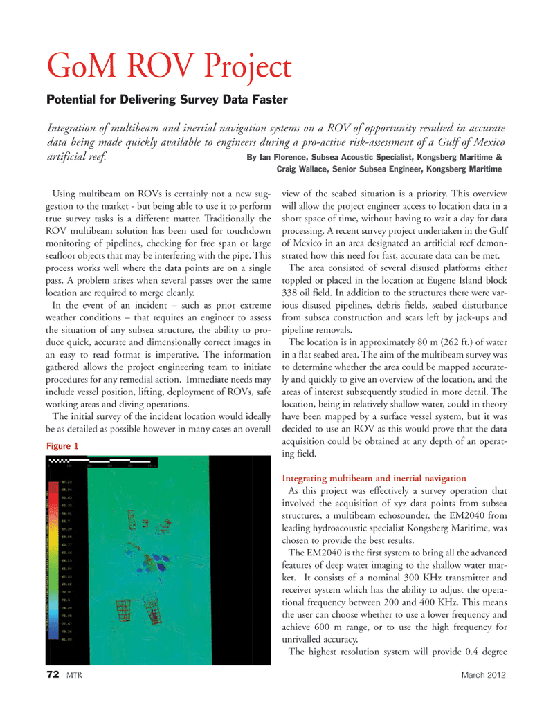
72MTRMarch 2012 Using multibeam on ROVs is certainly not a new sug- gestion to the market - but being able to use it to perform true survey tasks is a different matter. Traditionally the ROV multibeam solution has been used for touchdown monitoring of pipelines, checking for free span or large seafloor objects that may be interfering with the pipe. This process works well where the data points are on a single pass. A problem arises when several passes over the same location are required to merge cleanly. In the event of an incident ? such as prior extreme weather conditions ? that requires an engineer to assess the situation of any subsea structure, the ability to pro- duce quick, accurate and dimensionally correct images in an easy to read format is imperative. The information gathered allows the project engineering team to initiate procedures for any remedial action. Immediate needs may include vessel position, lifting, deployment of ROVs, safe working areas and diving operations. The initial survey of the incident location would ideally be as detailed as possible however in many cases an overall view of the seabed situation is a priority. This overview will allow the project engineer access to location data in a short space of time, without having to wait a day for data processing. A recent survey project undertaken in the Gulf of Mexico in an area designated an artificial reef demon- strated how this need for fast, accurate data can be met. The area consisted of several disused platforms either toppled or placed in the location at Eugene Island block 338 oil field. In addition to the structures there were var- ious disused pipelines, debris fields, seabed disturbancefrom subsea construction and scars left by jack-ups and pipeline removals. The location is in approximately 80 m (262 ft.) of water in a flat seabed area. The aim of the multibeam survey was to determine whether the area could be mapped accurate- ly and quickly to give an overview of the location, and the areas of interest subsequently studied in more detail. The location, being in relatively shallow water, could in theory have been mapped by a surface vessel system, but it was decided to use an ROV as this would prove that the data acquisition could be obtained at any depth of an operat-ing field. Integrating multibeam and inertial navigation As this project was effectively a survey operation that involved the acquisition of xyz data points from subsea structures, a multibeam echosounder, the EM2040 from leading hydroacoustic specialist Kongsberg Maritime, was chosen to provide the best results. The EM2040 is the first system to bring all the advanced features of deep water imaging to the shallow water mar- ket. It consists of a nominal 300 KHz transmitter and receiver system which has the ability to adjust the opera- tional frequency between 200 and 400 KHz. This means the user can choose whether to use a lower frequency and achieve 600 m range, or to use the high frequency for unrivalled accuracy. The highest resolution system will provide 0.4 degree GoM ROV Project Potential for Delivering Survey Data FasterIntegration of multibeam and inertial navigation systems on a ROV of opportunity resulted in accurate data being made quickly available to engineers during a pro-active risk-assessment of a Gulf of Mexico artificial reef. By Ian Florence, Subsea Acoustic Specialist, Kongsberg Maritime & Craig Wallace, Senior Subsea Engineer, Kongsberg Maritime Figure 1 MTR#2 (66-81):MTR Layouts 2/22/2012 10:13 AM Page 72