
Page 16: of Marine Technology Magazine (November 2012)
Fresh Water Monitoring & Sensors
Read this page in Pdf, Flash or Html5 edition of November 2012 Marine Technology Magazine
 15
15
 17
17
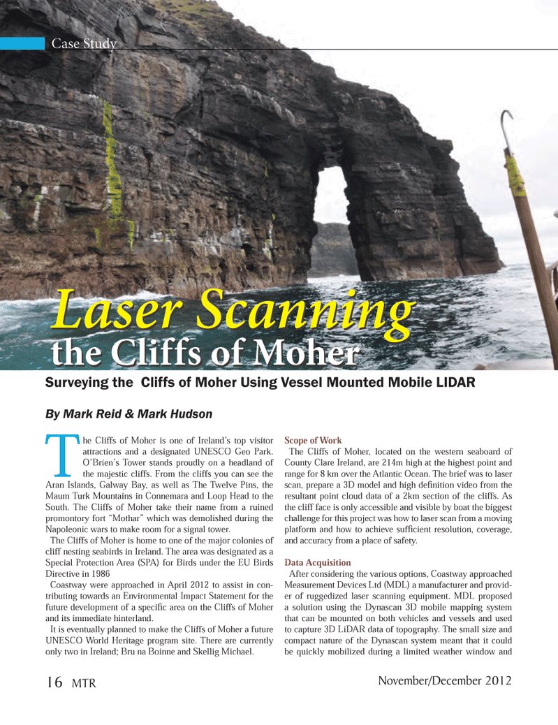
Case Study The Cliffs of Moher is one of Ireland?s top visitor attractions and a designated UNESCO Geo Park. O?Brien?s Tower stands proudly on a headland of the majestic cliffs. From the cliffs you can see the Aran Islands, Galway Bay, as well as The Twelve Pins, the Maum Turk Mountains in Connemara and Loop Head to the South. The Cliffs of Moher take their name from a ruined promontory fort ?Mothar? which was demolished during the Napoleonic wars to make room for a signal tower. The Cliffs of Moher is home to one of the major colonies of cliff nesting seabirds in Ireland. The area was designated as a Special Protection Area (SPA) for Birds under the EU Birds Directive in 1986 Coastway were approached in April 2012 to assist in con- tributing towards an Environmental Impact Statement for the future development of a speci c area on the Cliffs of Moher and its immediate hinterland. It is eventually planned to make the Cliffs of Moher a future UNESCO World Heritage program site. There are currently only two in Ireland; Bru na Boinne and Skellig Michael. Scope of Work The Cliffs of Moher, located on the western seaboard of County Clare Ireland, are 214m high at the highest point and range for 8 km over the Atlantic Ocean. The brief was to laser scan, prepare a 3D model and high de nition video from the resultant point cloud data of a 2km section of the cliffs. As the cliff face is only accessible and visible by boat the biggest challenge for this project was how to laser scan from a moving platform and how to achieve suf cient resolution, coverage, and accuracy from a place of safety. Data AcquisitionAfter considering the various options, Coastway approached Measurement Devices Ltd (MDL) a manufacturer and provid- er of ruggedized laser scanning equipment. MDL proposed a solution using the Dynascan 3D mobile mapping system that can be mounted on both vehicles and vessels and used to capture 3D LiDAR data of topography. The small size and compact nature of the Dynascan system meant that it could be quickly mobilized during a limited weather window and Laser Scanning the Cliffs of Moher Laser Scanning the Cliffs of Moher Surveying the Cliffs of Moher Using Vessel Mounted Mobile LIDAR By Mark Reid & Mark Hudson 16 MTRNovember/December 2012MTR #9 (1-17).indd 16MTR #9 (1-17).indd 1611/29/2012 10:18:22 AM11/29/2012 10:18:22 AM