Page 22: of Marine Technology Magazine (October 2013)
Subsea Defense
Read this page in Pdf, Flash or Html5 edition of October 2013 Marine Technology Magazine
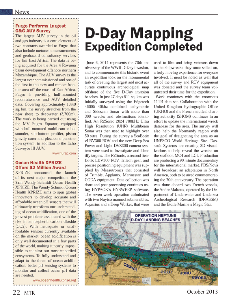
News June 6, 2014 represents the 70th an-niversary of the WWII D-Day invasion, and to commemorate this historic event an expedition took on the monumental task of creating the largest and most ac- curate continuous archeological map offshore of the Þ ve D-Day invasion beaches. In just 27 days 511 sq. km was initially surveyed using the Edgetech 46005 40khz combined bathymetric and Sidescan Sonar with more than 300 wrecks and obstructions identi-Þ ed. An R2Sonic 2024 700kHz Ultra High Resolution (UHR) Multibeam Sonar was then used to highlight over 50 sites. During the survey a SeaBotix vLBV300 ROV and the new Deep Sea Power and Light DVS300 camera sys- tem were used to investigate and iden- tify targets. The R2Sonic, a second Sea- Botix LBV300 ROV, Tritech gear, and precise positioning equipment was sup- plied by Measutronics that consisted of Trimble, Applanix, Marinestar, and CODA equipment. Data collection was done and post processing continues us-ing HYPACKÕs HYSWEEP software. The seven week operation culminated with two Nuytco manned submersibles, Aquarius and a Deep Worker, that were used to Þ lm and bring veterans down to the shipwrecks they once sailed on, a truly moving experience for everyone involved. It must be noted as well that all of the survey and ROV equipment was donated and the survey team vol- unteered their time for the expedition. Work continues with the enormous 11TB data set. Collaboration with the United Kingdom Hydrographic OfÞ ce (UKHO) and the French nautical chart-ing authority (SHOM) continues in an effort to update the international wreck database for the area. The survey will also help the Normandy region with the goal of designating the area as an UNESCO World Heritage Site. Das- sault Systems are creating 3D visual-izations to help reveal the wrecks on the seaß oor. MC4 and LCL Production are producing a 90 minute documentary for the international market. PBS/Nova will broadcast an adaptation in North America, both to be aired commemorat-ing the 70th anniversary. The operation was done aboard two French vessels, the Andre Malraux, operated by the De- partment of Underwater and Undersea Archeological Research (DRASSM) and the Etoile MarineÕs Magic Star. Furgo Performs Largest O&G AUV Survey The largest AUV survey in the oil and gas industry is a core element of two contracts awarded to Fugro that also include metocean measurements and geohazard consultancy services for Eni East Africa. The data is be- ing acquired for the Area 4 Rovuma basin development offshore northern Mozambique. The AUV survey is the largest ever commissioned and one of the Þ rst in this new and remote fron- tier area off the coast of East Africa. Fugro is providing hull-mounted reconnaissance and AUV detailed data. Covering approximately 1,440 sq. km, the survey stretches from the near shore to deepwater (2,700m). The work is being carried out using the MV Fugro Equator, equipped with hull-mounted multibeam echo-sounder, sub-bottom proÞ ler, piston gravity corer and piezocone penetra- tion system, in addition to the Echo Surveyor III AUV. www.furgo.com Ocean Health XPRIZE Offers $2 Million Award XPRIZE announced the launch of its next major competition: the $2m Wendy Schmidt Ocean Health XPRIZE. The Wendy Schmidt Ocean Health XPRIZE aims to spur global innovators to develop accurate and affordable ocean pH sensors that will ultimately transform our understand-ing of ocean acidiÞ cation, one of the gravest problems associated with the rise in atmospheric carbon dioxide (CO2). With inadequate or unaf- fordable sensors currently available on the market, ocean acidiÞ cation is only well documented in a few parts of the world, making it nearly impos- sible to monitor our most imperiled ecosystems. To fully understand and adapt to the threat of ocean acidiÞ -cation, better pH sensing systems to monitor and collect ocean pH data are needed.www.oceanhealth.xprize.org D-Day Mapping Expedition Completed22 MTROctober 2013MTR #8 (18-33).indd 22MTR #8 (18-33).indd 2210/16/2013 9:23:10 AM10/16/2013 9:23:10 AM

 21
21

 23
23
