Page 44: of Marine Technology Magazine (October 2013)
Subsea Defense
Read this page in Pdf, Flash or Html5 edition of October 2013 Marine Technology Magazine
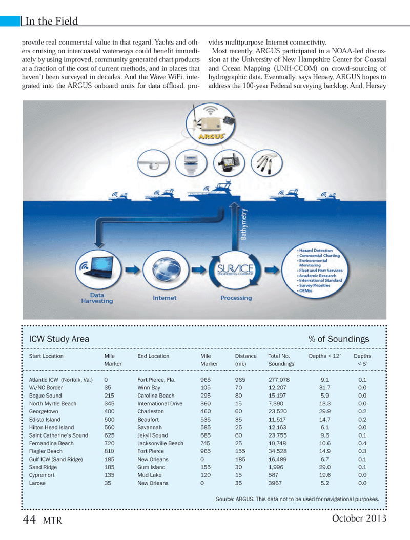
provide real commercial value in that regard. Yachts and oth- ers cruising on intercoastal waterways could beneÞ t immedi- ately by using improved, community generated chart products at a fraction of the cost of current methods, and in places that havenÕt been surveyed in decades. And the Wave WiFi, inte- grated into the ARGUS onboard units for data ofß oad, pro- vides multipurpose Internet connectivity. Most recently, ARGUS participated in a NOAA-led discus- sion at the University of New Hampshire Center for Coastal and Ocean Mapping (UNH-CCOM) on crowd-sourcing of hydrographic data. Eventually, says Hersey, ARGUS hopes to address the 100-year Federal surveying backlog. And, Hersey In the Field ICW Study Area % of Soundings Start Location Mile End Location Mile Distance Total No. Depths < 12? Depths Marker Marker (mi.) Soundings < 6?Atlantic ICW (Norfolk, Va.) 0 Fort Pierce, Fla. 965 965 277,078 9.1 0.1 VA/NC Border 35 Winn Bay 105 70 12,207 31.7 0.0 Bogue Sound 215 Carolina Beach 295 80 15,197 5.9 0.0 North Myrtle Beach 345 International Drive 360 15 7,390 13.3 0.0 Georgetown 400 Charleston 460 60 23,520 29.9 0.2 Edisto Island 500 Beaufort 535 35 11,517 14.7 0.2 Hilton Head Island 560 Savannah 585 25 12,163 6.1 0.0 Saint Catherine?s Sound 625 Jekyll Sound 685 60 23,755 9.6 0.1 Fernandina Beach 720 Jacksonville Beach 745 25 10,748 10.6 0.4 Flagler Beach 810 Fort Pierce 965 155 34,528 14.9 0.3 Gulf ICW (Sand Ridge) 185 New Orleans 0 185 16,489 6.7 0.1 Sand Ridge 185 Gum Island 155 30 1,996 29.0 0.1 Cypremort 135 Mud Lake 120 15 587 19.6 0.0 Larose 35 New Orleans 0 35 3967 5.2 0.0Source: ARGUS. This data not to be used for navigational purposes. October 201344 MTRMTR #8 (34-49).indd 44MTR #8 (34-49).indd 4410/15/2013 4:41:40 PM10/15/2013 4:41:40 PM

 43
43

 45
45
