
Page 58: of Marine Technology Magazine (March 2014)
Instrumentation: Measurement, Process & Analysis
Read this page in Pdf, Flash or Html5 edition of March 2014 Marine Technology Magazine
 57
57
 59
59
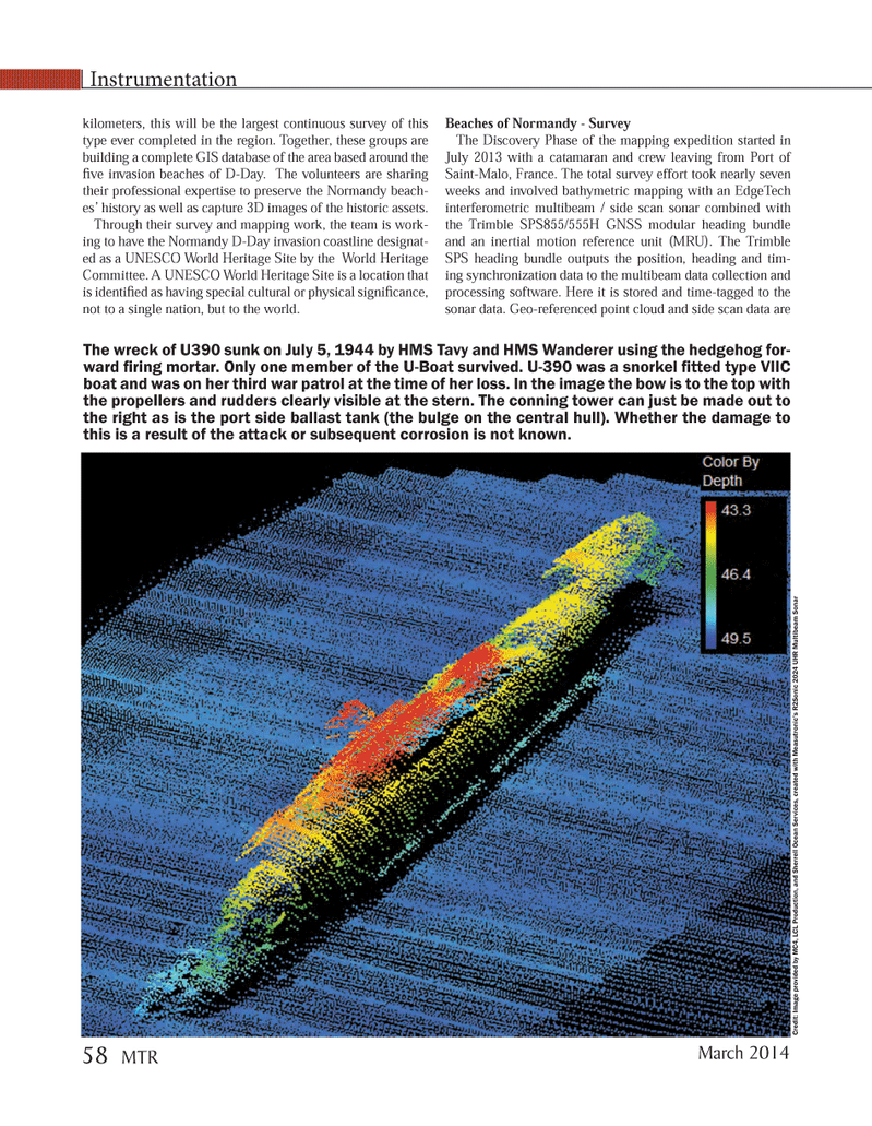
kilometers, this will be the largest continuous survey of this type ever completed in the region. Together, these groups are building a complete GIS database of the area based around the Þ ve invasion beaches of D-Day. The volunteers are sharing their professional expertise to preserve the Normandy beach- esÕ history as well as capture 3D images of the historic assets. Through their survey and mapping work, the team is work- ing to have the Normandy D-Day invasion coastline designat- ed as a UNESCO World Heritage Site by the World Heritage Committee. A UNESCO World Heritage Site is a location that is identiÞ ed as having special cultural or physical signiÞ cance, not to a single nation, but to the world. Beaches of Normandy - Survey The Discovery Phase of the mapping expedition started in July 2013 with a catamaran and crew leaving from Port of Saint-Malo, France. The total survey effort took nearly seven weeks and involved bathymetric mapping with an EdgeTech interferometric multibeam / side scan sonar combined with the Trimble SPS855/555H GNSS modular heading bundle and an inertial motion reference unit (MRU). The Trimble SPS heading bundle outputs the position, heading and tim- ing synchronization data to the multibeam data collection and processing software. Here it is stored and time-tagged to the sonar data. Geo-referenced point cloud and side scan data are Instrumentation Credit: Image provided by MC4, LCL Production, and Sherrell Ocean Services, created with Measutronic?s R2Sonic 2024 UHR Multibeam Sonar The wreck of U390 sunk on July 5, 1944 by HMS Tavy and HMS Wanderer using the hedgehog for- ward Þ ring mortar. Only one member of the U-Boat survived. U-390 was a snorkel Þ tted type VIIC boat and was on her third war patrol at the time of her loss. In the image the bow is to the top with the propellers and rudders clearly visible at the stern. The conning tower can just be made out to the right as is the port side ballast tank (the bulge on the central hull). Whether the damage to this is a result of the attack or subsequent corrosion is not known. March 2014 58 MTRMTR #2 (50-65).indd 58MTR #2 (50-65).indd 582/21/2014 11:30:32 AM2/21/2014 11:30:32 AM