
Page 48: of Marine Technology Magazine (November 2014)
Fresh Water Monitoring & Senors
Read this page in Pdf, Flash or Html5 edition of November 2014 Marine Technology Magazine
 47
47
 49
49
These rapid changes are very easy to 2012. Nitrate sensors on small streams The following information was extract- miss with traditional water-quality mon- and large rivers throughout the Missis- ed directly from the U.S. Geological itoring approaches. sippi River basin are improving our abil- Survey (USGS) report. For full details
However, hourly information on nitrate ity track where the pulses are coming and references, please visit: levels improves the accuracy and reduc- from and forecast when they will arrive http://ca.water.usgs.gov/pubs/ es the uncertainty in estimating nitrate at the Gulf. 2014/PellerinEtAl2014.pdf loads to the Gulf of Mexico, especially The USGS, in cooperation with nu- during drought and ? ood years. merous local, state, and other federal Abstract –
This high frequency data also provides agencies, currently operates over 100 Accurately quantifying nitrate (NO ) 3 new insights into timing and magnitude real-time nitrate sensors across the Na- loading from the Mississippi River is of nitrate ? ushing from soils during wet tion. important for predicting summer hy- and dry conditions. Real-time nitrate monitoring is sup- poxia in the Gulf of Mexico and target-
For instance, the high frequency data ported by the USGS National Stream ing nutrient reduction within the basin. revealed high nitrate concentrations dur- Quality Accounting Network, Coopera- Loads have historically been modeled ing the spring and early summer of both tive Water Program, and the National with regression-based techniques, but 2013 and 2014 following the drought of Water-Quality Assessment Program. recent advances with high frequency
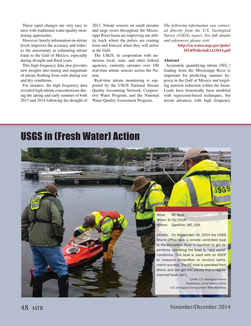
USGS in (Fresh Water) Action
What: RC Boat
When: 9/16/2014
Where: Gardiner, ME, USA
Details: On September 16, 2014 the USGS
Maine Of? ce took a remote controlled boat to the Kennebec River in Gardiner to get ex- perience operating the boat in “real world” conditions. This boat is used with an ADCP to measure stream? ow or conduct bathy- metric surveys. The RC boat is operated from shore, and can get into places that a regular manned boat can’t.
Credit: U.S. Geological Survey
Department of the Interior/USGS
U.S. Geological Survey/photo: Mike Beardsley
November/December 2014 48
MTR
MTR #9 (34-49).indd 48 MTR #9 (34-49).indd 48 12/9/2014 10:59:49 AM12/9/2014 10:59:49 AM