Page 39: of Marine Technology Magazine (April 2015)
Offshore Energy Annual
Read this page in Pdf, Flash or Html5 edition of April 2015 Marine Technology Magazine
 38
38
 40
40
SAS uses sophisticated signal processing techniques to com- data quality, better resolution and a pathway to a deliverable pare the multiple observations of the same area of sea? oor to of more integrated data fusion surveys.
calculate its depth. The image resolution of the seabed is sig- In addition to re? ectivity images, SAS can produce highly ni? cantly increased – often by an order of magnitude - com- detailed topographic maps of the sea? oor by detecting the an- pared to conventional sidescan sonar. In essence, the resolution gle of arrival of seabed echoes coming from a given range bin. becomes independent of range and of frequency. SAS systems In a con? guration known as Interferometric SAS (INSAS), can achieve an image and bathymetry resolution of a few cen- two vertically separated arrays produce bathymetric maps that timeters even in very deep waters. are exactly co-registered with the corresponding SAS images.
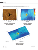
Figure 1 shows a simultaneously co-registered INSAS re- This combination of synthetic aperture processing and inter- ? ectivity image and 3D bathymetry of discarded automobiles ferometry solves the problems of limited resolution and cov- in Halifax, Nova Scotia collected during sea trials with the erage rates encountered with conventional swath bathymetric
Defence Research Development Canada. sonars and multibeam echo sounders. When the InSAS bathy-
While SAS has been around for over a decade, military ap- metric resolution approaches that of the corresponding SAS plications such as naval mine countermeasures have been its image, it becomes possible to overlay the re? ectivity and to- major development driver. However, SAS is a multi-use tech- pography to create a true 3D picture of objects on the seabed. nology with great potential for offshore oil and gas survey- The use of INSAS systems – such as the AquaPix system ing, hydrographic surveys, underwater archaeology, benthic produced by Kraken Sonar Inc. - is a promising tool for habitat mapping and deep sea mining. The viability of SAS achieving these objectives in both very shallow water and as a high resolution survey sensor seems a logical progres- deep water environments. AquaPix® produces real-time, high sion for the industry with the additional bene? ts of increased resolution, three dimensional (3D) digital terrain models of
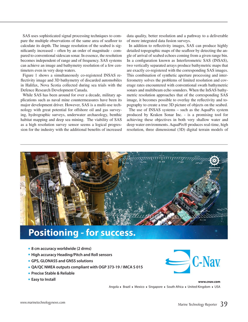
Positioning - for success.
8 cm accuracy worldwide (2 drms)
High accuracy Heading/Pitch and Roll sensors
GPS, GLONASS and GNSS solutions
QA/QC NMEA outputs compliant with OGP 373-19 / IMCA S 015
Precise Stable & Reliable
Easy to Install www.cnav.com
Angola Brazil Mexico Singapore South Africa United Kingdom USA www.marinetechnologynews.com
Marine Technology Reporter 39
MTR #3 (34-49).indd 39 MTR #3 (34-49).indd 39 4/6/2015 10:06:37 AM4/6/2015 10:06:37 AM