
Page 76: of Marine Technology Magazine (March 2017)
Oceanographic Instrumentation: Measurement, Process & Analysis
Read this page in Pdf, Flash or Html5 edition of March 2017 Marine Technology Magazine
 75
75
 77
77
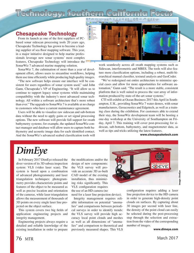
Chesapeake Technology
From its launch as one of the ? rst suppliers of PC- based sonar sidescan processing tools 20 years ago,
Chesapeake Technology has grown to become a lead- ing supplier of sea ? oor mapping software. This year, in a major initiative designed to help marine profes- sionals leverage new sonar systems’ most complex
Image: Chesapeake Technology features, Chesapeake Technology will introduce the work seamlessly across all swath mapping systems such as
SonarWiz 7 advanced marine mapping solution.
Sidescan, interferometric and MBES. The tools will also fea-
SonarWiz 7, the culmination of more than a year of devel- opment effort, allows users to streamline work? ows, helping ture more classi? cation options, including a robust, multi-hi- erarchical manual classi? er, textural analysis and GeoCoder.
them use time ef? ciently while producing high quality images. “We’ve redesigned out entire architecture to minimize spe- “The new software helps ensure our interface will be con- sistent for users regardless of sonar system used,” said John cial cases and allow for more opportunities for software au-
Gann, Chesapeake’s VP of Engineering. “It will allow us to tomation,” Gann said. “The result is a more stable, consistent continue to support legacy sonar systems while maintaining platform that is well suited to process the vast array of infor- mation produced by state-of-the-art sonar systems.” compatibility with the industry’s most advanced sonar tech-
CTI will exhibit at Ocean Business 2017 this April in South- nology. All within a software architecture that’s more robust ampton, U.K., providing SonarWiz 7 water demos, with sonar than ever.” The upgrade to SonarWiz 7 is available at no charge manufacturers, Geoacoustics and Edgetech, as well as a train- to customers who have a current maintenance agreement.
Users will be able to visualize raw sidescan and sub-bottom ing class during the exhibition. For customers able to extend data without the need to apply gains or set signal processing their stay, the SonarWiz development team will be hosting a options. The new software will provide full support for swath one-day workshop at the University of Southampton on Fri- day, April 7. This training will cover post-processing for si- bathymetry systems; for example, the updated SonarWiz con- descan, sub-bottom, bathymetry, and magnetometer data, as tact manager and database will allow users to capture both ba- thymetry and acoustic image data for each identi? ed contact. well as tips and tricks utilizing the latest features. www.chesapeaketech.com
And the SonarWiz’s advanced seabed classi? cation tools will
DimEye
In February 2017 DimEye released the the modi? cations and/or the diver version of its 3D subsea inspection design of new components: system: VLS (video laser scan). The the VLS survey will pro- system is based upon a combination vide an accurate 3D as-built of advanced photogrammetry and laser CAD model of the existing triangulation techniques: photogram- installation, thus minimiz- metry provides characteristic points and ing risks signi? cantly. This
Image: DimEye features of the object to be measured as VLS con? guration requires well as precise location and orientation the use of an HD camera (no con? guration requires adding a laser of the cameras, while laser triangulation need for a laser line projection device). line projection device to the HD camera allows the measurement of thousands of Integrity management requires reli- in order to generate high-density point 3D points on every single laser line pro- able information on potential “anoma- clouds on surfaces. By capturing about jected on the object surface. lies” and comparisons between periodi- 30 images per second with laser line,
This system covers two big ? elds of cal surveys in order to identify trends: the density of the point cloud can easily application: engineering projects and the VLS survey will provide high ac- be selected during the post-processing integrity management. curacy local point clouds and meshes step through the selection and extrac-
Engineering projects always require a as well as all dimensions of “anoma- tion from the video of the corresponding detailed and reliable knowledge of the lies” and comparison to theoretical and number of images.
existing installation in order to prepare previously measured shapes. This VLS www.dimeye.com
March 2017 76
MTR
MTR #2 (66-80).indd 76 MTR #2 (66-80).indd 76 3/1/2017 10:58:15 AM3/1/2017 10:58:15 AM