Page 34: of Marine Technology Magazine (September 2021)
MTR100: Focus on 100 Leading Companies, People and Innovations in the Subsea Space
Read this page in Pdf, Flash or Html5 edition of September 2021 Marine Technology Magazine
 33
33
 35
35
MTTTTTTTTTTTTTRM M M M M M M M M M M M M M M M M M M M M M M M M M M M MTRRRRRRRRRRRRRRRRRRRRRRRRRRRMTTTTTTTTTTTTTRMTR 100000000000000001111111111111111111111111111100000000000000000000000000000010000000000000000100
Working at the Interface of Exploration and Education
NOAA
By Genene Fisher, PhD & Marlene Kaplan, D.Env.
he National Oceanic and Atmospheric Ad- online, bringing the excitement of ocean exploration and dis- ministration (NOAA) is the only federal coveries into classrooms and homes. The vessel is managed agency with a program dedicated to exploring by the NOAA Of? ce of Marine and Aviation Operations and the deep ocean, closing gaps in our basic under- mission equipment is operated by NOAA in partnership with standing of U.S. deep waters and the sea? oor, the Global Foundation for Ocean Exploration (GFOE).
T and delivering the ocean information needed to strengthen the economy, health, and security of our nation. Inspiring Advancing Technology and engaging the next generation are fundamental to the Okeanos Explorer is also a platform for technology devel- operations of the agency’s ocean exploration program. Mis- opment and in May 2021 it hosted ? eld engineering trials sions aboard NOAA Ship Okeanos Explorer — the only fed- for Woods Hole Oceanographic Institution’s new Orpheus eral vessel dedicated to exploring the deep ocean — include autonomous underwater vehicle (AUV), which was support- mapping, ocean characterization, reconnaissance, advancing ed through the Ocean Exploration Cooperative Institute technology, and educational outreach with an emphasis on (OECI). Designed to withstand pressure down to 11,000 collecting baseline information in never-before-explored meters, it will provide access to some of the deepest parts areas. Characterization involves taking an in-depth look at of our ocean. Integration of a vision-based system for esti- a region or speci? c site and gathering data of the sea? oor, mating relative position developed by NASA’s Jet Propul- sub-bottom, and/or water column. Data are collected using a sion Laboratory, similar to the Terrain-Relative Navigation variety of advanced technologies to explore and characterize system used on the Mars Perseverance rover and Helicopter unknown or poorly known deepwater ocean areas, features, Ingenuity, will allow the AUV to sense its location relative and phenomena at depths ranging from 250 to 6,000 meters. to the sea? oor and avoid hazards, and recognize sea? oor fea-
Expeditions are planned collaboratively, with input from tures that may be of scienti? c interest. partners and stakeholders, enabling broad scienti? c par- NOAA Ocean Exploration is using new autonomous tech- ticipation. Through telepresence technology, scientists and nologies to meet ambitious mapping and exploration goals. students participating in missions primarily remain on shore Through the National Oceanographic Partnership Program and are able to add their expertise to missions no matter (NOPP), a multi-year grant was provided to the Univer- where in the world the ship, or they, are located. Simultane- sity of New Hampshire, Saildrone, and the Monterey Bay ously, public viewers can watch and listen to live expeditions Aquarium Research Institute to test and integrate acoustic and other sensors into a new larger class of uncrewed sur- face vehicles powered by wind and solar power. The 22m
Saildrone Surveyor is designed to collect bathymetry of the
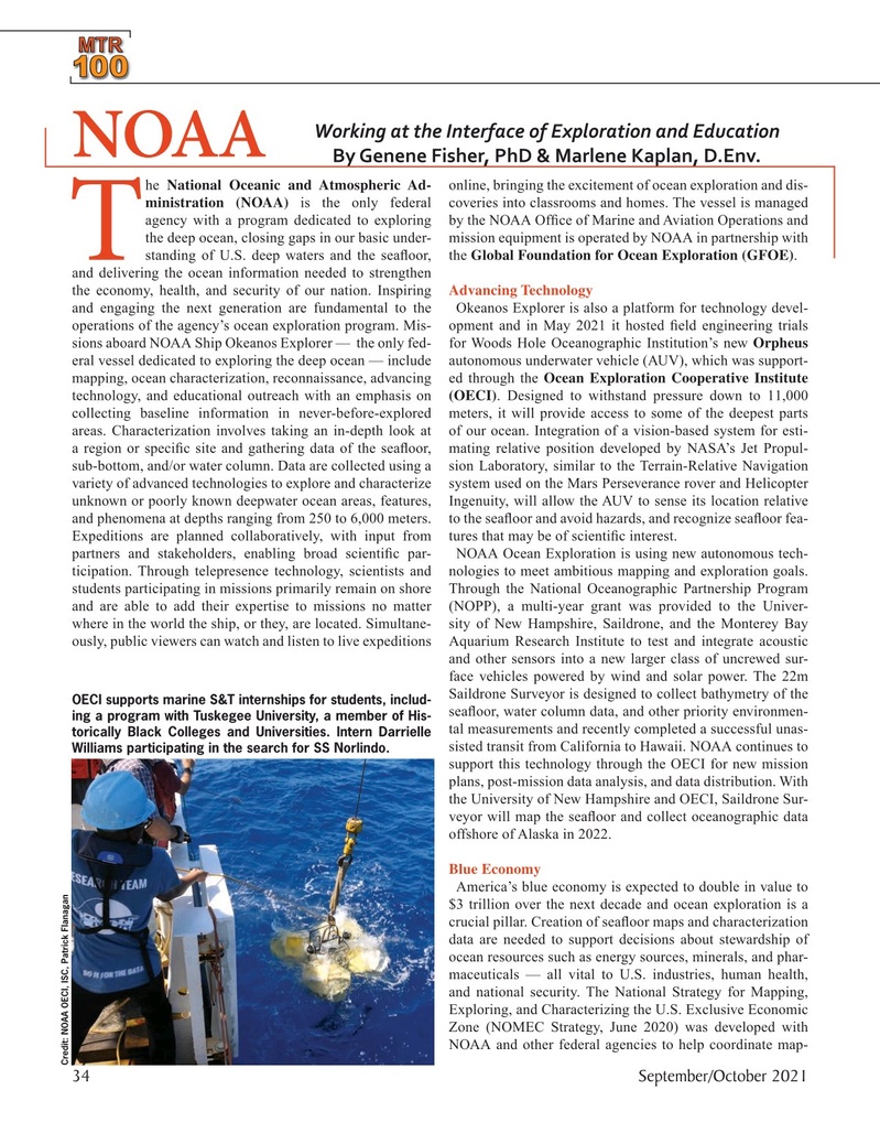
OECI supports marine S&T internships for students, includ- sea? oor, water column data, and other priority environmen- ing a program with Tuskegee University, a member of His- tal measurements and recently completed a successful unas- torically Black Colleges and Universities. Intern Darrielle sisted transit from California to Hawaii. NOAA continues to
Williams participating in the search for SS Norlindo. support this technology through the OECI for new mission plans, post-mission data analysis, and data distribution. With the University of New Hampshire and OECI, Saildrone Sur- veyor will map the sea? oor and collect oceanographic data offshore of Alaska in 2022.
Blue Economy
America’s blue economy is expected to double in value to $3 trillion over the next decade and ocean exploration is a crucial pillar. Creation of sea? oor maps and characterization data are needed to support decisions about stewardship of ocean resources such as energy sources, minerals, and phar- maceuticals — all vital to U.S. industries, human health, and national security. The National Strategy for Mapping,
Exploring, and Characterizing the U.S. Exclusive Economic
Zone (NOMEC Strategy, June 2020) was developed with
NOAA and other federal agencies to help coordinate map-
Credit: NOAA OECI, ISC, Patrick Flanagan 34 September/October 2021
MTR #7 (34-49).indd 34 9/22/2021 9:27:56 AM