
Page 54: of Marine Technology Magazine (Sep/Oct 2021)
MTR100: Focus on 100 Leading Companies, People and Innovations in the Subsea Space
Read this page in Pdf, Flash or Html5 edition of Sep/Oct 2021 Marine Technology Magazine
 53
53
 55
55
MTTTTTTTTTTTTTRM M M M M M M M M M M M M M M M M M M M M M M M M M M M MTRRRRRRRRRRRRRRRRRRRRRRRRRRRMTTTTTTTTTTTTTRMTR 100000000000000001111111111111111111111111111100000000000000000000000000000010000000000000000100
BioConsult SH & HiDef Aerial Surveying https://www.spacewhales.de/
Space tech and AI have combined to enhance the conser-
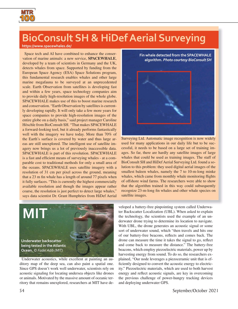
Fin whale detected from the SPACEWHALE vation of marine animals: a new service, SPACEWHALE, algorithm. Photo courtesy BioConsult SH developed by a team of scientists in Germany and the UK, detects whales from space. Supported by funding from the
European Space Agency (ESA) Space Solutions program, this fundamental research enables whales and other large marine megafauna to be surveyed at an unprecedented scale. Earth Observation from satellites is developing fast and within a few years, space technology companies aim to provide daily high-resolution images of the whole globe.
SPACEWHALE makes use of this to boost marine research and conservation. “Earth Observation by satellites is current- ly developing rapidly. It will only take a few more years for space companies to provide high-resolution images of the entire globe on a daily basis,” said project manager Caroline
Höschle from BioConsult SH. “That makes SPACEWHALE a forward-looking tool, but it already performs fantastically well with the imagery we have today. More than 70% of
Surveying Ltd. Automatic image recognition is now widely the Earth’s surface is covered by water and thus large ar- used for many applications in our daily life but to be suc- eas are still unexplored. The intelligent use of satellite im- agery now brings us a lot of previously inaccessible data. cessful, it needs to be based on a large set of training im-
SPACEWHALE is part of this revolution. SPACEWHALE ages. So far, there are hardly any satellite images of large whales that could be used as training images. The staff of is a fast and ef? cient means of surveying whales - at a com- parable cost to traditional methods for only a small area of BioConsult SH and HiDef Aerial Surveying Ltd. found a so- the oceans. SPACEWHALE uses satellite imagery with a lution to this problem: they used digital aerial images of the resolution of 31 cm per pixel across the ground, meaning smallest baleen whales, namely the 7 to 10-m-long minke that a 23 m ? n whale has a length of around 77 pixels when whales, which came from monthly whale monitoring ? ights it fully surfaces. “This is currently the highest commercially of offshore wind farms. The researchers were able to show available resolution and though the images appear rather that the algorithm trained in this way could subsequently coarse, the resolution is just perfect to detect large whales,” recognize 23-m-long ? n whales and other whale species on says data scientist Dr. Grant Humphries from HiDef Aerial satellite images. veloped a battery-free pinpointing system called Underwa- ter Backscatter Localization (UBL). When asked to explain the technology, the scientists used the example of an un-
MIT derwater drone trying to determine its location to navigate.
With UBL, the drone generates an acoustic signal or some sort of underwater sound, which “then travels and hits one of our battery-free beacons, re? ects and comes back. The drone can measure the time it takes the signal to go, re? ect
Underwater backscatter and come back to measure the distance.” The battery-free being tested in the Atlantic beacons, which employ piezoelectric materials, power up by
Ocean. © Fadel Adib (MIT) harvesting energy from sound. To do so, the researchers ex-
Underwater acoustics, while excellent at painting an au- plained, “Our node leverages a piezoceramic unit that is ef- ditory map of the deep sea, can also paint a spatial one. ? ciently designed to convert the acoustic energy to electric-
Since GPS doesn’t work well underwater, scientists rely on ity.” Piezoelectric materials, which are used to both harvest acoustic signaling for locating undersea objects like drones energy and re? ect acoustic signals, are key in overcoming or animals. Motivated by the massive amount of oceanic ter- the previous challenge of power-hungry tracking devices ritory that remains unexplored, researchers at MIT have de- and deploying underwater GPS. 54 September/October 2021
MTR #7 (50-65).indd 54 9/21/2021 11:31:11 AM