Page 60: of Maritime Logistics Professional Magazine (Sep/Oct 2018)
Liner Shipping & Logistics
Read this page in Pdf, Flash or Html5 edition of Sep/Oct 2018 Maritime Logistics Professional Magazine
 59
59
 61
61
SAFETY INSIGHTS
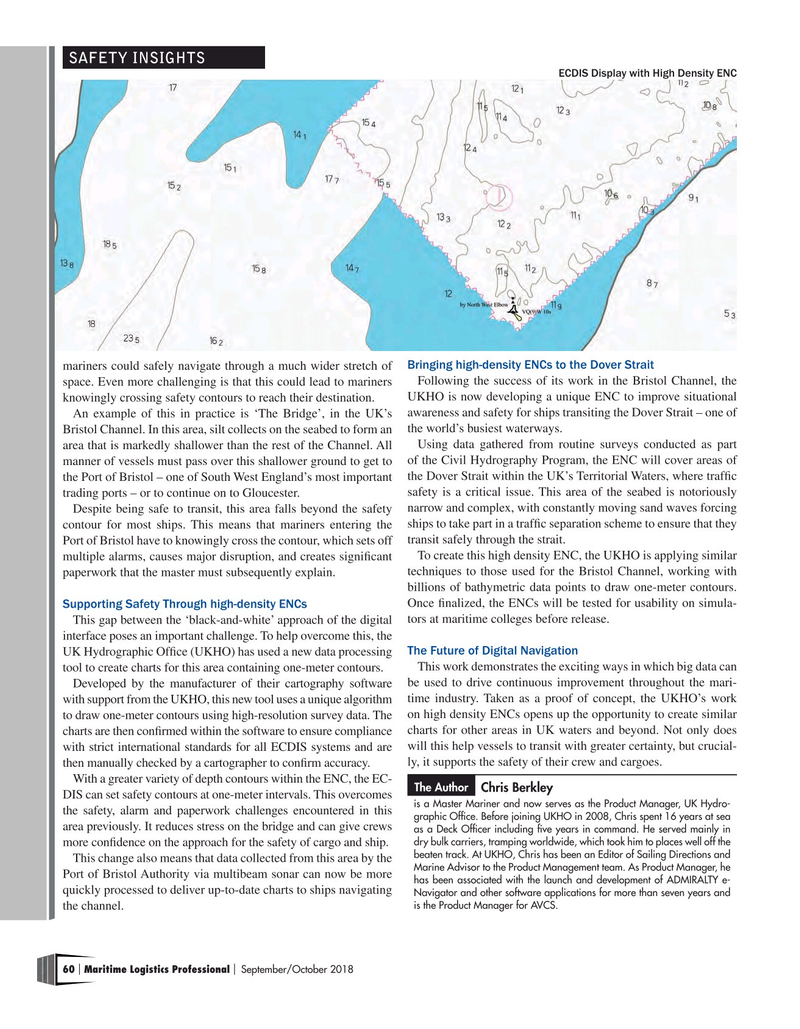
ECDIS Display with High Density ENC mariners could safely navigate through a much wider stretch of Bringing high-density ENCs to the Dover Strait space. Even more challenging is that this could lead to mariners Following the success of its work in the Bristol Channel, the knowingly crossing safety contours to reach their destination. UKHO is now developing a unique ENC to improve situational
An example of this in practice is ‘The Bridge’, in the UK’s awareness and safety for ships transiting the Dover Strait – one of
Bristol Channel. In this area, silt collects on the seabed to form an the world’s busiest waterways.
area that is markedly shallower than the rest of the Channel. All Using data gathered from routine surveys conducted as part manner of vessels must pass over this shallower ground to get to of the Civil Hydrography Program, the ENC will cover areas of the Port of Bristol – one of South West England’s most important the Dover Strait within the UK’s Territorial Waters, where traffc trading ports – or to continue on to Gloucester. safety is a critical issue. This area of the seabed is notoriously
Despite being safe to transit, this area falls beyond the safety narrow and complex, with constantly moving sand waves forcing contour for most ships. This means that mariners entering the ships to take part in a traffc separation scheme to ensure that they
Port of Bristol have to knowingly cross the contour, which sets off transit safely through the strait. multiple alarms, causes major disruption, and creates signifcant To create this high density ENC, the UKHO is applying similar paperwork that the master must subsequently explain. techniques to those used for the Bristol Channel, working with billions of bathymetric data points to draw one-meter contours.
Supporting Safety Through high-density ENCs Once fnalized, the ENCs will be tested for usability on simula-
This gap between the ‘black-and-white’ approach of the digital tors at maritime colleges before release.
interface poses an important challenge. To help overcome this, the
UK Hydrographic Offce (UKHO) has used a new data processing The Future of Digital Navigation tool to create charts for this area containing one-meter contours. This work demonstrates the exciting ways in which big data can
Developed by the manufacturer of their cartography software be used to drive continuous improvement throughout the mari- with support from the UKHO, this new tool uses a unique algorithm time industry. Taken as a proof of concept, the UKHO’s work to draw one-meter contours using high-resolution survey data. The on high density ENCs opens up the opportunity to create similar charts are then confrmed within the software to ensure compliance charts for other areas in UK waters and beyond. Not only does with strict international standards for all ECDIS systems and are will this help vessels to transit with greater certainty, but crucial- then manually checked by a cartographer to confrm accuracy. ly, it supports the safety of their crew and cargoes.
With a greater variety of depth contours within the ENC, the EC-
The Author
Chris Berkley
DIS can set safety contours at one-meter intervals. This overcomes is a Master Mariner and now serves as the Product Manager, UK Hydro- the safety, alarm and paperwork challenges encountered in this graphic Offce. Before joining UKHO in 2008, Chris spent 16 years at sea area previously. It reduces stress on the bridge and can give crews as a Deck Offcer including fve years in command. He served mainly in dry bulk carriers, tramping worldwide, which took him to places well off the more confdence on the approach for the safety of cargo and ship.
beaten track. At UKHO, Chris has been an Editor of Sailing Directions and
This change also means that data collected from this area by the
Marine Advisor to the Product Management team. As Product Manager, he
Port of Bristol Authority via multibeam sonar can now be more has been associated with the launch and development of ADMIRALTY e- quickly processed to deliver up-to-date charts to ships navigating
Navigator and other software applications for more than seven years and is the Product Manager for AVCS.
the channel. 60 Maritime Logistics Professional September/October 2018 | |