Page 22: of Maritime Reporter Magazine (August 1986)
Read this page in Pdf, Flash or Html5 edition of August 1986 Maritime Reporter Magazine
 21
21
 23
23
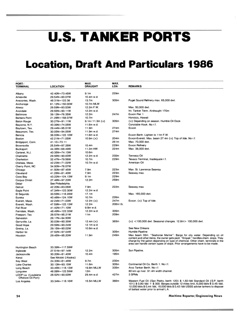
U.S. TANKER PORTS
Location, Draft And Particulars 1986
PORT/ MAX. MAX.
TERMINAL LOCATION DRAUGHT LOA REMARKS
Albany 42.40N—73.45W 9.1m 229m
Amesville 29.54N—90.07W 10.4m w.d.
Anacortes, Wash. 48.31N—122.36 13.7m 305m Puget Sound Refinery max. 65,000 dwt.
Anchorage 61.12N—150.00W 10.7m MLW
Atreco 29.59N—93.53W 12.2m F.W. Max. 50,000 dwt.
Avondale 29.55N—90.11W 12.2m w.d. Int. Tanker Term. Airdraught 170m
Baltimore 39.13N—76.35W 12.2m 247m Exxon Pier 1
Barbers Point 21.28N—158.07W 10.7m Honolulu, Hawaii
Baton Rouge 30.27N—91.11W 9.1m/11.3m (x) 305m (x) Depending on season. Humble Oil Dock
Bayonne, N.Y. 40.39N—74.05W 11,6m w.d. Conotable Hook. No r.f.
Baytown, Tex. 29.44N—95.01 W 11.9m 274m Exxon
Beaumont, Tex. 30.05N—94.05W 11.9m w.d. 274m
Benicia 38.03N—122.10W 11,6m w.d. Exxon Berth. Lighten to 11m F.W.
Boston 42.21N—71 05W 10.9m (x) 204m Exxon-Everett. Max. beam 27.4m (x) Top of tide. No r.f
Bridgeport, Conn. 41.10-73.11 251m Max. 70,000 dwt.
Brownsville 25.54N—97.28W 10.4m 229m Exxon Refinery
Bucksport 44.35N—68.49W 11.3m HW 224m Max. 38,000 dwt.
Carteret, N.J. 40.35N—74.13W 10.6m
Chalmette 29.56N—90.00W 12.2m w.d. 230m Tenneco Oil
Charleston 32.47N—79.56W 10.7m 229m Texaco Terminal, Inadequate r.f.
Chelsea, Mass. 42.23N—71.02W 10.7m w.d. American Oil
Cherry Point, NC 34.00N—76.07W
Chicago 41.50N—87.45W 7.9m 223m Max. St. Lawrence Seaway
Cleveland 41.28N-81.40W 7.9m 223m Seaway max.
Coos Bay 43.22N—124.13W 9.1m 229m
Corpus Christi 27.48N—97.23W 12.2m 259m
Delair See Philadelphia.
Detroit 42.20N—83.05W 7.9m 222m Seaway max
Eagle Point 47.34N—122.30W 12.2m w.d.
El Segundo 33.55N—118.28W 17.1m Max. 165,000 dwt.
Eureka 40.48N—124.10W 10.7m 226m
Everett, Mass. 42.24N—71 03W 12.2m (x) 247m Exxon, (x) Top of tide.
Everett, Wash. 47.59N—122.13W 12.2m 208m l.b.
Fall River 41.42N—71.10W 9.8m w.d.
Ferndale, Wash. 48.49N—122.33W 12.2m w.d. 305m
Freeport, Tex 28.57N—95.21W 11m 209m
Galveston 29.17N—94.50W
Garryville, La. 30.03N—90.35W 12.4m (x) 365m (x) <100,000 dwt. Seasonal changes. 12.8m> 100,000 dwt.
Good Hope 29.59N—90.24W 12.1m w.d.
Gretna, La. 29.15N—90.02W 10.6m w.d. See New Orleans
Harbor Isl. 27.52N—97.04W 305m Humble Pipeline
Houston 29.45N—95.20W 11.9m 249m Max beam 35m. "Seahorse Marine": Barge for oily water. Depending on oil content and other items, the owner gets paid. "Empak" handles chem. slops. They charge by the gallon depending on type of chemical. Other chem. terminals in the area can handle certain types of slops. Prior arrangements have to be made.
Huntington Beach 33.39N—117.59W
Ingleside 27.51 N—97.14W 12.2m 305m Sun Pipeline.
Jacksonville 30.20N—81 40W 10.4m 195m
Kenai See Nikisiki (Alaska)
Key West 24.33N—81.48W 9.7m 230m
Lake Charles 30.13N-93.15W 11.6m 305m Continental Oil Co. Berth 1. No r.f.
Long Beach 33.45N—118.13W 19.8m MLLW 335m Arco Tanker Berth. No r.f.
Longview 46.08N—122.59W 12m 80 km up river. 91.4m width channel.
LOOP La. (Louisiana 28.52N—90.00W 29.4m w.d. 427m 3 SPMs
Offshore Oil Port)
Los Angeles 33.34N—118.16W 15.5m MLLW 366m Western Fuel Oil (San Pedro, berth 120) $ 1,50/bbl Standard Oil (S.P. berth 101) $ 0,80/bbl + $ 300. Barges outside 12 miles limit, 6,000 bbls $ 0,45/bbl, 12,000 bbls $ 0,44/bbl, 18,000 bbls $ 0,42/bbl USGG advise tankers to dispose of ballast water prior to arrival L.A. 24 Maritime Reporter/Engineering News
