Page 57: of Maritime Reporter Magazine (December 1986)
Read this page in Pdf, Flash or Html5 edition of December 1986 Maritime Reporter Magazine
 56
56
 58
58
printer with 131-foot paper capac- ity.
Robertson-Shipmate is also offer- ing the RS-2000 color track plotter, which the company claims, provides virtually unlimited navigation flexi- bility.
The RS-2000 is not only a color track plotter, but also an electronic charting system that shows prere- corded charts for many of the most popular fishing and coastal areas.
The seven-color display enables us- ers to freely choose any colors to mark tracks, reefs, rocks, etc. This particular feature permits the user to develop his own private "color language" on the screen. It also helps to prevent navigational acci- dents. Charts are stored perma- nently on cassette tapes, allowing for easy exchange of maps and charts between users. Charts can also be drawn up before a voyage and new information can be added as needed and then stored for future use.
Circle 33 on Reader Service Card
SAIT
SAIT, Inc. is offering the new
SAIT XH 5112 Radio Telex System, which is fully compatible with the 1MB PC or IBM compatible com- puters. Utilizing Crosstalk® soft- ware, the PC interface consists of one additional printed circuit board with external ports. The system memory is expanded from the stan- dard supplied 32 K to 64 K.
With this feature, a computer in an office can link directly with an- other computer onboard a ship via two XH 5112 radio telex modems, one at the sending and one at the receiving end. Alternately, commu- nication can also be accomplished via a coast radio station with radio telex capability, for example, WCC or WLO. This capability was pre- viously available via the Inmarsat system with equipment cost in the range of $35,000. The same technol- ogy is available with the SAIT XH 5112 Radio Telex at a substantially lower price.
Circle 34 on Reader Service Card
SHIP ANALYTICS
Ship Analytics of North Stoning- ton, Conn., is in the second year of a three-year U.S. Navy contract in which the company provides train- ing for senior officers at the Mari- time Training and Research Center (MTRC) in Toledo, Ohio.
For seven weeks each year, Navy personnel will take part in a com- prehensive, scientifically structured training program developed to en- hance shiphandling skills on the $6- million simulator that was designed, built, and operated for the MRTC (MEBA/AM, District 2) by Ship
Analytics.
Through courses specifically tai- lored by the firm to meet Navy requirements, Naval personnel will train on bridge and radar simula- tors, with computer-assisted class- room sessions. These sessions allow trainees to observe and analyze the progress of others, while examining
December, 1986 alternative approaches to maneu- vering their vessel, under a variety of environmental conditions.
Ship Analytics is a world leader in the design of real-time computer graphics software. It provides major systems in technologies ranging from marine simulation to military tactics. It also markets a variety of graphics presentation software to business.
Circle 35 on Reader Service Card
SIEMENS
Siemens Energy & Automation,
Inc., Power Engineering Marketing
Division, is offering several new cost effective methods of ship control which concentrate control on the bridge and reduce the size of crew required to operate a vessel.
One development from Siemens is the SINEC HI industrial bus, which serves to link the automation sys- tems of a vessel to each other and with a combined central control sta- tion/bridge control center in such a way that the systems remain unaf- fected by a fault in another system.
For central operation and moni- toring tasks, the SIGOS 41 (Siemens
Graphic Operating and Supervising
System) is tied into the industrial bus. Up to eight video display termi- nals with color graphics capability can function in multi-terminal oper- ation.
All monitoring, open and closed- loop control systems are configured autonomously and have their own operation and monitoring possibili- ties. The bus system and linked units insure: simple monitoring, op- eration and control; flexible adjust- ment to changing conditions; high system availability; continuation of automatic operation, even if central control system fails; and continua- tion of automatic operation, even if a bus fault occurs.
Circle 36 on Reader Service Card
SIMRAD
Simrad, Inc., a leading manufac- turer of a complete line of marine electronics, navigation, instruments and systems for the commercial, off- shore, fishing and naval industries, is offering the Simrad/Taiyo syn- thesized MF/HF CRT automatic di- rection finder, Model TD-C338HS.
The automatic direction finder is a synthesized, triple-superhetero- dyne receiving system, with no spot crystals required. The unit features a wide frequency reception for di- rection finding, 200 kHz to 17,999.9 kHz, with an LED display of fre- quencies in 0.1 kHz steps. Other fea- tures of the automatic direction finder include: 100 channel memory capability with scanning; automatic sense determination without sepa- rate antenna; built-in goniometer; an LED level/distance indication meter; and an optional gyrocompass interface unit.
Circle 37 on Reader Service Card
SI-TEX
Marine navigation data obtained by a conventional radar system can be displayed in six different colors on the CRM-1 color radar monitor from SI-TEX of Clearwater, Fla.
The 360-degree presentation is con- tinuous and never fades from view, and the color CRT allows exception- al daylight viewing, even without a hood.
The CRM-1 unit connects to most conventional radar systems, and converts system data into a six-color display depending on the strength of the returning echo. The strongest echoes are displayed in red, medium echoes are yellow, weak signals come in green, and the sea surface is displayed as blue. The variable bearing marker is displayed as a white dotted line, and the variable range marker appears as a white dotted circle. The plot line is black.
The plotting feature helps the operator determine relative bearing, course direction, and speed of mov- ing targets around his vessel. Plot- ting time can be selected as 15 sec- onds (fast) or one minute (slow).
Range capability is from one-half to 64 nautical miles, depending on the capability of the master radar.
The CRM-1 can be interfaced with most conventional radars, and can operate up to 50 feet away from the master radar.
An audible proximity alarm warns of a target's entry into a guard zone established by the oper- ator. Five zones can be selected: full 360-degree radius, 180-degree on the bow, 90-degree on the bow, 180- degree on the port, and 180-degree on the starboard. Distance of range gates can be from one-half to 64 nautical miles from the vessel.
Circle 38 on Reader Service Card
SPERRY
Sperry Corporation, a major man- ufacturer of marine navigation and control systems, and a leader in the field of radar and collision-avoid- ance systems, offers the Sperry GPS
Core Module that the company has designed and manufactured specifi- cally for the marine market, (continued)
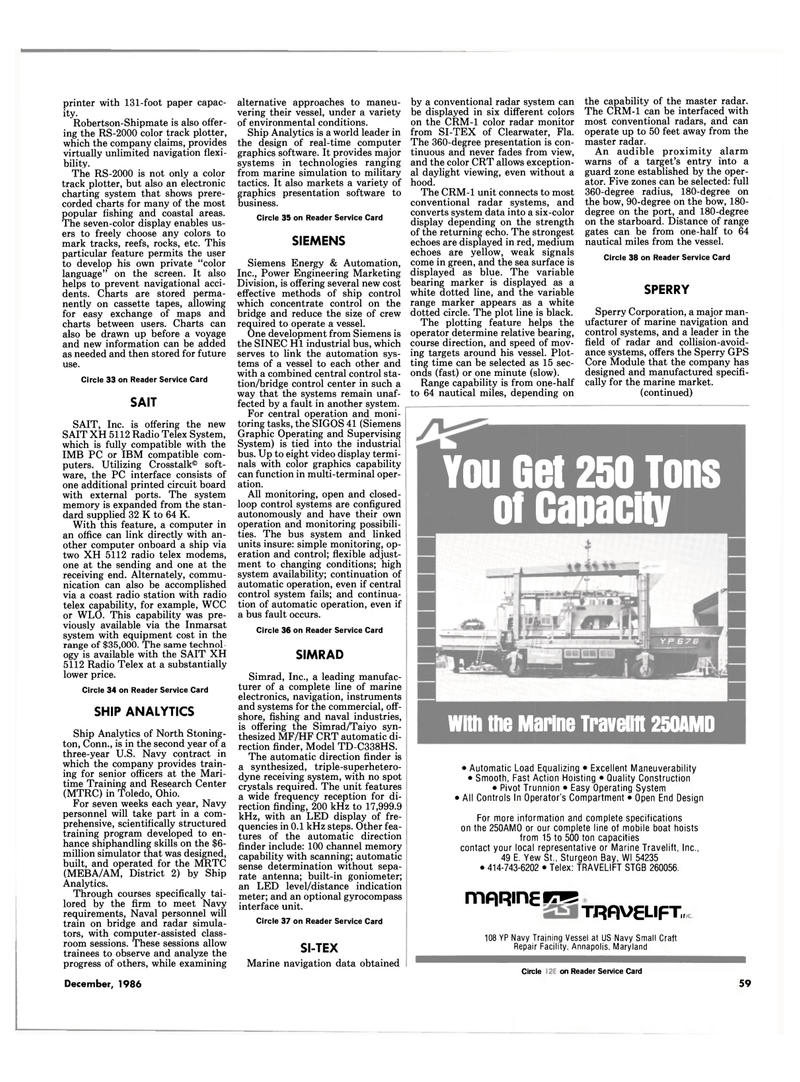
YOU Get 250 Tons of Capacity
I With the Marine Travelift 250A Ml ) • Automatic Load Equalizing • Excellent Maneuverability • Smooth, Fast Action Hoisting • Quality Construction • Pivot Trunnion • Easy Operating System • All Controls In Operator's Compartment • Open End Design
For more information and complete specifications on the 250AMO or our complete line of mobile boat hoists from 15 to 500 ton capacities contact your local representative or Marine Travelift, Inc., 49 E. Yew St., Sturgeon Bay, Wl 54235 • 414-743-6202 • Telex: TRAVELIFT STGB 260056. mRRinETO
TRflVgLIFT, 108 YP Navy Training Vessel at US Navy Small Craft
Repair Facility, Annapolis, Maryland
Circle 345 on Reader Service Card 59
