
Page 70: of Maritime Reporter Magazine (April 1998)
Read this page in Pdf, Flash or Html5 edition of April 1998 Maritime Reporter Magazine
 69
69
 71
71
ECDIS
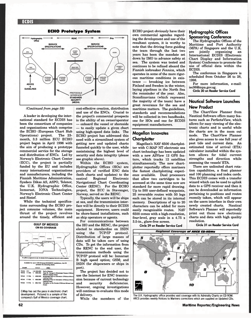
ECHO Prototype System (Continued from page 59)
A leader in developing the inter- national standard for ECDIS has been the consortium of companies and organizations which comprise the ECHO (European Chart Hub
Operations) project. The 23- month, 3.3 million ECU ECHO project began in April 1996 with the aim of producing a prototype commercial service for the storage and distribution of ENCs. Led by
Norway's Electronic Chart Center (ECC), the project is partially funded by the EU and includes many international organizations and manufacturers, including the
Finnish Maritime Administration,
Sysdeco Dikas AS, ASPO, Telenor, the U.K. Hydrographic Office,
Inmarsat, IONA Technologies,
Norway's Electronic Chart Center and Sintef.
While the technical specifica- tions surrounding the ECHO pro- ject consume volumes, the main thrust of the project revolves around the timely, efficient and
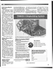
GULF OF MEXICO
CM-93 COVERAGE
For offshore navigational use only. Use detailed CM-93 navigational charts for inshore navigation.
Available for use in CM-93-based ECDIS/ECS installations, the CD contains the following charts:
CHART AREA
NOAA 411 1:2,160,000 Gulf of Mexico
NOAA 1115A 1: 456,394 Cape St. George to Mississippi Passes (Offshor
Mineral Leasing Areas)
NOAA 1116A 1: 458,596 Mississippi River to Galveston (Offshore Minera
Leasing Areas)
NOAA 1116A 1: 458,596 Mississippi River to Galveston (Offshore Minera
Leasing Areas)
NOAA 1117A 1: 460,732 Galveston to Rio Grande (Offshore Mineral Lea;
Areas)
C-Map has set the pace in electronic chart development. Pictured is a sample of the company's Gulf of Mexico coverage chart. cost-effective creation, distribution and use of the ENCs. Crucial to the project's commercial prospects is the ability of an owner/operator — onboard the vessel or shoreside — to easily update a given chart using high-speed data links. The
ECHO project has addressed this need with a streamlined system of getting new and updated charts funneled quickly to the user, while maintaining the highest level of security and data integrity (please see graphic above).
Within the ECHO system,
Hydrographic Offices (HOs) are providers of verified ENC data (both charts and updates) to the central Regional Electronic
Navigational Chart Coordinating
Center (RENC). For the ECHO project, the ECC in Stavanger,
Norway, served as the RENC.
Typically, the users will be ships at sea, and the transmission inter- face will be directly to their ECDIS equipment. However, users could be shore-based installations, such as ship operators or agents.
For communications between the HO and the RENC, the project elected to standardize on ISDN using the TCP/IP protocol.
Distribution of large masses of data will be taken care of using
CDs. To get the information from the RENC to the end user, the transmission methods using the
TCP/IP protocol will be: Inmarsat
B high speed option; GSM; and
ISDN (for shipowners or ships in port).
The project has decided not to use the Internet for ENC tranmis- sion because of current technology and security deficiencies.
However, ongoing investigations will continue to evaluate this mode of delivery.
While the members of the
ECHO project obviously have their own commercial agendas regard- ing the development and use of the resultant system, it is worthy to note that the driving force guiding the team through the last two years has been the mandate set down by IMO to advance safety at sea. The system was tested and continues to be refined aboard the
Finnish icebreaker Fennica, which operates in some of the more rigor- ous maritime conditions in exis- tence — breaking ice between
Finland and Sweden in the winter, laying pipelines in the North Sea the remainder of the year. Also,
Scandinavians (which represent the majority of the team) have a great reverance for the sea and maritime matters. The guidelines, standards and recommendations will be collected in two handbooks, one for HOs and one for ECDIS equipment manufacturers.
Magellan Innovates
Chartplotter
Magellan's NAV 6500 chartplot- ter with C-MAP NT electronic sea chart technology has been updated with a new AllView 12 GPS fea- ture, which tracks 12 satellites simultaneously. The new chart- plotter reportedly offers mariners the fastest chartplotting experi- ence available. Dual processors that allow two cartridges to be accessed at the same time now are standard for more rapid drawing.
Up to 500 user-defined waypoints, 25 reversible routes with 50 legs each can be stored in its internal memory. Descriptions of up to 20 characters can be added for more easily recognizable routes. NAV 6500 comes with a high-resolution, four-level, gray scale in a 4.75 x 3.5-in., glare-free screen.
Circle 29 on Reader Service Card
Hydrographic Offices
Sponsoring Conference
The Hydrographic Offices of the
Maritime and Port Authority (MPA) of Singapore and the U.K. are jointly organizing an
International ECDIS (Electronic
Chart Display and Information
System) Conference to promote the use of official data within the
ECDIS.
The conference in Singapore is scheduled from October 26 to 28, 1998.
For more information, e-mail: [email protected].
Circle 30 on Reader Service Card
Nautical Software Launches
New Product
The ChartView Planner from
Nautical Software offers many fea- tures such as PerfectaView, which allows for easy viewing of the elec- tronic charts and is useful while the charts are in the zoom out mode. The ChartView Planner also gives access to one full year of past tide and current data. An estimated time of arrival (ETA) calculator installed within the sys- tem allows for tidal current strengths and direction while assessing the vessels' ETA.
There are unlimited chart rota- tion capabilities, a float planner and 100 planning and index cards.
This ECDIS comes with a transfer wizard which can be used to uplink data to a GPS receiver and then it can be downloaded as information pertaining to positions and routes recently taken, which will appear on the users interface in their own newly created charts. Nautical
Software's Planner will reportedly print out these new electronic charts and data with high quality resolution.
Circle 31 on Reader Service Card
I
ADVICE &
GUIDELINES
STANDARDS
SECURITY (MEDIA)
Hydrographic RENC Ship
Office
SERVICE SERVICE
SPECIFICATIONS SPECIFICATIONS
The U.K. Hydrographic office provides vast coverage with its Admiralty Charts on CD ROM.
ARCS provides weekly Notices to Mariners corrections which are supplied on Updated CDs.
Of ARCS CO-ROMS 8
Si ««« 62 Maritime Reporter/Engineering News
