
Page 10: of Maritime Reporter Magazine (December 2014)
Great Ships of 2014
Read this page in Pdf, Flash or Html5 edition of December 2014 Maritime Reporter Magazine
 9
9
 11
11
10 Maritime Reporter & Engineering News • DECEMBER 2014
U.S. Navy
Aircraft Carrier
Leaves Drydock
With tugboats guiding it into the James
River, the aircraft carrier USS Abraham
Lincoln (CVN 72) was moved from one of
Newport News Shipbuilding’s drydocks to an outfi tting berth. With this move,
Newport News, a division of Huntington
Ingalls Industries (HII), offi cially complet- ed the drydock portion of the carrier’s mid-life refueling and complex overhaul (RCOH). Now at Outfi tting Berth 1, the carrier will undergo fi nal outfi tting and testing.
During the drydock phase of the RCOH,
Lincoln underwent extensive repair and construction work both inside and out to revamp the ship. Inside, Newport News shipbuilders re-preserved hundreds of tanks and replaced thousands of valves, pumps and piping components. On the outside, they painted the ship’s hull, up- dated the propeller shafts and installed refurbished propellers.
For these last 24 months before the car- rier’s redelivery, shipbuilders will fi nish up the overhaul and installation of the ship’s major components and test its systems. Shipbuilders must make sure that the electronics, combat and propul- sion systems are all operational before the carrier is re-delivered to the Navy in 2016. These fi nal months will also be dedicated to modernizing the ship’s liv- ing quarters and making them habitable for the sailors as they move aboard. The fi rst group of sailors began moving into the living spaces on Oct. 23.
Lincoln arrived at Newport News in
March 2013 for its RCOH and is on track to redeliver in 2016. RCOH is the mid- life refueling overhaul and maintenance availability of a Nimitz-class aircraft car- rier that produces a recapitalized carrier capable of supporting current and future warfare doctrine.
SHIPBUILDING
NEWS & ANALYSIS
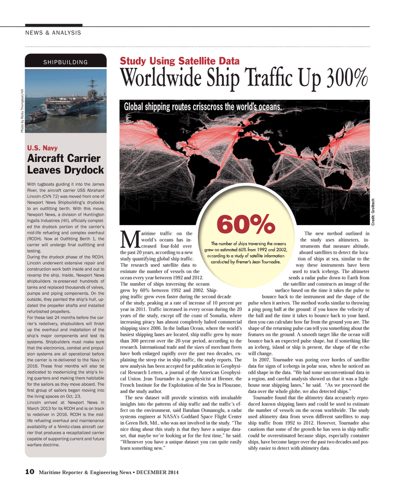
M aritime traffi c on the world’s oceans has in- creased four-fold over the past 20 years, according to a new study quantifying global ship traffi c.
The research used satellite data to estimate the number of vessels on the ocean every year between 1992 and 2012.
The number of ships traversing the oceans grew by 60% between 1992 and 2002. Ship- ping traffi c grew even faster during the second decade of the study, peaking at a rate of increase of 10 percent per year in 2011. Traffi c increased in every ocean during the 20 years of the study, except off the coast of Somalia, where increasing piracy has almost completely halted commercial shipping since 2006. In the Indian Ocean, where the world’s busiest shipping lanes are located, ship traffi c grew by more than 300 percent over the 20-year period, according to the research. International trade and the sizes of merchant fl eets have both enlarged rapidly over the past two decades, ex- plaining the steep rise in ship traffi c, the study reports. The new analysis has been accepted for publication in Geophysi- cal Research Letters, a journal of the American Geophysi- cal Union. Jean Tournadre is a geophysicist at Ifremer, the
French Institute for the Exploitation of the Sea in Plouzane, and the study author.
The new dataset will provide scientists with invaluable insights into the patterns of ship traffi c and the traffi c’s ef- fect on the environment, said Batuhan Osmanoglu, a radar systems engineer at NASA’s Goddard Space Flight Center in Green Belt, Md., who was not involved in the study. “The nice thing about this study is that they have a unique data- set, that maybe we’re looking at for the fi rst time,” he said. “Whenever you have a unique dataset you can quite easily learn something new.”
The new method outlined in the study uses altimeters, in- struments that measure altitude, aboard satellites to detect the loca- tion of ships at sea, similar to the way these instruments have been used to track icebergs. The altimeter sends a radar pulse down to Earth from the satellite and constructs an image of the surface based on the time it takes the pulse to bounce back to the instrument and the shape of the pulse when it arrives. The method works similar to throwing a ping pong ball at the ground: if you know the velocity of the ball and the time it takes to bounce back to your hand, then you can calculate how far from the ground you are. The shape of the returning pulse can tell you something about the features on the ground. A smooth target like the ocean will bounce back an expected pulse shape, but if something like an iceberg, island or ship is present, the shape of the echo will change.
In 2007, Tournadre was poring over hordes of satellite data for signs of icebergs in polar seas, when he noticed an odd shape in the data. “We had some unconventional data in a region, and careful analysis showed us that it was a light- house near shipping lanes,” he said. “As we processed the data over the whole globe, we also detected ships.”
Tournadre found that the altimetry data accurately repro- duced known shipping lanes and could be used to estimate the number of vessels on the ocean worldwide. The study used altimetry data from seven different satellites to map ship traffi c from 1992 to 2012. However, Tournadre also cautions that some of the growth he has seen in ship traffi c could be overestimated because ships, especially container ships, have become larger over the past two decades and pos- sibly easier to detect with altimetry data.
Study Using Satellite Data
Worldwide Ship Traffi c Up 300%
Cr edit: Gr olltech
Global shipping routes crisscross the world’s oceans.
Pho t o b y Ricky Thom pson/HII
MR #12 (10-17).indd 10 12/2/2014 11:57:05 AM
