Page 43: of Maritime Reporter Magazine (July 2017)
The Marine Communications Edition
Read this page in Pdf, Flash or Html5 edition of July 2017 Maritime Reporter Magazine
 42
42
 44
44
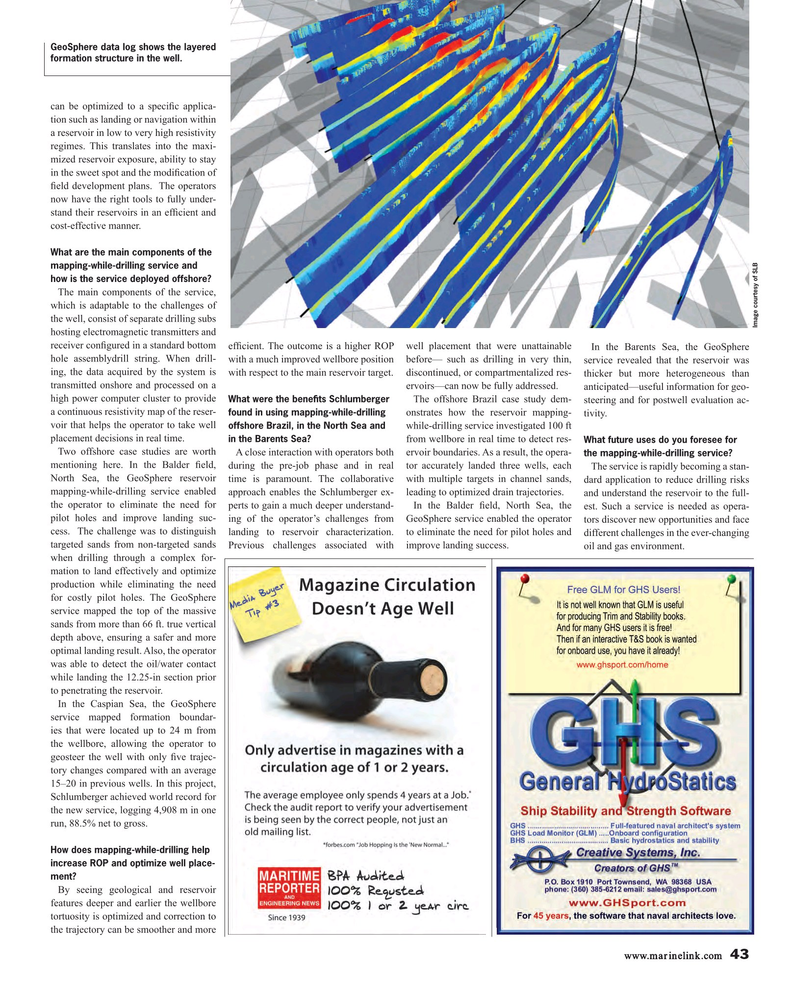
GeoSphere data log shows the layered formation structure in the well.
can be optimized to a speci? c applica- tion such as landing or navigation within a reservoir in low to very high resistivity regimes. This translates into the maxi- mized reservoir exposure, ability to stay in the sweet spot and the modi? cation of ? eld development plans. The operators now have the right tools to fully under- stand their reservoirs in an ef? cient and cost-effective manner.
What are the main components of the mapping-while-drilling service and how is the service deployed offshore?
The main components of the service, which is adaptable to the challenges of the well, consist of separate drilling subs
Image courtesy of SLB hosting electromagnetic transmitters and receiver con? gured in a standard bottom ef? cient. The outcome is a higher ROP well placement that were unattainable In the Barents Sea, the GeoSphere hole assemblydrill string. When drill- with a much improved wellbore position before— such as drilling in very thin, service revealed that the reservoir was ing, the data acquired by the system is with respect to the main reservoir target. discontinued, or compartmentalized res- thicker but more heterogeneous than transmitted onshore and processed on a ervoirs—can now be fully addressed. anticipated—useful information for geo- high power computer cluster to provide The offshore Brazil case study dem- steering and for postwell evaluation ac-
What were the bene? ts Schlumberger a continuous resistivity map of the reser- onstrates how the reservoir mapping- tivity.
found in using mapping-while-drilling voir that helps the operator to take well while-drilling service investigated 100 ft offshore Brazil, in the North Sea and placement decisions in real time. from wellbore in real time to detect res- in the Barents Sea? What future uses do you foresee for
Two offshore case studies are worth A close interaction with operators both ervoir boundaries. As a result, the opera- the mapping-while-drilling service?
mentioning here. In the Balder ? eld, during the pre-job phase and in real tor accurately landed three wells, each The service is rapidly becoming a stan-
North Sea, the GeoSphere reservoir time is paramount. The collaborative with multiple targets in channel sands, dard application to reduce drilling risks mapping-while-drilling service enabled approach enables the Schlumberger ex- leading to optimized drain trajectories. and understand the reservoir to the full- the operator to eliminate the need for perts to gain a much deeper understand- In the Balder ? eld, North Sea, the est. Such a service is needed as opera- pilot holes and improve landing suc- ing of the operator’s challenges from GeoSphere service enabled the operator tors discover new opportunities and face cess. The challenge was to distinguish landing to reservoir characterization. to eliminate the need for pilot holes and different challenges in the ever-changing targeted sands from non-targeted sands Previous challenges associated with improve landing success. oil and gas environment.
when drilling through a complex for- mation to land effectively and optimize production while eliminating the need for costly pilot holes. The GeoSphere service mapped the top of the massive sands from more than 66 ft. true vertical depth above, ensuring a safer and more optimal landing result. Also, the operator was able to detect the oil/water contact while landing the 12.25-in section prior to penetrating the reservoir.
In the Caspian Sea, the GeoSphere service mapped formation boundar- ies that were located up to 24 m from the wellbore, allowing the operator to geosteer the well with only ? ve trajec- tory changes compared with an average 15–20 in previous wells. In this project,
Schlumberger achieved world record for the new service, logging 4,908 m in one run, 88.5% net to gross.
How does mapping-while-drilling help increase ROP and optimize well place- ment?
By seeing geological and reservoir features deeper and earlier the wellbore tortuosity is optimized and correction to the trajectory can be smoother and more www.marinelink.com 43
MR #7 (42-49).indd 43 MR #7 (42-49).indd 43 7/7/2017 2:19:15 PM7/7/2017 2:19:15 PM
