
Page 36: of Maritime Reporter Magazine (December 2021)
Great Ships of 2021 Edition
Read this page in Pdf, Flash or Html5 edition of December 2021 Maritime Reporter Magazine
 35
35
 37
37
TECH FEATURE NAVIGATION RADAR
GINA helps guide
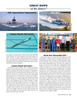
Sikuliaq through the ice he research vessel Sikuliaq, a Center notes that satellites have only Oceanic and Atmospheric Administra- 261-ft. ice-capable research ves- been continuously monitoring sea ice tion’s Joint Polar Satellite System.
sel operated by UAF, navigated since 1979. Prior to that, captains had Acquiring imagery through the GINA
Tamong and around the chunks to rely on their crews’ ? rsthand observa- system in Fairbanks enhances the use- and slabs of Arctic sea ice above Alaska tions and on weekly ice charts based on fulness of Roberts’ map server. Although for several weeks on two voyages this airborne observations and reports from the map server relies heavily on cloud- fall, breaking through frozen slabs when observers on the coasts and other ships. penetrating SAR imagery that shows it had to. Satellite imagery produced at Avoiding the ice is often best for the the ice in great detail, SAR satellites im- the Geographic Information Network of scientists, who usually have a limited age the same area just once every day
Alaska, or GINA, at the University of amount of time to get what they need or less often. Such infrequency means
Alaska Fairbanks Geophysical Institute from the open water. That was the situ- data from a dynamic Arctic Ocean can helped the ship weave its way through ation on a seven-week research voy- be quickly outdated. the ice. age UAF geophysics professor Bernard Images via GINA can capture the
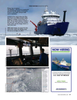
The satellite images, along with satel- Coakley took into the Chukchi and same area more frequently because the lite data from other sources, show up on Beaufort Seas and with a Navy-funded images cover a wider area than those the Sikuliaq’s bridge in an easy-to-use voyage in some of the same waters. of a SAR satellite. But the surface in a web-based map server. The map server Satellite information retrieved from GINA image sometimes might be ob- has been on the Sikuliaq since 2013, GINA and displayed in Roberts’ tool, scured by clouds.
when the ship was built. along with other information sources, There’s also the bene? t of GINA be-
Steve Roberts, the Sikuliaq’s science also helps improve the safety, effective- ing located in Fairbanks.
systems engineer, got the idea for the ness and ef? ciency of the Sikuliaq’s “We have antennas located in places map server while working aboard the voyages. The National Science Foun- like Interior Alaska and the technology
USCGC Healy, the Coast Guard’s ice- dation owns the Sikuliaq, a part of the to deliver these products right after the breaker, and has re? ned his system over U.S. academic research ? eet, and the satellites ? y overhead,” said Jennifer the years. UAF College of Fisheries and Ocean Delamere, director of the Geographic “I remember every day scientists on Sciences operates the ship. Information Network of Alaska. “In pre- the Healy saying, “Where are we?’,” he “There’s tight interaction between the vious years it would have taken hours or said from aboard the Sikuliaq as it sailed navigator and the scientists,” Roberts days to get the information.” in ice-strewn waters about 350 miles said. “Scientists can determine where “This is just a great example of UAF north of Alaska. “There was nothing on the ship goes, but a lot of times it’s the research helping the Sikuliaq get around the ship that provided information rela- ice that decides.” in the ice. And it’s taking advantage of tive to the science missions. We need to “Scientists need to maintain situation- local technology, both what Steve de- know where we are relative to science al awareness of the conditions,” he said. veloped and GINA data, on the bridge stations and moorings. “When you are “And that’s the purpose of this tool: to of the ship,” she said.
working in ice, the ice controls where allow us to maintain situational aware- Delamere added that the Geographic you are,” he said. “Knowing where sea ness for scientists and for driving the Information Network of Alaska pro- ice is at all times is critical.” ship.” vides support for many operations in ad-
Navigating sea ice is a burgeoning Satellite imagery is acquired by two dition to those of the Sikuliaq. ? eld of interest as shipping increases in fundamental types of sensors: passive GINA data is also used by the Alaska the Arctic, which is becoming increas- and active. Sea Ice Program to analyze sea ice ex- ingly open though not entirely ice-free. Data from each type of sensor can tent and characteristics, by ? re? ghting
Icebergs from coastal sources still bob be processed into different products for agencies to show wild? re activity and along, and thick slabs of sea ice still different uses. GINA uses data from by other agencies to show volcanic ash, drift. The National Snow and Ice Data passive-sensor satellites in the National river ice and ? ooding, and precipitation.
36 Maritime Reporter & Engineering News • December 2021
MR #12 (34-43).indd 36 12/3/2021 1:25:13 PM
