
Page 65: of Offshore Engineer Magazine (Mar/Apr 2014)
Read this page in Pdf, Flash or Html5 edition of Mar/Apr 2014 Offshore Engineer Magazine
 64
64
 66
66
of the basic geochemical parameters.
Russia
Biologists take net samples to determine the amount and species of organisms that are found in the water column, as well as sediment cores of the sea? oor with a heavy multicoring device. The full procedure takes several hours to complete.
Besides the usual station work carried out during the expedition, the project takes measurements from year-round oceanographic moorings (sea? oor obser- vatories). The procedure is to anchor oceanographic instruments on the sea? oor and in the water column, which record parameters such as temperature, salinity or ocean currents in half-hourly intervals until the following year, when instruments are recovered and data are downloaded for analysis. Mooring work The Russian research vessel . Viktor Buynitskiy
Photo courtesy of the captain of the icebreaker 50 Years of Victory.
in dif? cult environments such as the seasonally ice-covered Laptev Sea is predict the fate of the Transpolar Drift out August-September 2013 aboard the characterized by differences in tempera- quite risky and loss of instrumentation (TPD) System under a changing climate. ~50m-long Russian-? agged vessel Viktor ture and salinity, but also carry their own is not unusual, but previous success-
Scientists from different Russian and
Buynitskiy. The science party boarded chemical signatures in nutrients and ful deployments in combination with
German Research Institutes participate to the ship in Arkhangelsk and sailed isotopes, and have a strong impact on the shipboard expeditions lead to signi? cant along the Northern Sea Route across the organisms that inhabit the water column advancements in the understanding of investigate sea ice and ocean circulation, biological and chemical properties of the
Barents and Kara Seas into the Laptev and dwell on the sea ? oor. how the ocean interacts with sea ice and
One aim of the expedition was to map
Sea. As was often the case in the recent the atmosphere.
water column and the sea ? oor as well as the major physical and biogeochemical aim to improve the understanding of the years, the passage was largely ice-free, The reduction in Arctic Sea ice opens parameters, which can then be compared except a small region in Vilkitsky Strait, a up new opportunities for shipping region’s geological past. Additionally, the with conditions found during previous central Arctic as well as the Fram Strait narrowing passage between the Kara and along the Northern Sea Route and other expeditions in order to determine the vari-
Laptev Seas. The expedition was guided offshore activities, but can certainly region are investigated as well for a com- ability in the region. The sampling strategy prehensive picture of the TPD.
into the study region through the Strait complicate the research from mid-sized is such that the vessel occupies selected in a convoy of four vessels, lead by the vessels. Storms that periodically move
Laptev Sea expedition Transdrift 21 stations throughout the region. Each sta-
Russian nuclear icebreaker Yamal. over the region generate large waves and
During more than 20 years of Russian- The Laptev Sea shelf features extreme swell, as the ice edge is far to the north, tion then follows a clear plan of action:
German Laptev Sea research, a total of 21 fronts and gradients between the differ- and may interrupt the sampling or at the
First, temperature and salinity of the water (Transdrift) expeditions were carried out, ent water masses that are characterized least make life on board less comfortable.
column are measured with a CTD (conduc- most of them shipboard summer expedi- by the Lena River out? ow and the warm A novelty applied during the tivity-temperature-depth) device, attached tions, but also some helicopter-based and saline water masses that are found Transdrift 21 expedition was the use of to a water sampling rosette, which allows winter expeditions. The most recent offshore along the continental slope. an UnderwayCTD system, which allowed researchers to take water samples from expedition, Transdrift 21, was carried The different water masses are not only to pro? le temperature and salinity of selected depths for subsequent analysis the water column in rougher seas and while the ship is en route. The underway
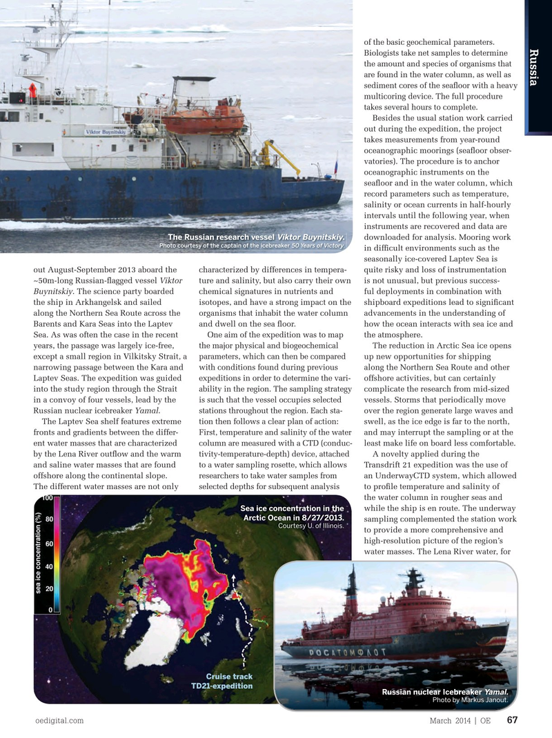
Sea ice concentration in the
Arctic Ocean in 8/27/2013. sampling complemented the station work
Courtesy U. of Illinois.
to provide a more comprehensive and high-resolution picture of the region’s water masses. The Lena River water, for
Cruise track
TD21-expedition
Russian nuclear Icebreaker
Yamal.
Photo by Markus Janout.
Laptev Sea surface temperature (°C) during Transdrift 21 in early September 2013.
oedigital.com March 2014 | OE 67 066_OE0314_Geofocus4_LaptevSea.indd 67 2/21/14 1:25 PM