
Page 22: of Marine News Magazine (April 2024)
Read this page in Pdf, Flash or Html5 edition of April 2024 Marine News Magazine
 21
21
 23
23
Feature
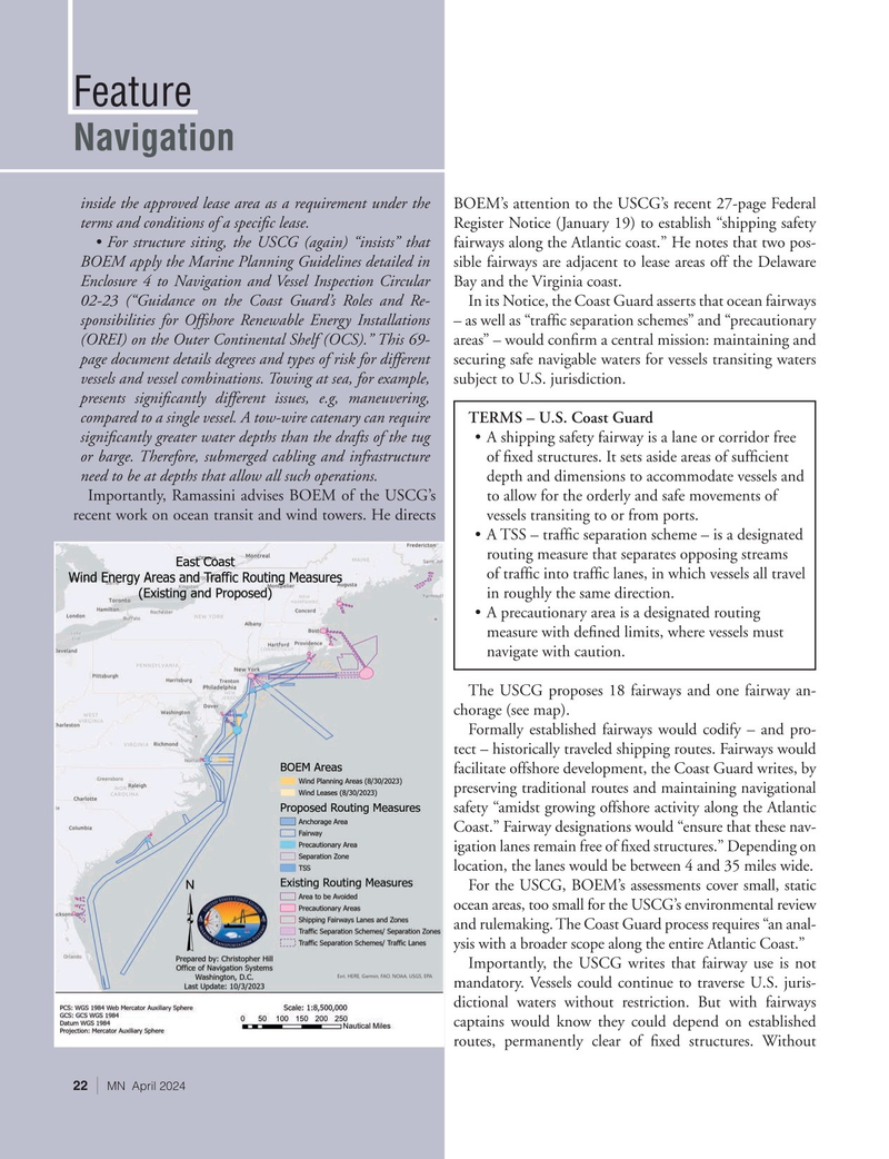
Navigation inside the approved lease area as a requirement under the BOEM’s attention to the USCG’s recent 27-page Federal terms and conditions of a speci? c lease. Register Notice (January 19) to establish “shipping safety • For structure siting, the USCG (again) “insists” that fairways along the Atlantic coast.” He notes that two pos-
BOEM apply the Marine Planning Guidelines detailed in sible fairways are adjacent to lease areas off the Delaware
Enclosure 4 to Navigation and Vessel Inspection Circular Bay and the Virginia coast.
02-23 (“Guidance on the Coast Guard’s Roles and Re- In its Notice, the Coast Guard asserts that ocean fairways sponsibilities for Offshore Renewable Energy Installations – as well as “traf? c separation schemes” and “precautionary (OREI) on the Outer Continental Shelf (OCS).” This 69- areas” – would con? rm a central mission: maintaining and page document details degrees and types of risk for different securing safe navigable waters for vessels transiting waters vessels and vessel combinations. Towing at sea, for example, subject to U.S. jurisdiction.
presents signi? cantly different issues, e.g, maneuvering, compared to a single vessel. A tow-wire catenary can require TERMS – U.S. Coast Guard signi? cantly greater water depths than the drafts of the tug • A shipping safety fairway is a lane or corridor free or barge. Therefore, submerged cabling and infrastructure of ? xed structures. It sets aside areas of suf? cient need to be at depths that allow all such operations. depth and dimensions to accommodate vessels and
Importantly, Ramassini advises BOEM of the USCG’s to allow for the orderly and safe movements of recent work on ocean transit and wind towers. He directs vessels transiting to or from ports.
• A TSS – traf? c separation scheme – is a designated routing measure that separates opposing streams of traf? c into traf? c lanes, in which vessels all travel in roughly the same direction.
• A precautionary area is a designated routing measure with de? ned limits, where vessels must navigate with caution.
The USCG proposes 18 fairways and one fairway an- chorage (see map).
Formally established fairways would codify – and pro- tect – historically traveled shipping routes. Fairways would facilitate offshore development, the Coast Guard writes, by preserving traditional routes and maintaining navigational safety “amidst growing offshore activity along the Atlantic
Coast.” Fairway designations would “ensure that these nav- igation lanes remain free of ? xed structures.” Depending on location, the lanes would be between 4 and 35 miles wide.
For the USCG, BOEM’s assessments cover small, static ocean areas, too small for the USCG’s environmental review and rulemaking. The Coast Guard process requires “an anal- ysis with a broader scope along the entire Atlantic Coast.”
Importantly, the USCG writes that fairway use is not mandatory. Vessels could continue to traverse U.S. juris- dictional waters without restriction. But with fairways captains would know they could depend on established routes, permanently clear of ? xed structures. Without 22 | MN April 2024