Page 42: of Marine Technology Magazine (April 2005)
Read this page in Pdf, Flash or Html5 edition of April 2005 Marine Technology Magazine
 41
41
 43
43
Survey Approach/Process
Surveys were conducted using AUV's that collect a depth measurement each second during a pre-planned mission. Throughout the mission, vehicles traverse the pond areas recording geospatial data linking position with depth. These robust data sets were then translated into bathymetric surfaces for the five ponds.
There are a number of features that make this technolo- gy ideal for this application including: Lithium Ion power source (allowing the AUV to operate for greater than ten hours per recharge), 2-knot surface speed (providing quick data collection), 1-second data logging (provides robust data sampling), and GPS reference accuracy (enables pin-point accuracy of sample location). For fur- ther details regarding the Iver2 features, please refer to the
AUV description outlined below.
ATMC selected ArcGIS for data processing; this soft- ware package is already in use by the city of New Bedford is ideal for interpreting data collected from the Iver2.
ArcGIS provides spatial analysis tools to examine the depth levels of the pond for water volume calculations.
ArcGIS features tools that offer many options for spatial modeling and visual analysis. Since the City of New
Bedford already possess the platform, information collect- ed during this project can be electronically cataloged and accessed when needed. Should update or spot surveys be completed in the future, analysis of changes can easily be compared, likewise other information on water quality and environmental factors can be layered on this base bathymetry information providing a more complete char- acterization of the water body.
AUV Description
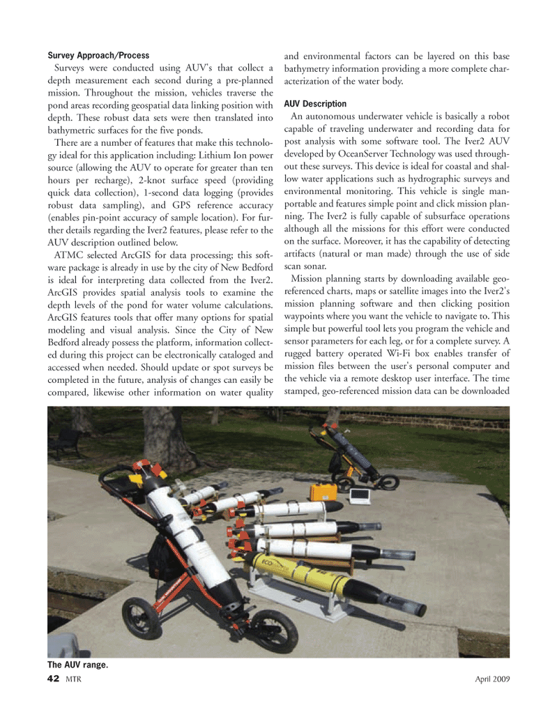
An autonomous underwater vehicle is basically a robot capable of traveling underwater and recording data for post analysis with some software tool. The Iver2 AUV developed by OceanServer Technology was used through- out these surveys. This device is ideal for coastal and shal- low water applications such as hydrographic surveys and environmental monitoring. This vehicle is single man- portable and features simple point and click mission plan- ning. The Iver2 is fully capable of subsurface operations although all the missions for this effort were conducted on the surface. Moreover, it has the capability of detecting artifacts (natural or man made) through the use of side scan sonar.
Mission planning starts by downloading available geo- referenced charts, maps or satellite images into the Iver2's mission planning software and then clicking position waypoints where you want the vehicle to navigate to. This simple but powerful tool lets you program the vehicle and sensor parameters for each leg, or for a complete survey. A rugged battery operated Wi-Fi box enables transfer of mission files between the user's personal computer and the vehicle via a remote desktop user interface. The time stamped, geo-referenced mission data can be downloaded 42 MTR April 2009
The AUV range.
MTR#3 (34-49).qxd 3/27/2009 2:33 PM Page 42