The Autonomous Future of Seabed Mapping
By Kira Coley
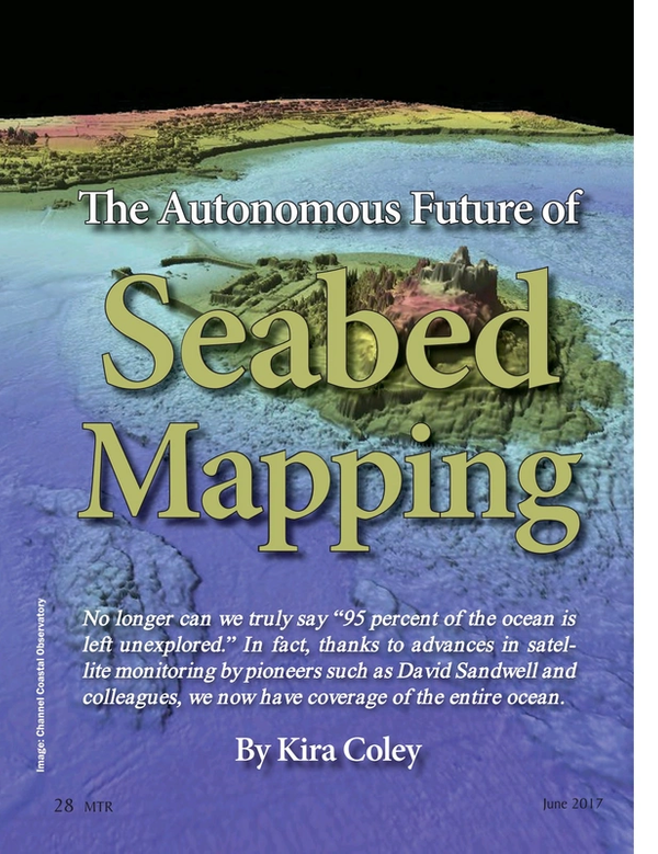
No longer can we truly say “95 percent of the ocean is left unexplored.” In fact, thanks to advances in satellite monitoring by pioneers such as David Sandwell and colleagues, we now have coverage of the entire ocean.
While these maps are only at a resolution of around 5 kilometers – less than current global maps of Mars and Venus – it has given us submarine topography data in locations we weren’t able to access previously. For us to really understand what lies under the surface, scientists must travel to the site and use acoustic techniques such as sonar and multibeam bathymetry to produce detailed maps. But, the financial and logistical obstacles to achieving this across the entire ocean have meant only around 0.5 percent of the seafloor has been mapped to the highest resolution achievable today. Now, the launch of 4D Ocean could mean the end of these barriers and the start of an autonomous, low-cost future in seabed mapping. Autonomous platforms will allow more people to access the technology and together, the opportunity to map Earth’s largest ecosystem in more detail than ever before.
Over the last 15 years, the transition from the single beam to multibeam echosounders has been instrumental in the broader use of bathymetry. And, along with its associated products, backscatter and water column data, this technology has helped to drive the Blue Economy. The rapid pace of developments in this field has not only been pushed by advancements in mapping techniques but also the surge in seabed mapping projects in areas such as oil and gas exploitation, dredging, maritime construction and marine conservation.
Traditionally, small survey vessels less than 16 meters long have been used to collect multibeam data in the inshore and coastal waters, with the larger vessels operating further out. Sometimes a multi-vessel approach is used whereby a field office is a setup for the inshore vessel while the offshore vessel works 24/7. The efficiency of shallow water surveys is reduced because the swath width becomes smaller in size and, because of potential hazards, surveys are nearly always daylight operations. The inshore vessels also have to transit from the local port, sometimes adding hours each way for remote locations.
The innovative U.K. based company NetSurvey Limited helped push the boundaries of multibeam technology from its infancy to the defacto tool for seabed mapping that it is today. In 2011, the company merged with MMT Group. Now this year, NetSurvey’s founder Duncan Mallace has launched 4D Ocean, an industry first company he hopes will pave the way for a next big thing in seabed mapping techniques. 4D Ocean aims to make autonomous survey the new norm for conducting seabed surveys and will provide services for hydrographic survey, coastal engineering, habitat mapping, as well as pipeline and cable surveys.
Mallace said, “I get really excited about new technology for seabed mapping. What I love most about it is taking something new and making something exceptional from it. We are unique. We don’t own vessels or have a marine crew, yet operate a full hydrographic survey capability.
“The systems we use are entirely autonomous, not remote controlled, and that includes the data collection capability too, not just the guidance.
“We are passionate about all aspects of seabed mapping and about using the very best technology.”
Autonomy in Seabed Mapping
4D Ocean believes that autonomous solutions are far more efficient than traditional methods of mapping. Autonomous surface vehicles (ASVs), unmanned aerial vehicles (UAVs) and autonomous underwater vehicles (AUVs) can be deployed from almost anywhere, with state-of-the-art guidance systems which make for better survey progress, and fewer infill lines. ASVs are not constrained by harbors, so transit times are much reduced, and all systems are battery powered, using clean and green energy.
Autonomous systems do not require ports and can also access areas which are either too hazardous or too difficult to get to, making for better coverage and safer operations. The technology is also quiet – so not only is the environment protected but the data quality is far better. As well as improvements in safety and data quality, the data can also be processed immediately, thereby spotting issues early in the project and raising the efficiency of the survey process.
“We use UAVs to map the drying areas and also to identify potential hazards for the ASV. In the future, we will also be able to use the technology in larger surveys where an offshore vessel mothership launches ASVs to survey specific areas. I believe that the swarm approach, adopted by some at the moment, isn’t the one that will ultimately be used, but we are not quite there yet for giving ASVs specific areas. It won’t be far off though,” Mallace said.
4D Ocean will work closely with its ASV supplier SeaRobotics, multibeam sonar supplier R2Sonic, AUV and sonar supplier Kongsberg and its software providers QPS and Hypack to push the technology forward for the benefit of the seabed mapping community. The company is using the SeaRobotics USV 2.5, which is equipped with an R2Sonic 2020 multibeam sonar, Applanix Wavemaster inertial system and an autonomous SVP winch.
For coastal zones, the 4D Ocean has chosen the senseFly eBee Plus RTK. Mallace has chosen the best mapping drones in the industry which can survey for almost an hour to cover 12 square kilometers. This allows the operators to see where not to go with the ASV and also capture high-resolution imagery and topography of the land areas.
Mallace explained, “Very technical pieces of oceanographic or hydrographic equipment take a while to be adopted. First, the technology needs to develop a track record and prove that they fulfill the promise they have and show, economically, that it makes sense to adopt them. The technology has literally just arrived for full autonomous capability but it is the first stage, and I’m sure that there will be many improvements and features required. Collision avoidance and regulations need to be implemented before anyone can even think of not requiring a vessel further offshore or out of sight.”
“At the early stages, companies and organizations are willing to subcontract a new technology as it de-risks them. Therefore, there is now a need for an autonomous specialist company that can provide the technology to the industry. We can combine bathymetry data collected by the ASVs with topographic data and photography compiled by the UAVs to produce stunningly accurate and complete data sets.”
An Autonomous Mapping Future
Recent advancements in technology have opened the autonomous survey capability to the industry. While the technology will continue to evolve, and improve over the coming years, there will still be some challenges to overcome before 4D Ocean’s new approach can be fully adopted. Mallace said, “Local regulations may slow or stop the adoption of autonomous systems at different times around the world. For instance, the FAA in the U.S., only as recently as last year, allowed commercial UAV operations. In the Middle East being able to easily use the extended Wi-Fi on the ASVs is not yet possible. So, the biggest challenges are going to be governments and their adoption of autonomous technology. We are lucky in the U.K. that the chair of the autonomous committee is also the Deputy Director of the Navigation and Safety Branch of the MCA and is forward thinking, so I think here things will progress smoothly.”
“I’m taking this year very much as a learning exercise to find the limits of the technology and to start to introduce the autonomous systems as a natural choice. Initially, the ASV usage will be in coastal, lake and river surveys, complemented by the UAVs to ensure a seamless Sea and Land final product. The MUNIN AUV will be tasked with pipeline and cable inspection surveys. It is more about using the same survey methods but with a new platform - like getting used to using an electric car instead of a petrol one.”
Over the next year, 4D Ocean will test the performance of the ASV in different sea states, currents and surface winds, and have plans to map two coastal strips of England, some unchartered waters in Scotland and kelp habitats in South Africa. Mallace also intends to see if he can extract bathymetry from multi-spectral cameras mounted on the UAV in a similar way to satellite-derived bathymetry - a method which, if achievable, promises far greater resolution than satellites current capabilities.
“In five years’ time, I think the coastal and inshore market will be mostly surveyed by ASVs, with larger ASVs for specific tasks offshore. In 10 years’ time, we may well have serious offshore capable autonomous survey vessels for all seabed mapping tasks. The time it takes for technology to move from infancy to ubiquitous adoption is becoming smaller and smaller. I believe it won’t be long until we have an autonomous future in seabed mapping, offering low-cost, economically viable solutions. This could mean even more people can access the technology and get closer to the ultimate goal - detailed maps on the world’s oceans.”
Acknowledgements
Duncan Mallace, Founder of 4D Ocean.
(As published in the June 2017 edition of Marine Technology Reporter)
Read The Autonomous Future of Seabed Mapping in Pdf, Flash or Html5 edition of June 2017 Marine Technology