Page 41: of Marine Technology Magazine (November 2019)
MTR White Papers: Subsea Vehicles
Read this page in Pdf, Flash or Html5 edition of November 2019 Marine Technology Magazine
 40
40
 42
42
oat-mounted sonar has long these technologies are changing the humans all rely on the Kootenai River, it been the technology of choice ways rivers and inland waterways are has become a hotbed of research on ? u- for gathering bathymetry data modeled, and delivering valuable new vial processes, species protection, habi-
Bfor inland waterways, but it insights into water resource manage- tat enhancement, restoration and ? ood isn’t ideal for riverine environments. As ment and aquatic habitats. dynamics for a collection of scientists, a result, the GIS community has faced environmental groups, tribes and local signi? cant hurdles when they try to Exploring the Kootenai River communities.
model submerged terrain with the same The Kootenai River ? ows from its In 2017, as part of the Inland Bathym- accuracy and resolution that they can headwaters through a rugged region etry Research Project (IBRP), the U.S. achieve in deeper water or using remote of southwestern Canada, Montana and Geological Survey (USGS) contracted sensing for terrestrial landscapes. Idaho, before meeting the Columbia Quantum Spatial Inc. (QSI) to do a col-
Advancements in remote sensing – River 500 miles later. The watershed laborative study examining applications including use of topo-bathymetric lidar drains a 19,000-square-mile area, span- of remote sensing for more effective combined with hyperspectral imaging ning six different biomes that provide analysis of shallow water ? oodplains – are showing great potential in address- drinking water and agricultural irriga- and riverine environments. With re- ing these historical challenges. And, tion, and support a rich variety of ? ora search and restoration activities under- in the process, the ? rst applications of and fauna. Given that ? sh, wildlife and way along the Kootenai River, USGS identi? ed this area as a perfect pilot site for evaluation of topo-bathymetric lidar to characterize ? uvial patterns and pro- cesses, identify optimal conditions, and standardize collection and processing techniques.
Creating a New Remote
Sensing Platform
QSI was tasked to collect and process lidar for bathymetric data, co-acquired natural color imagery for ancillary in- formation, and hyperspectral imagery for depth and ? ow modeling across a 54-mile stretch of the Kootenai River in Northern Idaho. With this pilot pro- gram, the USGS hoped to gain better insights into the river and evaluate the potential large-scale commercial value of new techniques for mapping inland bathymetry.
They hoped to increase ef? ciency and signi? cantly reduce cost by combining all three remote sensing technologies into one aircraft for a single deploy- ment. But doing so created challenges
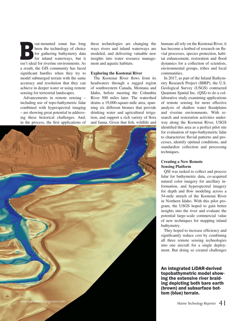
An integrated LiDAR-derived topobathymetric model show- ing the extensive river braid- ing depicting both bare earth (brown) and subsurface bot- tom (blue) terrain.
www.marinetechnologynews.com
Marine Technology Reporter 41
MTR #9 (34-49).indd 41 12/2/2019 11:25:42 AM