
Page 41: of Marine Technology Magazine (June 2020)
Read this page in Pdf, Flash or Html5 edition of June 2020 Marine Technology Magazine
 40
40
 42
42
ing new meshes, Fledermaus supported each follow up release. To maximize the surface of a dense point cloud. A key the importing of meshes created using benefts of adding a new data structure part of the mesh construction is deter-
Structure From Motion (SfM) tech- to your workfow, the creation process mining the orientation, or shape from niques in 3rd party software, such as needs to be accessible, and well integrat- the point cloud. By using a data source
Agisoft Metashape and Pix4D. Users ed. To achieve these goals, the Fleder- with recorded navigation and orientation desired improvements for better han- maus mesh creation tools were designed data, Fledermaus can make an improved dling of large meshes, and wanted the to be almost as simple as creating a stan- mesh compared to generic mesh creation same functionality they were used to dard gridded surface. algorithms. when working with gridded surface. In addition to opening up the mesh cre-
This included operations such as apply- ation process to both multibeam and Li- Applications of a 3D Mesh ing color maps, measurement tools, and DAR data, this also allows SfM derived In terms of applications, this technol- interactive profling. point clouds to be improved before mesh ogy is benefcial anywhere that accurate
Initial applications for these tools creation. There are often times when SfM shape reconstruction is of utmost impor- were coastal and near shore mapping data requires further processing, because tance. This can apply when proper iden- and analysis, with data acquired from of defciencies in the original pre-built tifcation and measurement of features aerial drones. Figure 1 illustrates an ex- mesh. By using the point editing and is critical to risk management, and to a ample of an inter-tidal area represented QC tools in Qimera software, the point greater extent in situations where there as a mesh in Fledermaus. With rapid cloud data can be improved, and a more will be close interaction with the sur- advancements in lighting and camera accurate mesh created in Fledermaus. veyed objects. When performing marine technology, SfM tools were also applied There are also specialized tools, such as salvage, construction, or asset inspec- underwater, with impressive high densi- the SfM add-on for Qimera, which can tion, it is critical to have the most com- ty point cloud produced from ROV and be used to correct for refraction errors in prehensible and accurate representation
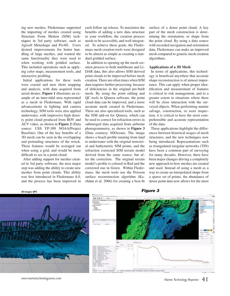
AUV video, as shown in Figure 2 (Data submerged data acquired from airborne of the data. source: USS YP-389 NOAA/Project photogrammetry, as shown in Figure 3 These applications highlight the differ-
Baseline). One of the key benefts of a (Data courtesy 4DOcean). The image ences between historical usages of mesh 3D mesh can be seen in the overlapping shows a beach profle running from land structures, and the new techniques now and protruding structures of the wreck. to underwater with the original terrestri- being introduced. Representations such
These features would be averaged out al and bathymetric SfM points, and the as triangulated irregular networks (TIN) when using a grid, and would be more refraction corrected SfM terrain model have been a common part of surveying diffcult to see in a point cloud. derived from the same source, but af- for many decades. However, there have
After adding support for meshes creat- ter the correction. The original terrain been major changes driving a completely ed in 3rd party software, the next major model’s profle is colored in Red and the new approach to how meshes are created step was adding the ability to create new corrected one in Green. Within Fleder- and used. Instead of using a mesh as a meshes from point clouds. This ability maus, the mesh tools use the Poisson way to create an interpolated shape from was frst introduced in Fledermaus 8.0, surface reconstruction algorithm (Ka- a sparse set of points, the abundance of and the process has been improved in zhdan et al. 2006) for creating a best-ft dense point data now allows for the most
Figure 3
All images QPS www.marinetechnologynews.com
Marine Technology Reporter 41