
Page 21: of Marine Technology Magazine (November 2021)
Ocean Observation: Gliders, Buoys & Sub-Surface Networks
Read this page in Pdf, Flash or Html5 edition of November 2021 Marine Technology Magazine
 20
20
 22
22
be obscured by clouds.
How it works
There’s also the bene? t of GINA being located in Fairbanks.
Satellite imagery is acquired by two fundamental types of “We have antennas located in places like Interior Alaska and sensors: passive and active.
Passive sensors monitor radiation in speci? c wavelengths the technology to deliver these products right after the satellites continually emitted from the Earth, either at the surface or ? y overhead,” said Jennifer Delamere, director of the Geo- graphic Information Network of Alaska. “In previous years it from the atmosphere.
Active sensors such as synthetic aperture radar emit signals would have taken hours or days to get the information.” “This is just a great example of UAF research helping the that travel through clouds, bounce off the Earth’s surface and
Sikuliaq get around in the ice. And it’s taking advantage of return to the sensor. local technology, both what Steve developed and GINA data,
Data from each type of sensor can be processed into different on the bridge of the ship,” she said.
products for different uses.
Delamere added that the Geographic Information Network
GINA uses data from passive-sensor satellites in the Na- tional Oceanic and Atmospheric Administration’s Joint Polar of Alaska provides support for many operations in addition to those of the Sikuliaq.
Satellite System.
GINA data is also used by the Alaska Sea Ice Program to an-
Acquiring imagery through the GINA system in Fairbanks enhances the usefulness of Roberts’ map server. Although alyze sea ice extent and characteristics, by ? re? ghting agen- cies to show wild? re activity and by other agencies to show the map server relies heavily on cloud-penetrating SAR im- volcanic ash, river ice and ? ooding, and precipitation.
agery that shows the ice in great detail, SAR satellites im- “GINA is ready to help whoever and whenever — whether age the same area just once every day or less often. Such infrequency means data from a dynamic Arctic Ocean can it’s for something on land, in the atmosphere, or way out at sea,” Delamere said.
be quickly outdated.
Images via GINA can capture the same area more frequently
Excerpted with permission from the University of Alaska because the images cover a wider area than those of a SAR satellite. But the surface in a GINA image sometimes might Fairbanks Geophysical Institute.
- Simple to operate
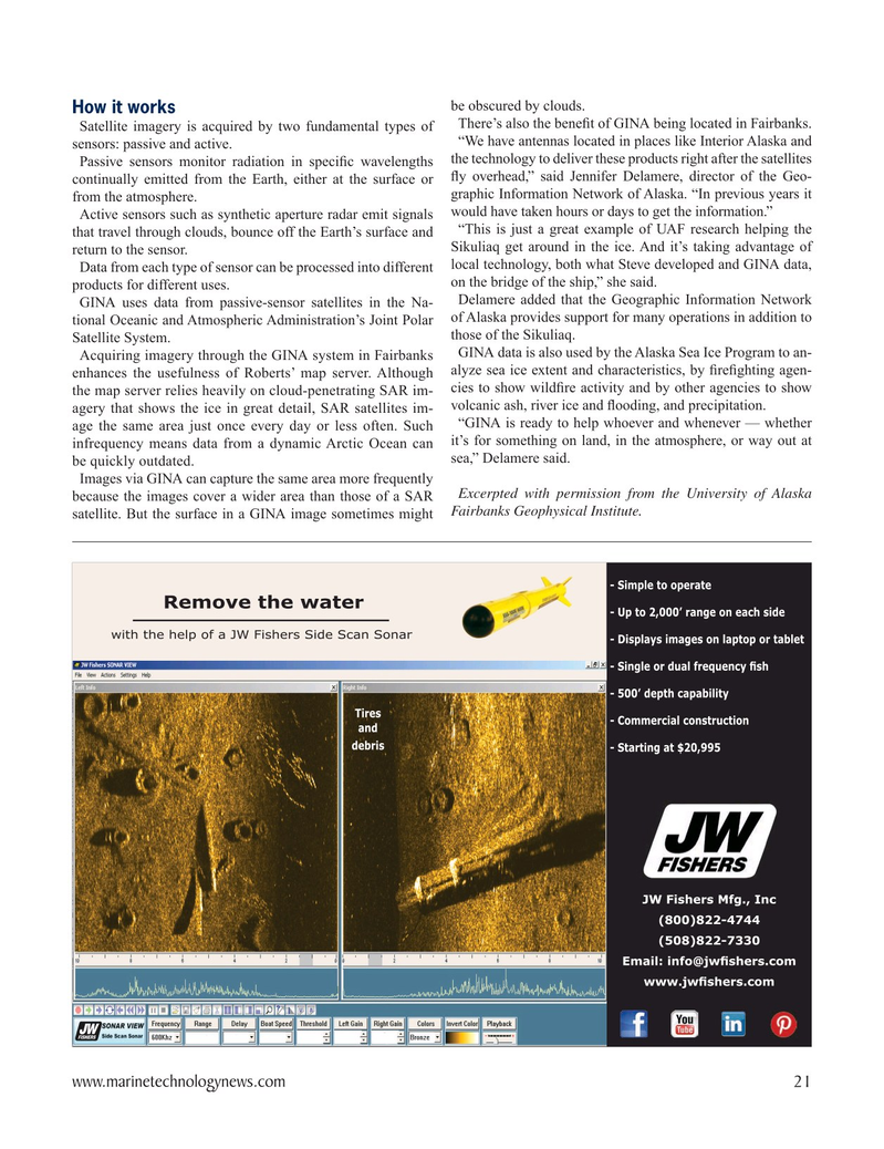
Remove the water - Up to 2,000’ range on each side with the help of a JW Fishers Side Scan Sonar - Displays images on laptop or tablet 6LQJOHRUGXDOIUHTXHQF\¿VK - 500’ depth capability
Tires - Commercial construction and debris - Starting at $20,995
JW Fishers Mfg., Inc (800)822-4744 (508)822-7330 (PDLOLQIR#MZ¿VKHUVFRP
ZZZMZ¿VKHUVFRP www.marinetechnologynews.com 21
MTR #8 (18-33).indd 21 11/22/2021 11:54:16 AM