Navigation & Communications Equipment — A R e v i e w—
Manufacturers of shipboard electronics equipment continue to improve their products in an effort to make navigation more precise and safer, and to provide easier, faster communications—both on a costeffective basis.
The editors of MR/EN asked the manufacturers and suppliers of marine navigation and communications equipment and services to tell us about their latest products and marketing plans. The following review is based on the information we had received at press time.
FOR MORE INFORMATION If you wish to receive additional information on any of the products described in the review, circle the appropriate reader service numbers) listed under each company's name, using the postage-paid card bound into the back of this issue.
ACR ELECTRONICS ACR Electronics, Inc. of Hollywood, Fla., manufactures an Emergency Position Indicating Radio Beacon (EPIRB) that transmits a signal that radio direction finders can home in on, letting others know your rescue position. An EPIRB is required by American Power Boat Association regulations.
ACR offers Class A, B and C EPIRBs. The first two can be received by the Search & Rescue Satellite.
The Class C incorporates a darkness-activated flashing light, and is monitored on Channels 15 and 16 VHF. Beacons range from 20 to 300 miles, depending on model.
All are buoyant, rugged, reliable, and approved by the U.S. Coast Guard and/or the Federal Communications Commission.
The company also manufactures a full line of marine safety and rescue equipment, including lights, strobes, radiotelephones, RDFs, survival kits, and more.
Circle 81 on Reader Service Card ALDEN Alden Electronics, Inc. of Westboro, Mass., has announced the introduction of the Marinefax VI, a new, programmable, facsimile weather chart recorder with built-in synthesized receiver that features a self-prompting liquid crystal display The Marinefax VI incorporates a microprocessor-based feature that enables the user to program the recorder to automatically turn on and off and to automatically change frequencies as desired. As an aid to programming, the unit also features a self-prompting liquid crystal display that "prompts" the user as to when to enter the desired frequencies and time.
The display provides an "atlas" of transmitter sites by name. Programming the chart reception by schedule is of value not only when maps from different transmitters are needed but when single transmitter site reception requires different frequencies for day and night operation.
Marinefax VI also incorporates two memory functions. One function is permanent and is used to store all worldwide radiofax frequencies for easy, two-step recall; the other function is used as a local memory to store up to 10 frequencies for single-button recall. Any HF frequency in the world may also be manually entered into the receiver.
The new unit is designed to meet International World Meteorological Organization recording speeds of 60, 90, and 120 scans per minute. It can operate at 12, 24, or 32 volts DC as well as 110 or 220 volts AC. An optional four-foot, all-wave antenna completes the package.
Weather charts received on Alden Marinefax recorders provide the user with surface analyses maps that show the current location of storms and weather fronts, as well as weather prognoses that show the indicated direction and speed of movement of these storms 12, 24, 36, and 49 hours ahead. Extended prognoses also forecast weather conditions up to five days into the future. Wave analyses and prognoses charts similarly indicate wave height and sea state conditions. Sea surface temperature and sea ice data are also transmitted, along with satellite cloud cover photographs.
Circle 61 on Reader Service Card BOWDITCH Bowditch Navigation Systems of Portsmouth, N.H., offers the MK-I Automatic Visual Positioning Aid (AVPA), a unique, integrated navigation with a viewing screen that gives the navigator a real-time display of current position projected onto a standard navigational chart.
The AVPA accepts inputs from all sources, including Loran C, Sat- Nav, Decca Navigator, and Omega, plus gyro or magnetic compass, visual bearings, radar ranges, and speed log. An integral Loran receiver is available as an option. Loran readings may be corrected for ASF errors to give extremely high position- fixing accuracy.
The navigational chart display is derived from a projection of an official Government nautical chart.
This permits the navigator to view all of the information contained on the chart, including depth contours, soundings, shoreline, topographical features, and other essential information not typically available on "electronic charts." Circle 82 on Reader Service Card CMC COMMUNICATIONS (NAVAL SYSTEMS AB) CMC Communications Inc. of Tampa, Fla., is the U.S. distributor for Naval Systems AB, a Swedish company located in Malmo that has many years of experience in manufacturing equipment for broadcast reception at sea. More than 15,000 Naval aerials and some 1,200 shipboard distribution systems have been installed worldwide. With a well-established network of representatives in 30 countries with 300 depots, the Swedish company can provide fast delivery and reliable service in most ports throughout the world.
The equipment manufactured by Naval Systems, including omnidirectional antenna systems that are best for TV reception at sea, is designed strictly for marine applications, and will withstand high winds, iceloading, salt water spray, and the shock and vibration that are present in the marine environment.
Naval Systems antennas are made of ABS plastic with circuitry and headamplifiers built into polyurethane foam. Mounting bases of seawater-proof special alloy, and bolts of acid-proof stainless steel insure long operational life. Special wavetraps and arresters protect the amplifiers from HF overloading and breakdown due to static charge. The aerials are tested by Det norske Veritas for the same approval as for radar equipment, and by FFA for severe wind loads.
Circle 83 on Reader Service Card COMSAT COMSAT Maritime Services of Washington, D.C., provides telephone, telex, and data services to the international maritime market through the INMARSAT system.
The firm's services are listed below.
Telephone. High-quality telephone service is fully interconnected with the worldwide telephone network. Service is fast, reliable, and private. Service features include direct-dial calling with oneminute minimum, station-to-station and person-to-person calls, collect calls, credit card calls, and conference calls.
Telex. Standard telex services (66 words per minute or 50 baud) are interconnected with the worldwide network through COMSAT's Telex Switching Center in Washington.
Any office telex machine in the U.S.
or abroad has a direct link to ships and offshore facilities with ship earth stations. Service features include store and forward, multiple address, departmental billing, and other options.
Facsimile. Using a telephone circuit, both analog and digital facsimiles of manifests, drawings, daily reports, weather maps, well logs, and other graphic materials can be exchanged between compatible telecopier machines on ship and ashore.
Voiceband Data Services. Using voice channels, data communications are available typically at data speeds of 300, 1,200* and 2,400 bits per second.
High-speed Data. Data at 56 kilobits per second is available in the ship-to-shore direction. A voice channel can be used for coordination purposes. Service is provided to COMSAT coast earth stations for interconnection with customerarranged U.S. domestic links.
Circle 84 on Reader Service Card FURUNO The product line of Furuno U.S.A., Inc. of South San Francisco covers the full spectrum of naviga- tion and communications equipment for every class of vessel, from harbor tugs to the largest oceangoing ships.
In radar, the company offers a full line of systems, including 12- and 16-inch X and S band units, the new FR-800D series of digital rasterscan radars, 7- and 10-inch display standard analog radars, 14-inch CRT color radars, plus a 14-inch color radar interfaced with Loran or satnav that presents full-color radar and plotting information overlaid on the same CRT at the same scale.
Furuno also offers an extremely broad range of echosounders. Recorders are available with paper widths from four to eight inches at output power up to 1,000 watts. One unit, the FE-880, meets all current IMO standards for navigational sounders, and may be interfaced to optional depth alarm and remote digital display. A line of color video sounders is also available.
For the specialized needs of dredging, hydrographic survey, and general research, Furuno has the SL-27 side-looking sonar and CI-30 current indicator that displays speed and direction of the current at three different operator-selectable depths.
The company also has an extensive line of navigational equipment, including Loran, satnav, and Omega receivers, a variety of paper and video plotters, several ADFs, and completely automatic weatberfax receivers with either 10- or 14-inch paper widths. Furuno also offers both VHF and SSB communications systems.
Circle 62 on Reader Service Card HARRIS Harris RF Communications of Rochester, N.Y., offers a full line of HF/SSB radio products designed specifically for the marine industry.
The most recent additions to the product line are the RF-7100-05 adaptive communications system and the RF-3466 high-speed HF data modem. The former is a microprocessor- controlled HF radio set designed to provide automatic HF line establishment. It consists of the RF-711 adaptive controller (Autolink ®) and the RF-230 transceiver.
The Autolink system automatically tests and chooses the best propagating channel, resulting in automatic link establishment and reduced operator skill requirements. The RF-7100-05 system can be configured for a variety of HF communications applications, including point-to-point and computer-controlled frequency management systems.
The RF-3466 high-speed HF data modem is designed to combat the anomalies of ionospheric propagation that limit the rates at which data may be passed over on HF radio link.
Harris is a leader in advanced HF communications technology, pro- providing customized HF computercontrolled systems for on-board management, drill rig daily reporting, and exploration data transfer.
These systems are an economic alternative to fulfilling routine HF communications needs.
The RF-2331 series ARQ systems, for example, is an advanced, automatic error-correcting HF teletypewriter system, designed for easy channelized marine telex and data operation. Simplex operation is provided by a high-speed antenna switch, permitting use of a single antenna for transmitting and receiving.
The RF-536 scan control extends the capability of the RF-2331 ARQ system by providing channel scan for the RF-530 receiver. This system is especially advantageous aboard ships, as it allows a single operator to monitor a large number of shore station frequencies, allowing fully automatic operation.
Harris also manufactures the RF- 230 series HF/SSB transceivers for shipboard and limited coast shore applications. This series includes the RF-230M, 125-watt synthesized HF/SSB transceivers, and the RF- 230RC/M(RC), 125-watt snythe- sized/channelized transceiver. Also available is the RF-281, 150-watt automatic antenna coupler for use aboard ship or fixed plant with the RF-230M(AC).
Circle 63 on Reader Service Card HENSCHEL Henschel Corporation of Newburyport, Mass., a unit General Signal, is a leader in the design, development, and manufacture of ship control and interior communications equipment and systems for both commercial and naval ships. For more than 60 years, Henschel has supplied reliable equipment meeting the unique demands of the marine environment.
Recognized for decades as expert in synchro and servo engineering, the company now leads in the development of solid-state instrumentation for shipboard use. Its latest products use the special capabilities of microprocessors to full advantage.
Henschel's products include engine order telegraphs, sound-powered telephone systems, bell loggers, whistle timers, throttle control levers, engineer's alarm panels, shaft speed indicator systems, navigation light panels, fire alarm systems, audible signals, digital master clock systems, and rudder angle systems.
Circle 85 on Reader Service Card JAPAN RADIO The GPS/NAVSTAR (Global Positioning System/Navigation System with Timing and Ranging) offered by Japan Radio Company, Ltd. is a completely new system that will eventually use 18 satellites to pinpoint the position and speed of any object on the sea anyplace in the world in real time with extreme accuracy.
This system, now being developed in the U.S., can use seven satellites now in orbit. This will allow measurement of position for about three to five hours a day. Twenty-four hour service throughout the world will be available about 1987.
As the GPS navigator receives signals from four satellites to measure a position, four or five receiving channels would normally be required.
However, the unique timesharing system JRC has developed allows the unit to receive signals from all four satellites on a single channel for instant position fixing.
This GPS receiver determines not only latitude, longitude, elevation, speed, and bearing—the basic functions— but it can also indicate such navigational data in memory such as destination, bearing and distance to destination, required time to it, and off-course alarm.
Many optional units such as a color plotter for color track display, a hardcopy printer for printout of various data, and a remote display unit for displaying the navigational data in a remote location can be connected to the GPS navigator.
Circle 86 on Reader Service Card KING RADIO King Radio Corporation of Olathe, Kansas, has introduced the KMC 95, said to be the first HF/ SSB unit designed from the ground up to take advantage of the new technology that has come out of the microcomputer revolution. King's design team had two objectives: one, to create a user-friendly unit that would make the life of the HF radio operator easier; and two, to create a reliable unit that would work in an conceivable environment.
All 176 ITU radiotelephone channel frequencies are stored permanently in non-volatile memory. The memory also provides for storage of 99 user-programmable simplex and semi-duplex channels. Keyboard entry provides easy access to 280,000 frequencies in the 2 to 30 MHz range.
Extensive use of microcomputers means fewer moving parts and greater reliability. Top quality electronics are used throughout the KMC 95; a zinc diecast chassis provides durability and keeps the component parts from interfering with one another electrically.
Three optional remotes come in different sizes to suit any mounting requirement; the smallest remote has a front panel only 21/ inches square. Private listening is available with an optional telephone headset.
Circle 94 on Reader Service Card KRUPP ATLAS Newly developed navigational systems from Krupp Atlas Elektronik (KAE) of Bremen, West Germany, include the Atlas 7600/8600 series of rasterscan radars, said to be the first of their type to offer continuous, true daylight viewing on a 16-inch screen under all ambient conditions. Comprising RM, TM, and two ARPA models, all are designed to meet or exceed IMO and USCG specifications, and are FCC type-approved. KAE's U.S. operations are based in Rahway, N.J.
All four radar models provide true target trails for rapid orientation, while an advanced, centered display mode maintains own ship in a fixed position on the display, and also generates true trails of moving objects.
Both the 7600 RM and TM systems allow manual acquisition of up to 10 targets, as well as semiautomatic plotting with target data readout, including CPA and TCPA.
The 7600 ARPA also provides full automatic tracking functions.
The 8600 ARPA permits manual acquisition of up to 20 targets with automatic tracking and target data readout, including CPA and TCPA.
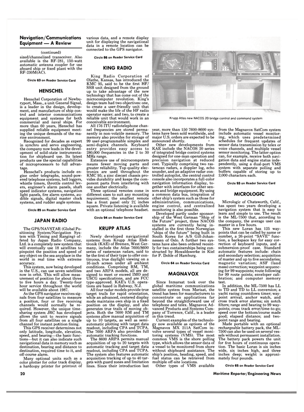
The system also features automatic acquisition tracking of up to 40 targets with guard zones and limitation lines. Since their introduction last year, more than 150 7600-8600 systems have been sold worldwide, and major U.S. orders are expected to be announced shortly. ' Other new developments from KAE include the NACOS 20 series of integrated bridge control systems designed for one-man operation and precision navigation at reduced cost. Typically comprising two rasterscan radars, a doppler log, echo sounder, and an adaptive radar-controlled autopilot, the central control console also incorporates a full-color navigation information display, together with interfaces for other sensors and bridge equipment. By using a common data bus, integration of other ship's system such as those for administration, communications, engine control, and centralized monitoring is also possible.
Developed partly under sponsorship of the West German "Ship of the Future" project, three NACOS systems are currently being installed in the first three Norwegian "ships of the future" being built in South Korea for A/S Gill-Johannessen of Oslo. A further two systems have also been ordered recently for two containerships being constructed by Howaldswerke in Kiel for P. Dohle of Hamburg.
Circle 64 on Reader Service Card MAGNAVOX Since Inmarsat took over the global maritime communications satellite system from Marisat, the trend has been for manufacturers to concentrate on applications far beyond the straightforward use of telephone and telex. Magnavox Advanced Products and Systems Company of Torrence, Calif., is a leader in this trend.
Current examples of the technology now available as options of the Magnavox MX 211A SatCom involve several types of vessel monitoring systems (VMS). The most common VMS is the shore polling type, which allows the sensor data of a vessel to be monitored from shore without shipboard assistance. The ship's position, heading, speed, and fuel status can be retrieved from multiple off-site locations.
Other types of VMS available from the Magnavox SatCom system include automatic vessel monitoring, which uses predetermined schedules for frequent updates of sensor data transmission by telex or voice channels, and multiple vessel sensor monitoring. The latter option can, for example, receive both navigation data and engine status independently, using a dual-port VMS system with separate polling and buffers capable of storing up to 2,000 characters each.
Circle 93 on Reader Service Card MICROLOGIC Micrologic of Chatsworth, Calif., has spent two years developing a navigation system that is easy to learn and simple to use. The result is the ML-7500 that, according to the company, the average user can master in a few hours.
This new Loran has 125 waypoints that can be called by name or number, a 26-point "SAVE" function, a backspace key for easy correction of keyboard inputs, and a submersion-proof case. Standard automatic features include: chain and secondary selection; acquisition of master and up to five secondaries; magnetic variation; ASF (land mass) correction; waypoint sequencing for 99 waypoints; route following for 99 route points; enveloper calibration; and computer memory test.
In addition, the ML-7500 has LL to TD and TD to LL conversion; a yacht racing countdown timer; waypoint arrival, anchor watch, and cross track error alarms; six notch filters; range and bearing to 99 waypoints; cross track error/time-to-go; speed over the bottom/course made good; elapsed distance; and twopoint range and bearing.
Made portable with an optional rechargeable battery pack, the ML- 7500 can also be used on several vessels without permanent installation.
The battery pack powers the unit for five hours of continuous operation.
The basic Loran is six inches wide, six inches high, and three inches deep; weight is approximately four pounds.
Circle 65 on Reader Service Card NAVAL Naval Electronics, Inc. of Tampa, U.S. distributor for Naval Electronics A.B. of Sweden, features its MK 22 AM/FM TV antenna as part of a complete ship's entertainment antenna distribution system.
Free engineering and blueprinting services are offered to shipowners, naval architects, and shipyards.
Naval's service and installation facilities now reach ports in more than 40 countries worldwide.
Naval's master TV antenna systems are omni-directional and do not need rotors as do conventional systems. This allows crew members to watch whichever station they desire without argument as to who controls the rotor. It also allows for superior reception while under way without continuous rotor adjustments to track the TV transmitter on shore. Naval's distribution system places antenna cords and outlets wherever required in messrooms, crew quarters, and other areas.
Naval also supplies a special TV receiver that can be used throughout the world when reception is not possible with a standard American system. This new receiver will operate from PAL, SECAM, and NTSC transmissions, making it truly an international TV set.
Circle 66 on Reader Service Card NAV-COM Busiship is an advanced, computer- based shipboard management information system developed by NAV-COM Incorporated of Deer Park, N.Y., to provide improved operating efficiencies and reduced communications costs for commercial shipping companies.
NAV-COM offers a full suite of applications software with the system, including new programs for onboard spares inventory, crew assignment/ rotation, and vessel administration.
Busiship incorporates a complete package of data communications and electronic mail capabilities.
The result is a system that encourages consistent and standardized reporting practices between ship and shore.
The Busiship system is built around an IBM PC/XT personal computer that has been "ruggedized" by NAV-COM for reliable performance in the shipboard environment.
For ship/shore data exchange and electronic mail, the system uses a 2,400 bps modem and built-in error correction capabilities. It is fully compatible with most standard U.S. and European medium-speed data protocols, including CCITT V.22 bis.
NAV-COM offers a "turnkey" package that includes system de- sign, software development, training, and worldwide service. The company combines the full range of disciplines and technical skills to design, develop, implement, and support complex shipboard computer and communications installations.
Circle 67 on Reader Service Card NAV-CONTROL Nav-Control, Inc. of Halesite, N.Y., is a new firm formed to be the authorized U.S. agent for the navigation/ instrumentation products manufactured by the Norcontrol Division of A/S Kongsberg Vaapenfabrikk in Norway. Nav-Control will also administer certain projects and in-process contracts on behalf of Norcontrol.
One of the major breakthroughs in modern navigation has been the development of the automatic radar plotting aid (ARPA). However, even though the microprocessor-controlled ARPA has landed navigators in the computer age, they still experience environmental pressure following the need for manual plotting and logging during stress situations.
Now, at the touch of a switch, an officer can insure accurate and automatic plotting and logging through the additional features provided for the Norcontrol DataBridge-7 radar navigation and ARPA system. The main innovation has focused on extending the system's unique radar map overlay functions by adding unlimited storage capacity, an X/Y track plotter, and datalogger.
Another optional feature allows radar maps to be stabilized with the aid of navigation data where fixed points for radar tracking are missing.
The map function allows overlays to be constructed that show features not visible on the sea surface, such as wrecks, oil or gas pipelines, traffic separation zones, shallows, and international boundaries. Coast Guard vessels benefit from the capability of recording the position of target vessels including own ship in relation to fishing boundaries or other "invisible" lines.
Norcontrol's DataBridge-7 is a third-generation ARPA that acquires and tracks up to 50 radar targets and continuously displays collision- avoidance data on the most threatening 20. It will sound a collision warning alarm whenever any of these targets exceed user-specified values for closest point of approach and time to closest point of approach.
As a collision-avoidance system, DataBridge-7 meets or exceeds IMO recommendations and U.S.
Coast Guard and Maritime Administration standards.
Circle 98 on Reader Service Card NAVIGATION SCIENCES The Viewnav® master mariner electronic chart system from Navigation Sciences Inc. of Bethesda, Md., is being used increasingly by operators of pilot boats, ferries, tankers, and tugboats who want an extra edge to navigate more accu- rately in difficult harbor conditions.
It is particularly valuable to ferryboat and other operators responsible for passenger safety, who must maintain precise schedules in all kinds of weather.
The Viewnav system combines differential Loran C with radar and NOS-quality, full-color digitized charts, and proprietary software to provide the most complete tactical navigation information possible.
The system uses differential Loran position fixes of own vessel accurate to within five yards. Radar images are superimposed and displayed in water areas to show vessel traffic and other targets.
Buoys, navaids, and channels are shown in actual chart colors. Own ship is a to-scale, vessel-shaped outline, and radar images appear in bright red. When a buoy is off station, the electronic chart shows where the buoy should be while the radar images show where the buoy actually is. The true-motion presentation is displayed in selectable ranges from one to 48 NM square, with automatic electronic chart advancement.
Alphanumeric data appears on-screen, giving speed, course, time, distance, heading to the next waypoint, movable cursor position and more. Keyboard control consoles are available with a f 4-, 20-, or 25-inch CRT color monitor.
Two new products, the Viewnav electronic chart offshore platform monitoring system for oil rig and pipeline traffic management, and the Viewnav harbor monitoring system, have been introduced to meet these stationary marine monitoring applications. To alert rig operators of potential collision danger, and to help them warn ships of potential collision or potential anchorage damage to pipelines, the platform monitoring system offers precise electronic charts of the entire platform and pipeline configuration. An automatic radar plotting aid (ARPA) replaces Loran C in this system, allowing up to 40 targets— ships, boats, even low-flying aircraft— to be simultaneously tracked, identified, and classified.
To airport authorities, pilots' groups, tug companies, and others who must know where vessel traffic is and help guide vessels into and out of harbors, the harbor monitoring system features detailed fullcolor charts and vessel radar returns, including anchorage grids for fast location, tracking, and identification of vessels. The data base can recall and display on-screen alphanumeric information such as arrival/ departure times and pilot names.
Circle 68 on Reader Service Card NEWMAR NEWMAR of Newport Beach, Calif., offers the NAV-222, an automatic digital direction finder for easy and precise navigation. This compact unit utilizes a microprocessor in place of motors or other moving parts, and allows signals to be locked in from either the beacon or broadcast band by a lightweight delta loop antenna mounted permanently on the cabin top or mast.
Two digital LCD displays indicate station frequency to the nearest kHz and relative bearing of the station to the nearest degree. The circular LED display indicates the actual bearing in azimuth to the station.
A rotating azimuth bezel allows relative bearings to be converted to true bearings for simple navigation or homing.
The speaker can be remotely located for maximum audibility, while the processor unit can be tabletop-, overhead-, or bulkhead-mounted.
Circle 92 on Reader Service Card PUROFLOW MARINE Puroflow Marine Corporation of Newport News, Va., manufactures power-line filters that provide essential protection for shipboard communications and navigation systems against harmful voltage surges and noise in ships' mains. Modern, solid-state electronics systems are extremely vulnerable to voltage transients and electromagnetic interference (EMI) that can cause these products to fail or malfunction without warning. It is estimated that voltage fluctuations may be responsible for as much as 60 percent of all service calls for marine electronics equipment.
Puroflow estimates that the average shipowner could save thousands of dollars annually by adding proper power-line protection aboard ship.
The company offers an extensive selection of power-line protection devices, including voltage surge suppressors and EMI/RFI filters. These filters are designed to react within nanoseconds to shunt away harmful overvoltage surges and remove unwanted noise from ships' mains.
The bi-directional, multi-stage filters were originally developed by Puroflow to protect sensitive military electronics systems for the U.S.
Navy. They meet all military specifications for power-line conditioning, including tests for vibration and shock. Filters are available in a wide range of AC and DC voltage capacities.
Circle 69 on Reader Service Card RACAL-DECCA The Racal-Decca Master Radar series is a "building block" radar system that can be configured as a 16-inch relative motion radar and upgraded with modules to add anticollision true motion and automatic radar plotting aid (ARPA) capabilities.
This modular approach gives design and production economies and a wide range of usage applications.
As a result, Master Radar systems meet or exceed IMO standards, but can cost less to buy, upgrade, and service. Purchase and maintenance economy are achieved without performance compromise.
Racal-Decca ARPA technology has been extensively proven in operation around the world. Master Radar capabilities include automatic target tracking and collision-prediction alarms, pre-plotting of trail maneuvers, Cleanscan videoprocessing for best foul weather picture, bright recycled video, and easy-to-use "operator-proof" programming.
To support global operations, Racal- Decca has more than 500 radar service locations worldwide.
Circle 70 on Reader Service Card RADIO-HOLLAND Radio-Holland USA, B.V., Distributor Products Division, Houston, is the exclusive distributor in the U.S. for many quality-oriented communications and navigation equipment suppliers. Sales and service are nationwide through an extensive network of nearly 200 marine dealers, and are also supported through the worldwide network of Radio-Holland B.V. of Amsterdam.
Manufacturers and products represented include the following: S.P. Radio Sailor of Aalborg, Denmark— the compact VHF 25-watt radio RT2047, with full duplex/simplex, 60 private channels, dual watch, and scanning; the 25-watt VHF RT146, full duplex/simplex, 20 private channels, dual watch; the 25-watt VHF RT144AC, simplex/ semi-duplex, five private channels, dual watch; the compact scrambler CRY2001, operates on any VHF/ SSB, double scrambling, 16.8 million code combinations, group calling; the 1000 SSB 400-watt station with auto-tuned coupler, also available with fully automatic radiotelex station with scanning capabilities; and the 500 kHz main/reserve SOLAS station.
From Thrane and Thrane of Copenhagen— TT1600 integrated, automatic radio/telex system including TT1585C ARQ modem with 64K character text editing memory, keyboard processor, video display unit, and hard copy printer.
From Philips of the Netherlands— Pact 250 teleprinter with video display unit, basic electronic memory of 38K characters expandable to 166K characters.
From Kelvin Hughes of England— Series 500 complete X band radar package with peak output of 10 kilowatts available as two- or three-unit system; Series 1600 complete radar package for vessels over 1,600 gross tons, two- or three-unit system with 10 kw output or threeunit system with 25 kw output.
From COMSAT TeleSystems— TSI MCS 9100 maritime satellite communications system. From Odin, Inc.—the NCD-39 real-time electronic charting system. From Radio-Holland B.V. of Amsterdam— RH TR-4750 survival craft radio, RH 4316 VHF omnitester, and RH 4312 video interface unit.
Circle 80 on Reader Service Card RAYTHEON MARINE Raytheon Marine Company of Manchester, N.H., has introduced two new low-cost rasterscan radars so that all workboat operators can benefit from the new technology that has made radar more affordable.
The 3604 and 3610 radars, with maximum ranges of 36 and 64 nautical miles, will also serve as backup units for oceangoing ships.
Using digital rasterscan technology, with high-resolution (512 lines), 12-inch-diagonal TV type displays, the new radars provide sharp, continuous 360-degree pictures that are easy to read from a distance. Standard features include electronic bearing line, variable range marker, SeaGuard intrusion alarm, interference rejection, selectable target expander, and on-screen tuning.
In addition to the new rasterscan radars, of major importance is Raytheon's introduction of a new DSL- 150 doppler speed log that helps workboat and ship operators meet IMO requirements. The highly accurate DSL-150 interfaces with radar, ARPA, satellite navigators, and other equipment, and has a wide range of interfacing remote displays.
The display has a three-digit, red LED readout indicating speed from zero to 30 knots in K„-knot increments. Distance run is indi- cated by a six-digit counter, with manual reset on the front panel.
A new commercial, chart-recording echo sounder has also been introduced to meet IMO requirements for most ships. The RD-500 sounder records and prints depth in six ranges to 1,000 feet, meters, or fathoms, and prints time and event marks on the chart. Digital depth display and pre-settable, audible depth alarm are provided. A 80-kHz transducer is standard.
Other new products from Raytheon include: the RAYAX-500 weather facsimile receiver/recorder; RAYSAT-200 satellite navigator; RAYNAV-750 MK II Loran C navigator; and the RAY-1285 SSB marine radiotelephone.
Circle 71 on Reader Service Card RAYTHEON OCEAN Raytheon Ocean Systems Company of East Providence, R.I., has introduced an inexpensive, microprocessor- based remote display designed for maximum compatibility with the company's established Fathometer® depth sounder and speed log product lines.
The ruggedized display is lightweight and compact for transportability.
It features a splash-proof, corrosion-resistant case, and has an AC/DC option. The unit will ease operation and enhance the performance of Raytheon's DSF-6000 digital survey Fathometer and navigational speed log. The remote display will also perform well in conjunction with other commercially available marine products featuring a compatible interface.
The new instrument has a large liquid crystal display that is clearly viewable in surroundings ranging from bright sunlight to completely darkened environments. Software customization is available, and a "daisy chain" capability for multiple display requirements is built in.
A complete internal self-test is accomplished automatically each time it is turned on.
Remote installation can, under certain conditions, be as far away as 1,000 feet, with mounting on a bulkhead, tabletop, panel, or overhead.
The product is engineered to military specifications for vibration, can withstand shock of 50 Gs for 11 milliseconds, and can function in 100- percent humidity with temperatures ranging from 0 to 70 C.
Circle 72 on Reader Service Card RAYTHEON SERVICE The Marine Department of Raytheon Service Company (RSC), headquartered in Glen Burnie, Md., provides sales, installation, service, and maintenance for a wide variety of marine navigational and communications equipment and systems, including radars, Fathometers, satellite communications, SOLAS radio stations, syro/steering systems, and fuel management systems.
In addition to the head office, RSC operates at eight other locations around the country, in Los Angeles, San Diego, Houston, New Orleans, Norfolk, Baltimore, Philadelphia, and the New York/New Jersey area. The company maintains a million-dollar inventory of spare parts.
Circle 91 on Reader Service Card RDI RDI Radar Devices, Inc. of San Leandro, Calif., a leading manufacturer of guard zone warning equipment, offers several new navigation and communications products.
These include the RDI ARPA I, M10 Collision Avoidance System, Star* Trac Satellite Navigator, and Satcom I Inmarsat Satellite Communications System.
For shipowners having to comply with the mandatory International Maritime Organization (IMO) ARPA fitting, the RDI ARPA I, M10 represents the most economical solution.
The Amendments to the International Convention for the Safety of Life at Sea, SOLAS 1974, adopted by the Maritime Safety Committee in November 1981, state: "Automatic radar plotting aids fitted prior to September 1, 1984 which do not fully conform to the performance standards adopted by the Organization may, at the discretion of the Administration, be retained until January 1, 1991." In simple terms, this statement provides an opportunity for a shipowner to fit an RDI ARPA I to a 12-inch radar and comply with the spirit of the IMO regulations until 1991.
In 1982, the U.S. Coast Guard permitted an add-on ARPA solution for existing 12-inch radars. These ARPA I/12-inch radar combinations may be retained until 1991 when the IMO ARPA specifications take full effect.
The Star* Trac satellite navigator, a commercial satnav at a competitive price, offers 64 navigation displays plus log/gyro interface for a list price of $2,495".
The new RDI Satcom I features a self-prompting keyboard to make operations simple. Designed for use with Inmarsat, the unit can be interfaced wtih the Star* Trac satnav to provide an automatic vessel monitoring system for less than $33,000.
Circle 90 on Reader Service Card REGENCY Regency Electronics, Inc. of Indianapolis, Ind., recently introduced the Polaris MT6500, a synthesized marine band receiver. The unit operates on all U.S. and international channels, 10 weather channels, and has capacity to add up to 10 private channels. The scanning receiver section can be programmed to scan as few as two or as many as all of the marine channels.
All information is entered into the microprocessor through the backlighted, transluscent rubber keyboard.
Channel numbers and prompting information is displayed on the vacuum fluorescent display.
A special feature of the MT6500 is a programmable, dual-priority capability that either automatically reverts to the priority channel when a call is received on beeps to let the operator know there is a call on the priority channel.
The American-made Polaris MT6500 also features a 25/1 watt selector, bright/dim panel light con- trol, digital clock, and reversible mounting bracket.
Circle 73 on Reader Service Card ROBERTSON/KONGSBERG Based on extensive research into microprocessor technology, Robertson/ Kongsberg North America Inc. of Hauppauge, N.Y., has introduced the AP-9 autopilot with adaptive rudder control system for medium to large vessels of all types.
The key feature of the AP-9 is predictive software that computes rudder response characteristics and completely replaces the dead-band principle. Combined with a totally new rudder feedback unit, this virtually eliminates rudder overshoot, resulting in more precise rudder positioning and extremely accurate steering.
The AP-9 uses LCDs to give course information and confirm the status of various control parameters.
The use of touchbutton controls and the ability to take heading information from both magnetic and gyrocompass inputs makes this unit suitable for almost any vessel.
It can take heading input from most popular brands of gyrocompasses, as well as from Robertson's highly accurate SKR-82 gyrocompass.
The AP-9 has a full range of remote controls and rudder angle idicators, as well as extensive selftest features. Optionally, a complete second steering station is available.
Robertson also announces a new member of its microprocessor-controlled autopilot family, the AP40.
This pilot offers extremely simple yet highly accurate steering control for most commercial vessels and large yachts. The unit's design eliminates the need to individually set controls for rudder, counter rudder, etc., which can be a complex operation depending on vessel characteristics.
Instead, a single pushbutton control selects one of the nine preprogrammed steering models that most accurately matches the vessel's characteristics.
The AP40, like all the Robertson autopilots, displays pertinent data on two large LCDs—one giving system status information, the other showing a digital course readout.
The unit has built-in offcourse alarm and rate-of-turn control. It is said to be ideal for new vessel installations and for retrofits. Options include remote controls, watch alarm, and rudder angle indicators.
Circle 245 on Reader Service Card SELESMAR Following an extensive research and development program, Selesmar S.p.A. of Italy is now marketing a high-resolution radar with digital scan converter and rasterscan presentation. While most other rasterscan systems utilize a resolution of 780 pixels, the new Selescan 1024 uses a high definition of 1,024 by 1,024 pixels in up to eight levels of intensity, provided on a standard monochrome display.
The 1024 is produced in all-version, relative motion, true motion, and ARPA models. In the latter case, basic radar and tracking controls have been designed according to the principle "one function-one control," whereas menu control via numeric keyboard has been chosen for additional, non-urgent operation.
The 24-inch screen comprises two sections: a 350-mm diameter, highresolution radar display; and a display presenting pre-selected navigational data. The latter section is also utilized as the interactive medium in menu operation.
Within the radar work station console (designed by ergonomic specialists for either standing or sitting position), a separate microprocessor stores radar video and intelligently analyzes the scenario around a target.
This innovation practically eliminates target swap and makes area surveillance possible.
A second product announced by Selesmar is the new Autotrack 2.
Taking advantage of the technological progress and following wide field experience, the company's wellknown Autotrack ARPA display has been improved for greater simplicity, while maintaining the outstanding quality and operational features, which largely exceed IMO regulations.
Circle 75 on Reader Service Card SHIP ANALYTICS The Seafarers International Union has just commissioned the world's first interactive, color day, night, and dusk visual shiphandling simulators, designed and built by Ship Analytics of North Stonington, Conn.
Located at the Harry Lundeberg School of Seamanship in Piney Point, Md., this facility contains a full bridge simulator and three radar bridge simulators. Ship Analytics utilized its modular Pilotship and Schoolship simulation technology, interfacing visual systems between the full bridge and the radar cubicles.
The Schoolship configuration provides basic shiphandling training capability within a radar cubicle at moderate cost and within a small space. It provides high resolution, color day, night, and dusk visual scenes up to 110 degrees horizontal field of vision, complementary bridge and navigation equipment, and hydrodynamic models interfaced with the radar simulator. The Schoolship configuration can be conveniently upgraded to the Pilotship configuration as training demands increase.
Ship Analytics utilized its Pilotship configuration to provide senior officer shiphandling training capability within the full bridge setting for collision avoidance, piloting, and navigation. Pilotship provides ultra high resolution, color day, night, and dusk visual scenes up to 230 degrees horizontal field including an aft view for tow operations.
Circle 89 on Reader Service Card SIMRAD Simrad, Inc. of Seattle markets the Simrad/Taiyo TD-C338HS automatic direction finder. This unit has a fully synthesized frequency range from 200 kHz to 17.999 mHz, with 100-frequency memory and 100-channel scanning. Frequency is selectable via keyboard or rotary encoder, in 0.1 kHz steps.
Frequency, channel, and signal strength are indicated by digital LED indicators. Bearings are displayed automatically by a CRT indicator, which includes auto-sense control.
The TD-C338HS unit is said to be one of the most advanced, state-ofthe- art MF/HF automatic direction finders available.
Circle 88 on Reader Service Card SI-TEX Marine navigation data obtained by a conventional radar system can be displayed in six different colors on the CRM-1 color radar monitor from SI-TEX of Clearwater, Fla.
The 360-degree presentation is continuous and never fades from view, and the color CRT allows exceptional daylight viewing, even without a hood.
The CRM-1 unit connects to most conventional radar systems, and converts system data into a six-color display depending on the strength of the returning echo. The strongest echoes are displayed in red, medium echoes are yellow, weak signals come in green, and the sea surface is displayed as blue. The variable bearing marker is displayed as a white dotted line, and the variable range marker appears as a white dotted circle. The plot line is black.
The plotting feature helps the operator determine relative bearing, course direction, and speed of moving targets around his vessel. Plotting time can be selected as 15 seconds (fast) or one minute (slow).
Range capability is from one-half to 64 nautical miles, depending on the capability of the master radar.
The CRM-1 can be interfaced with most conventional radars, and can operate up to 50 feet away from the master radar.
An audible proximity alarm warns of a target's entry into a guard zone established by the operator.
Five zones can be selected: full 360-degree radius, 180-degree on the bow, 90-degree on the bow, 180- degree on the port, and 180-degree on the starboard. Distance of range gates can, be from one-half to 64 nautical miles from the vessel.
Circle 87 on Reader Service Card SPERRY To extend the capabilities of speed measurement for various shipboard needs, Sperry Corporation's Aerospace & Marine Group in Charlottesville, Va., now offers the SRD-421 two-axis, doppler speed log.
The new unit is designed to provide superior accuracy for display and transmission of speed, depth, and distance data, meeting the requirements of a wide range of vessels.
It provides information to enhance efficient operations for the bridges of large oceangoing ships, as well as for special application such as dredges, ferries, hydrographic ships, and geophysical vessels.
The SRD-421 has two-axis speed calculation that provides better speed data than a conventional speed log. It calculates distance traveled and depth under the hull with similar accuracy.
Three units comprise the SRD- 421—the master display, the electronics unit, and the transducer.
The master display has touchsensitive switches and easy-to-read LCD displays on its sectionally dimmed front panel. These simple controls allow the operator to select desired units for the three-digit fore/aft or port/starboard speed displays, four-digit depth or time display, three-digit depth alarm display (with audible alarm), and five-digit distance display.
The electronics unit contains the transmit/receive circuitry and provides speed filters that automatically reduce response time needed to track rapid speed changes using another dedicated microprocessor.
The patented lens-type transducer is ony eight inches in diameter. It uses a unique three-beam configuration, as opposed to four-beam transducers, making it more efficient and cost-effective.
Circle 76 on Reader Service Card STANDARD The latest marine VHF radio introduced by Standard Communications Corporation of Los Angeles features a totally new design. Called the Horizon Voyager, the new radio has a compact case measuring 7 by 7 by 1 inches, which houses a 25-watt, all-channel VHF radio, two-station intercom, and six-watt hailer.
The Voyager's innovative, tilting control panel conveniently places controls and the backlighted LCD display at optimum viewing angle no matter where the radio is located— overhead, on, or under the console. Use of control seals, gasketing, and internal circuits sealed with Hemi-Seal®, protect microchips from the corrosive effects of salt water.
The new unit features all channels in each of the U.S., Canadian, and international frequency bands.
Fifteen channels are assigned as auxiliary channels, for use as new frequencies are allocated by the FCC. The on-board microprocessor selects full 25-watt power, or lower 1-watt "in harbor" power automatically on channels 15 and 17. Programming of new frequencies can be handled in the field by Standard's network of authorized marine products dealers.
In addition to communications channels, six direct-select weather channels are provided. A marine priority scan feature permitting simultaneous monitoring of channel 16 and other channels is programmed into the scan memory. An emergency override permits direct selection of channel 16 during emergencies.
The Voyager's memory with scan feature is controlled by the microprocessor, and permits monitoring of all active channels including auxiliary (future) channels. Backup power keeps the memory circuit alive when the main power switch is turned off. A two-station intercom and six-watt hailer may be selected at any time by pressing a single switch.
The unit's large numerical LCD display is a mini-information center in itself. The display shows channel in use, power level, and programs selected. A three-position dimmer enhances visibility in any lighting condition, including bright sunlight.
Circle 77 on Reader Service Card TELEDYNE Teledyne Hastings-Raydist of Hampton, Va., manufacturer of medium- range, precision radiopositioning systems, is currently conducting final testing on its revolutionary TRAK IV system.
Raydist TRAK IV is an improved version of the well-known Raydist DRS radiopositioning system utilizing "atomic clock" frequency standards and state-of-the-art technology to achieve practically unlimited user capability in the rho/rho mode on a single frequency allocation anywhere in the MF/HF band.
The new unit is particularly well suited to radiopositioning applications in which a relatively large number of simultaneous users must operate at ranges up to several hundred kilometers with a geodetic accuracy of a few meters. The rho/ rho (circular) geometry makes the TRAK IV ideal for coastal applications, regardless of whether the coastline is concave, straight, or even convex. The comparatively broad lane widths (typically 100 meters or more) make lane recovery much easier than with other phase comparison systems.
The ability to track up to four LOPs continuously and simultaneously greatly increases system reliability.
When used with the Raydist Director (microcomputer), interchecking is permitted between the redundant position data to achieve a statistically desired "bestfit" position solution and a "figure of merit" indication of probable accuracy.
The Raydist Director also permits op-area initialization so that the correct fractional values of the several LOPs can be established and/or verified in the actual area of operations.
Circle 78 on Reader Service Card TEXAS INSTRUMENTS Texas Instruments of Dallas has announced a new addition to its TI 4100 Navstar navigator product line, an enhancement that makes the Global Positioning System (GPS) more productive as a navigation/ positioning tool.
Called Satplan™, the new software product provides specific satellite visibility times and position dilution of precision (PDOP) information.
It helps the operator select the best time at which the satellites are in a geometry that will produce a more accurate position.
Satplan selects the four best satellites available to the user, and provides information on precise GPS satellite rise and set times, satellite azimuth and elevation, satellite visibility, profile, and the recommended navigation mode.
The benefit to the user is said to be that Satplan displays and prints the information in tabular and graphic form so that a detailed schedule of satellite availability can be quickly prepared, including an analysis of the most efficient times for GPS use in each location and on each date desired.
Using the TI Color Professional or Portable Professional Computer, with 256K RAM and 8087 numerical co-processor, the easy-to-use Satplan complements the TI 4100 GPS receiver. Satplan almanac data can be taken directly from the receiver's display, or can be updated from government or user sources.
Almanac nomenclature is the same as that used by the TI 4100.
Circle 97 on Reader Service Card TRACOR The Bridgestar satellite navigator from Tracor Instruments of Austin, Texas, offers more value for 1985, with outstanding features and an economical price. In addition to all standard navigation functions, the Bridgestar calculates distance and bearing to 15 waypoints, with route planning between any two waypoints, Special software features providethe user with about 10 percent more usable satellite fixes than most other satnav receivers. In addition, a built-in speed and heading interface enables automatic dead reckoning between fixes.
The unit draws a maximum of 1.2 amperes at 12 volts DC. To conserve power, an innovative "Sleep Mode" allows the receiver to go into standby status between satfixes, and drops power usage to 0.2 amps. The receiver will then "wake up" 20 minutes before the next satellite pass and be ready to calculate the next fix.
Continuous, accurate navigation data translates into time and fuel savings for an oceangoing vessel.
Tracor's integrated Bridgestar satnav and Omega navigator, mounted on a single yoke, provide this essential information, with updates every 60 seconds. This compact, low-cost global navigation system combines the advantages of both satnav and Omega.
The greatest advantage of the Bridgestar is its very accurate position- fix capability. At each satellite fix, the Omega navigator is automatically updated by the satnav receiver.
Between satellite fixes, the Omega receiver provides continuous navigation data as an invaluable aid to satnav dead reckoning. Because the system is comprised of two stand-alone units that can also operate independently, the user is assured of having a dependable navigation system available at all times.
Circle 79 on Reader Service Card TRIMBLE The Model 300 Loran computer offered by Trimble Navigation, Ltd.
of Mountain View, Calif., is the Loran that continues navigating even where no Loran signals exist.
The unit dead reckons position right through the signal interruptions that make other Lorans useless.
It provides a constantly updated estimate of position even when the Trimble's normal Loran positioning capability is unavailable.
The Model 300 will stand alone as a principal electronic aid to navigation or it may be the centerpiece of an integrated navigation system. Its dead-reckoning software package assumed the chore of recording estimated positions and calculates set and drift, utilizing external inputs of speed, heading, and time from a known position.
A track mode permits automatic tracking of the last nine Loran fixes at whatever time intervals required, and the last 10 satnav fixes with its corresponding Loran fix. This function may be invaluable in knowing a precise starting position for the dead-reckoning calculations or for retracing the course just traveled.
The Model 300 stand-alone package includes interface capabilities for satnav, wind and speed instrumentations, autopilots, CDI, plotters, RS 422 for computers, external alarms, external speed and heading transducers, and the Trimble fullfunction remote display. Also available is the optional Hewlett-Packard interface loop for handheld or personal computers. This interface is like having a handheld remote controller.
Circle 96 on Reader Service Card II Morrow II Morrow Inc. of Salem, Ore., is a leading manufacturer of marine navigation equipment, specializing in the production of Loran C receivers and XY track plotters.
The Avenger III Loran C receiver is the most recent additon to the company's product line. This unit is one of the smallest and more compact Loran C receivers, providing high accuracy and great repeatability.
Features offered include current L/L, current LOP, 100 waypoints in L/L and LOPs, full navigation computer with bearing to destination in degrees, speed over bottom in knots, range in nautical miles, ground track in degrees, time to destination in minutes, cross track error, and point-to-point bearing and range between any two of the 100 waypoints.
The unit also offers anchor watch, arrival alert, SRN and BCD display, magnetic variation adjustment, ASF adjustment, and five-year, nonvolatile memory. It also features a universal power supply operating on any dc input from 6.5 to 48 volts.
The Avenger III comes with a full two-year warranty, one of the best in the industry, and is priced at $1,295.
II Morrow also manufactures the Mariner M-33 track plotter, which provides a permanent hard-copy record of a vessel's track on any 8'/- by 11-inch sheet of paper or chart.
This unit can even draw LOP grids on any scale to produce navigation charts.
Circle 172 on Reader Service Card
Read Navigation & Communications Equipment — A R e v i e w— in Pdf, Flash or Html5 edition of May 15, 1985 Maritime Reporter
Other stories from May 15, 1985 issue
Content
- Scheidt Named Marketing And Sales Vice President For American Steamship page: 5
- Radio-Holland USA, B.V. Automates Coastal Station WLO's Radiotelex Service page: 5
- Terry Announces New GLT Single-Stage Turbine page: 6
- NEW GHH-Constructed Drydock, Mission Bay, For Continental Maritime page: 8
- Free Brochure From Baldt Details Moor-Free™ Rapid Release System page: 8
- Korobov Elected Vice President-Finance For COMSAT TeleSystems— Mutnick Named Controller page: 10
- Tano Receives Additional Coast Guard Contract Valued At $2.7 Million page: 10
- Daewoo Wins $16.5-Million Contract To Build Offshore Vessel For India page: 10
- Exclusive Rep For Danish Firm Introduces Radiotelephone System page: 10
- Weerts Named Senior Program Manager For American Systems page: 11
- ABS Developing New Computer Programs To Aid Ship Designers page: 11
- Smith Appointed Senior Vice President For American Steamship page: 14
- Bohme Named Product Development Manager For Simpson Timber page: 14
- Joseph Joins COMSAT As Executive Vice President page: 14
- Lundberg Reappointed Director General Of INMARSAT page: 16
- Literature Available On Clemco Industries' 'Educt-O-Matic' page: 16
- Hubbard Named To Newly Created Position At American President Lines page: 16
- SNAME Introduces New Quarterly— The Journal Of Ship Production page: 16
- Cambridge Instruments Completes New Plant page: 16
- Navigation & Communications Equipment — A R e v i e w— page: 18
- Elliott White Gill Thrusters Offer Unique Advantages page: 32
- Tompkins To Market BFGoodrich Bearings In Four Eastern States page: 33
- Los Angeles SNAME And ASNE Sections Meet In Joint Session page: 34
- Literature Available On FIRE-PREP® 2012 From Nalco Chemical page: 34
- Skantek Announces SK-401, An OCR Software Technology Breakthrough page: 34
- John Crane Offers Literature On Their Line Of Bellows Seals page: 34
- Flakt Offers 20-Page Brochure On Facilities And Capabilities page: 36
- Clemco Pipe Cleaning Tools Blast-Clean Pipe Interior Without Rotating The Pipe page: 39
- Hitachi Delivers Jackup Rig Built For O N G C Of India page: 39
- PRC Announces Availability Of New Family Of Mercaptan Functional Polymers page: 40
- New Boiler Cleaning Technique Offers Savings For Vessel Owners page: 45
- Gulfport Orders Second Paceco Container Crane page: 45
- Brochure Available On HF-SSB Radio Products From Harris Corporation page: 45
- Halter Marine Awarded $85-Million Navy Contract To Build Six T-AGOS Ships page: 46
- Bailey Joins Selkirk Metalbestos As Staff Engineer For Piping Line page: 46
- Zito Named Vice President- Marketing & Development Of COMSAT Technology page: 46
- No Claims Yet On Cat's Over-The-Counter Parts Availability Guarantee page: 46
- Racal Wins $2.8-Million For Marine Simulators page: 46
- McTighe Offers Brochure On High-Flow & Low-Flow Oil/Water Separators page: 46
