
HYPACK Barge Management System
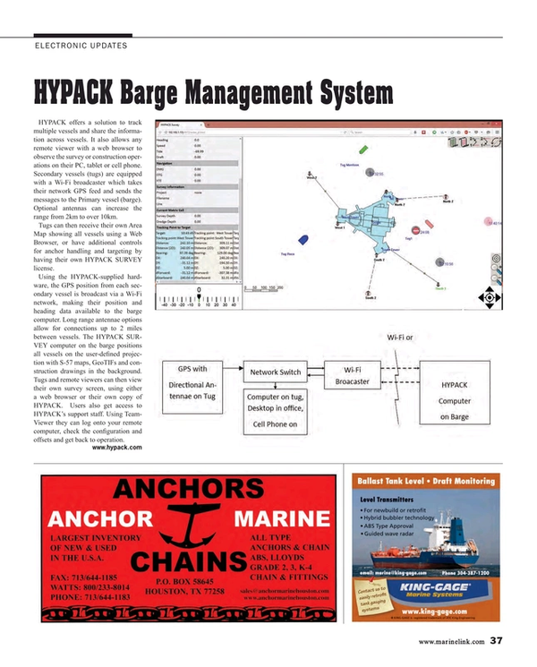
HYPACK offers a solution to track multiple vessels and share the information across vessels. It also allows any remote viewer with a web browser to observe the survey or construction operations on their PC, tablet or cell phone. Secondary vessels (tugs) are equipped with a Wi-Fi broadcaster which takes their network GPS feed and sends the messages to the Primary vessel (barge). Optional antennas can increase the range from 2km to over 10km.
Tugs can then receive their own Area Map showing all vessels using a Web Browser, or have additional controls for anchor handling and targeting by having their own HYPACK SURVEY license.
Using the HYPACK-supplied hardware, the GPS position from each secondary vessel is broadcast via a Wi-Fi network, making their position and heading data available to the barge computer. Long range antennae options allow for connections up to 2 miles between vessels. The HYPACK SURVEY computer on the barge positions all vessels on the user-defined projection with S-57 maps, GeoTIFs and construction drawings in the background. Tugs and remote viewers can then view their own survey screen, using either a web browser or their own copy of HYPACK. Users also get access to HYPACK’s support staff. Using TeamViewer they can log onto your remote computer, check the configuration and offsets and get back to operation.
www.hypack.com
(As published in the July 2015 edition of Maritime Reporter & Engineering News - http://magazines.marinelink.com/Magazines/MaritimeReporter)
Read HYPACK Barge Management System in Pdf, Flash or Html5 edition of July 2015 Maritime Reporter
Other stories from July 2015 issue
Content
- DNV GL: ‘Big Data’ Evolving Fast; LNG Slower than Expected page: 10
- Fuel Efficiency: The Way Forward page: 12
- Preventing Loss of Propulsion After Fuel Switch to Low Sulfur Distillate Fuel page: 14
- How to Defend against Patent Trolls without Breaking the Bank page: 16
- Shore Leave: Re-think on Balancing Security, Seafarer Rights page: 18
- “FS3” Motion-based Simulator for Dutch Navy page: 20
- Big Data: Big Value or Big Risk? page: 21
- Björn Rosengren: Power Boss (Part II) page: 22
- The Maritime Launch of Big Data page: 26
- Building Out on Big Data page: 30
- Maritime & Shipbuilding Italian Style page: 32
- Two-Stroke DF Engine Passes Critical Test page: 34
- The 'Hour of Power': Hybrid Marine Technology & Green Ports page: 35
- Specialty Motors Keep Shipping Afloat page: 36
- HYPACK Barge Management System page: 37
- Simrad Launches New Pro Line Products page: 38
- Pneumatic Band Saw page: 40
- Portable Hydraulic Drills page: 40
- Verotec’s VMEbus Systems page: 40
- Silvagrip page: 40
- Protea Heavy Lift Cranes page: 40
- Senesco Invests in New Welding System page: 40
- PYPLOK: An Alternative to Welding page: 40
- Ballast Water Compliance Tools page: 41
- Tero Marine Wins Boa Contract page: 41
- MarineNav Rack Mount Computers Range page: 41
- New Transas Pilot PRO page: 41
- Coxreels Debuts New Reel Design with 1600 Series page: 41
- Lowrance Announces Software Updates page: 41
- Almarin: 85 Years Strong page: 47
