
Page 32: of Offshore Engineer Magazine (Oct/Nov 2014)
Read this page in Pdf, Flash or Html5 edition of Oct/Nov 2014 Offshore Engineer Magazine
 31
31
 33
33
a survey, and the capability to attenuate high levels of noise allows deployment of
Improved more powerful steering devices that exert stronger lateral forces. The dynamic spread control (DSC) system uses current informa- tion and data from a dense in-sea real-time reservoir monitoring acoustic positioning network to auto- matically and independently steer vessels,
Geology & Geophysics sources and streamers to achieve an accu- using towed-streamer seismic rate repeat of a previous survey. During a repeat survey in the North Sea, despite
Schlumberger’s less predictable ocean currents and higher
Patrick Smith natural feather relative to the baseline sur- vey, DSC enabled 95% of source positions reviews technological to be within 2.5m of planned positions. developments that are
Streamer feather angle was repeated within increasing the accuracy a margin of less than 2.5° for 95% of the time. A further bene? t of point-receiver of 4D seismic reservoir recording is that ? lters can be applied to monitoring.
emulate the spatial frequency response of previous surveys acquired using conven- tional hydrophone arrays.
Corrections for variations in sea level due to tides can be applied either using tide table predictions, in which case correction for atmospheric pressure is advisable, or from differential global
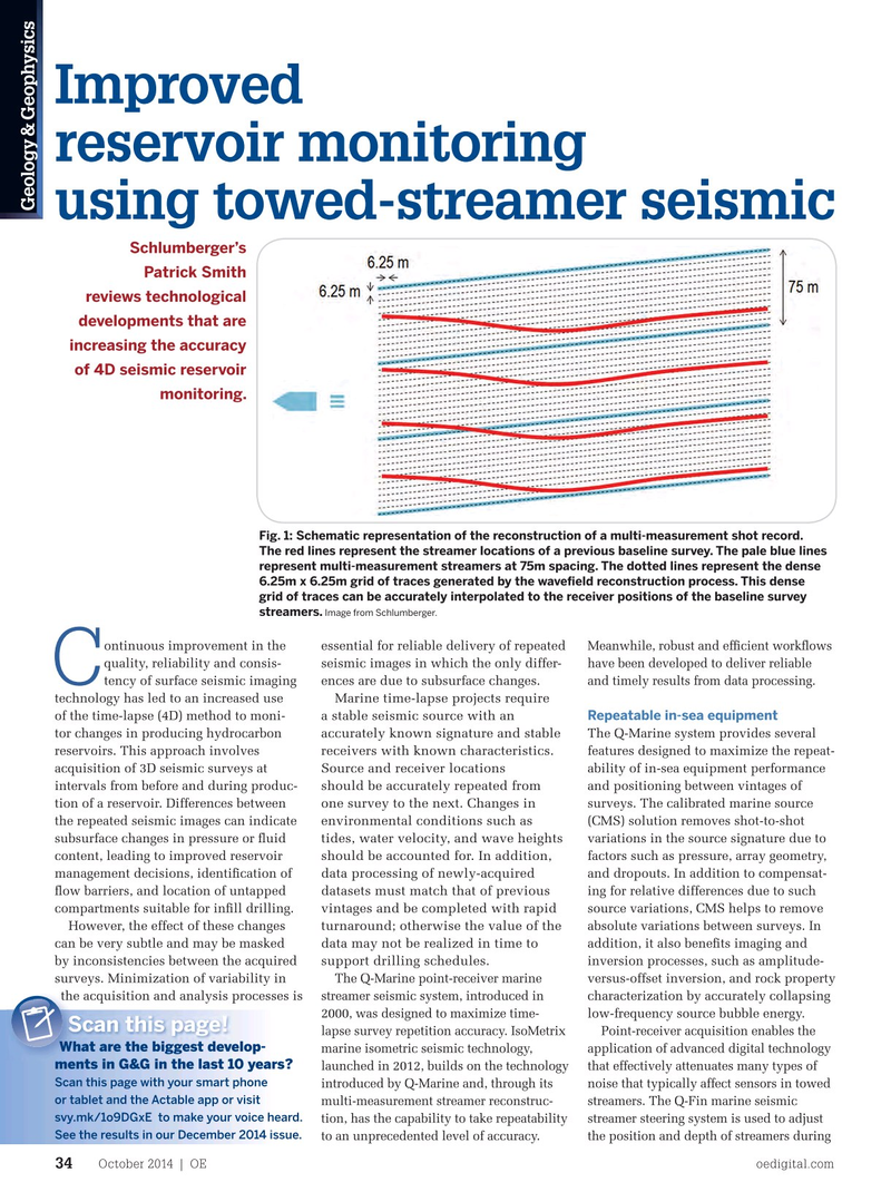
Fig. 1: Schematic representation of the reconstruction of a multi-measurement shot record. positioning system (DGPS) tide height
The red lines represent the streamer locations of a previous baseline survey. The pale blue lines measurements, which typically provide represent multi-measurement streamers at 75m spacing. The dotted lines represent the dense 10-15cm accuracy. Wave height correc- 6.25m x 6.25m grid of traces generated by the wave? eld reconstruction process. This dense tion can be calculated and applied during grid of traces can be accurately interpolated to the receiver positions of the baseline survey data processing to address perturbations streamers. Image from Schlumberger. in the seismic measurements induced by ontinuous improvement in the the roughness of the sea surface, which essential for reliable delivery of repeated
Meanwhile, robust and ef? cient work? ows quality, reliability and consis- become signi? cant once other survey rep- seismic images in which the only differ- have been developed to deliver reliable
C tency of surface seismic imaging etition challenges have been addressed. ences are due to subsurface changes. and timely results from data processing.
Marine time-lapse projects require technology has led to an increased use Variations in seismic velocity through the
Repeatable in-sea equipment a stable seismic source with an of the time-lapse (4D) method to moni- water layer resulting from factors such as
The Q-Marine system provides several tor changes in producing hydrocarbon temperature or salinity can be accounted accurately known signature and stable features designed to maximize the repeat- reservoirs. This approach involves for using measurements from a moving receivers with known characteristics. ability of in-sea equipment performance acquisition of 3D seismic surveys at vessel pro? ler on the seismic vessel to
Source and receiver locations and positioning between vintages of intervals from before and during produc- derive a unique space- and depth-variant should be accurately repeated from surveys. The calibrated marine source tion of a reservoir. Differences between water column velocity for each sail line. one survey to the next. Changes in (CMS) solution removes shot-to-shot the repeated seismic images can indicate Accurate survey repetition minimizes the environmental conditions such as variations in the source signature due to subsurface changes in pressure or ? uid need for statistical matching processes, tides, water velocity, and wave heights factors such as pressure, array geometry, content, leading to improved reservoir and deterministic time-lapse processing should be accounted for. In addition, and dropouts. In addition to compensat- management decisions, identi? cation of work? ows have been developed that take data processing of newly-acquired ing for relative differences due to such ? ow barriers, and location of untapped advantage of this to ensure that the 4D datasets must match that of previous source variations, CMS helps to remove compartments suitable for in? ll drilling. seismic measurements are accurate from vintages and be completed with rapid
However, the effect of these changes absolute variations between surveys. In surface to below the reservoir. turnaround; otherwise the value of the can be very subtle and may be masked addition, it also bene? ts imaging and data may not be realized in time to
Multi-measurement by inconsistencies between the acquired inversion processes, such as amplitude- support drilling schedules.
streamer reconstruction
The Q-Marine point-receiver marine surveys. Minimization of variability in versus-offset inversion, and rock property streamer seismic system, introduced in the acquisition and analysis processes is the acquisition and analysis processes is characterization by accurately collapsing With modern steering technology, source 2000, was designed to maximize time- low-frequency source bubble energy. locations can be repeated from one
Scan this page!Scan this page!
survey to the next to within around 2m; lapse survey repetition accuracy. IsoMetrix Point-receiver acquisition enables the
What are the biggest develop-What are the biggest develop- however, even with streamer steering, marine isometric seismic technology, application of advanced digital technology ments in G&G in the last 10 years? ments in G&G in the last 10 years? it can be dif? cult to consistently repeat launched in 2012, builds on the technology that effectively attenuates many types of
Scan this page with your smart phone receiver locations. It is common to introduced by Q-Marine and, through its noise that typically affect sensors in towed or tablet and the Actable app or visit minimize receiver positioning errors by multi-measurement streamer reconstruc- streamers. The Q-Fin marine seismic svy.mk/1o9DGxE to make your voice heard. deploying streamers at half the spacing tion, has the capability to take repeatability streamer steering system is used to adjust
See the results in our December 2014 issue. of the baseline survey, but this increases to an unprecedented level of accuracy. the position and depth of streamers during
October 2014 | OE oedigital.com 34 034_OE1014_G&G1_SLB.indd 34 9/23/14 11:43 AM