
Page 33: of Offshore Engineer Magazine (Oct/Nov 2014)
Read this page in Pdf, Flash or Html5 edition of Oct/Nov 2014 Offshore Engineer Magazine
 32
32
 34
34
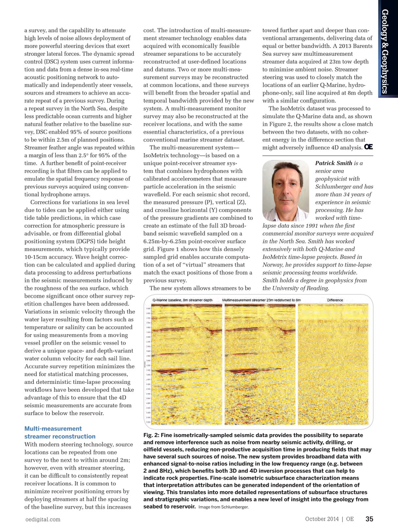
Geology & Geophysics a survey, and the capability to attenuate cost. The introduction of multi-measure- towed further apart and deeper than con- high levels of noise allows deployment of ment streamer technology enables data ventional arrangements, delivering data of more powerful steering devices that exert acquired with economically feasible equal or better bandwidth. A 2013 Barents stronger lateral forces. The dynamic spread streamer separations to be accurately Sea survey saw multimeasurement control (DSC) system uses current informa- reconstructed at user-defned locations streamer data acquired at 23m tow depth tion and data from a dense in-sea real-time and datums. Two or more multi-mea- to minimise ambient noise. Streamer acoustic positioning network to auto- surement surveys may be reconstructed steering was used to closely match the matically and independently steer vessels, at common locations, and these surveys locations of an earlier Q-Marine, hydro- sources and streamers to achieve an accu- will beneft from the broader spatial and phone-only, sail line acquired at 8m depth rate repeat of a previous survey. During temporal bandwidth provided by the new with a similar confguration.
a repeat survey in the North Sea, despite system. A multi-measurement monitor The IsoMetrix dataset was processed to less predictable ocean currents and higher survey may also be reconstructed at the simulate the Q-Marine data and, as shown natural feather relative to the baseline sur- receiver locations, and with the same in Figure 2, the results show a close match vey, DSC enabled 95% of source positions essential characteristics, of a previous between the two datasets, with no coher- to be within 2.5m of planned positions. conventional marine streamer dataset. ent energy in the difference section that
Streamer feather angle was repeated within
The multi-measurement system— might adversely infuence 4D analysis. a margin of less than 2.5° for 95% of the
IsoMetrix technology—is based on a
Patrick Smith is a time. A further beneft of point-receiver unique point-receiver streamer sys- senior area recording is that flters can be applied to tem that combines hydrophones with geophysicist with emulate the spatial frequency response of calibrated accelerometers that measure
Schlumberger and has previous surveys acquired using conven- particle acceleration in the seismic more than 34 years of tional hydrophone arrays.
wavefeld. For each seismic shot record,
Corrections for variations in sea level the measured pressure (P), vertical (Z), experience in seismic due to tides can be applied either using and crossline horizontal (Y) components processing. He has tide table predictions, in which case of the pressure gradients are combined to worked with time- correction for atmospheric pressure is create an estimate of the full 3D broad- lapse data since 1991 when the frst advisable, or from differential global band seismic wavefeld sampled on a commercial monitor surveys were acquired
Fig. 1: Schematic representation of the reconstruction of a multi-measurement shot record. positioning system (DGPS) tide height 6.25m-by-6.25m point-receiver surface in the North Sea. Smith has worked
The red lines represent the streamer locations of a previous baseline survey. The pale blue lines measurements, which typically provide grid. Figure 1 shows how this densely extensively with both Q-Marine and represent multi-measurement streamers at 75m spacing. The dotted lines represent the dense 10-15cm accuracy. Wave height correc- sampled grid enables accurate computa-
IsoMetrix time-lapse projects. Based in 6.25m x 6.25m grid of traces generated by the wavefeld reconstruction process. This dense tion can be calculated and applied during tion of a set of “virtual” streamers that
Norway, he provides support to time-lapse grid of traces can be accurately interpolated to the receiver positions of the baseline survey data processing to address perturbations match the exact positions of those from a seismic processing teams worldwide. streamers. Image from Schlumberger. in the seismic measurements induced by previous survey.
Smith holds a degree in geophysics from
Meanwhile, robust and effcient workfows the roughness of the sea surface, which The new system allows streamers to be the University of Reading.
have been developed to deliver reliable become signifcant once other survey rep- and timely results from data processing. etition challenges have been addressed.
Variations in seismic velocity through the
Repeatable in-sea equipment water layer resulting from factors such as
The Q-Marine system provides several temperature or salinity can be accounted features designed to maximize the repeat- for using measurements from a moving ability of in-sea equipment performance vessel profler on the seismic vessel to and positioning between vintages of derive a unique space- and depth-variant surveys. The calibrated marine source water column velocity for each sail line. (CMS) solution removes shot-to-shot Accurate survey repetition minimizes the variations in the source signature due to need for statistical matching processes, factors such as pressure, array geometry, and deterministic time-lapse processing and dropouts. In addition to compensat- workfows have been developed that take ing for relative differences due to such advantage of this to ensure that the 4D source variations, CMS helps to remove seismic measurements are accurate from absolute variations between surveys. In surface to below the reservoir. addition, it also benefts imaging and
Multi-measurement inversion processes, such as amplitude-
Fig. 2: Fine isometrically-sampled seismic data provides the possibility to separate streamer reconstruction versus-offset inversion, and rock property and remove interference such as noise from nearby seismic activity, drilling, or characterization by accurately collapsing With modern steering technology, source oilfeld vessels, reducing non-productive acquisition time in producing felds that may low-frequency source bubble energy. locations can be repeated from one have several such sources of noise. The new system provides broadband data with
Point-receiver acquisition enables the survey to the next to within around 2m; enhanced signal-to-noise ratios including in the low frequency range (e.g. between application of advanced digital technology however, even with streamer steering, 2 and 8Hz), which benefts both 3D and 4D inversion processes that can help to that effectively attenuates many types of it can be diffcult to consistently repeat indicate rock properties. Fine-scale isometric subsurface characterization means noise that typically affect sensors in towed receiver locations. It is common to that interpretation attributes can be generated independent of the orientation of streamers. The Q-Fin marine seismic minimize receiver positioning errors by viewing. This translates into more detailed representations of subsurface structures streamer steering system is used to adjust deploying streamers at half the spacing and stratigraphic variations, and enables a new level of insight into the geology from seabed to reservoir.
Image from Schlumberger. the position and depth of streamers during of the baseline survey, but this increases oedigital.com October 2014 | OE 35 034_OE1014_G&G1_SLB.indd 35 9/23/14 11:43 AM