
Page 38: of Offshore Engineer Magazine (Oct/Nov 2014)
Read this page in Pdf, Flash or Html5 edition of Oct/Nov 2014 Offshore Engineer Magazine
 37
37
 39
39
Drilling Mapping while drilling goes live
In May 2014,
Schlumberger announced the introduction of its
GeoSphere reservoir mapping-while-drilling service. Claudio Paschoa discussed the new technology with Jean
Seydoux, well placement and reservoir positioning program manager for
Drilling & Measurements,
Schlumberger, based in
Brazil.
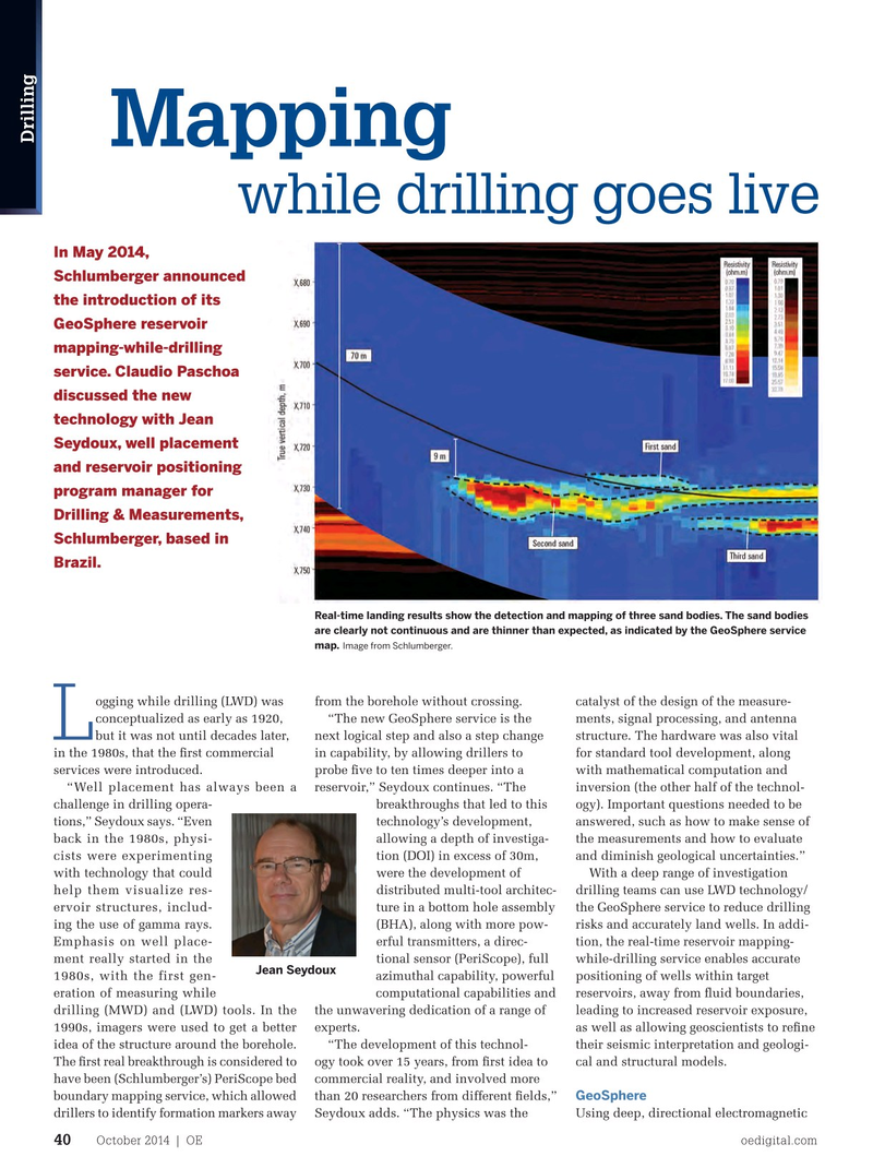
Real-time landing results show the detection and mapping of three sand bodies. The sand bodies are clearly not continuous and are thinner than expected, as indicated by the GeoSphere service Image from Schlumberger. map.
ogging while drilling (LWD) was from the borehole without crossing. catalyst of the design of the measure- conceptualized as early as 1920, “The new GeoSphere service is the ments, signal processing, and antenna
L but it was not until decades later, next logical step and also a step change structure. The hardware was also vital in the 1980s, that the frst commercial in capability, by allowing drillers to for standard tool development, along services were introduced. probe fve to ten times deeper into a with mathematical computation and “Well placement has always been a reservoir,” Seydoux continues. “The inversion (the other half of the technol- challenge in drilling opera- breakthroughs that led to this ogy). Important questions needed to be tions,” Seydoux says. “Even technology’s development, answered, such as how to make sense of back in the 1980s, physi- allowing a depth of investiga- the measurements and how to evaluate cists were experimenting tion (DOI) in excess of 30m, and diminish geological uncertainties.” with technology that could were the development of With a deep range of investigation help them visualize res- distributed multi-tool architec- drilling teams can use LWD technology/ ervoir structures, includ- ture in a bottom hole assembly the GeoSphere service to reduce drilling ing the use of gamma rays. (BHA), along with more pow- risks and accurately land wells. In addi-
Emphasis on well place- erful transmitters, a direc- tion, the real-time reservoir mapping- ment really started in the tional sensor (PeriScope), full while-drilling service enables accurate
Jean Seydoux 1980s, with the first gen- azimuthal capability, powerful positioning of wells within target eration of measuring while computational capabilities and reservoirs, away from fuid boundaries, drilling (MWD) and (LWD) tools. In the the unwavering dedication of a range of leading to increased reservoir exposure, 1990s, imagers were used to get a better experts. as well as allowing geoscientists to refne idea of the structure around the borehole. “The development of this technol- their seismic interpretation and geologi-
The frst real breakthrough is considered to ogy took over 15 years, from frst idea to cal and structural models.
have been (Schlumberger’s) PeriScope bed commercial reality, and involved more
GeoSphere boundary mapping service, which allowed than 20 researchers from different felds,” drillers to identify formation markers away Seydoux adds. “The physics was the Using deep, directional electromagnetic
October 2014 | OE oedigital.com 40 000_OE1014_D&C2_Claudio.indd 40 9/23/14 1:29 PM