
Satellite Images Capture Tanker Pollution
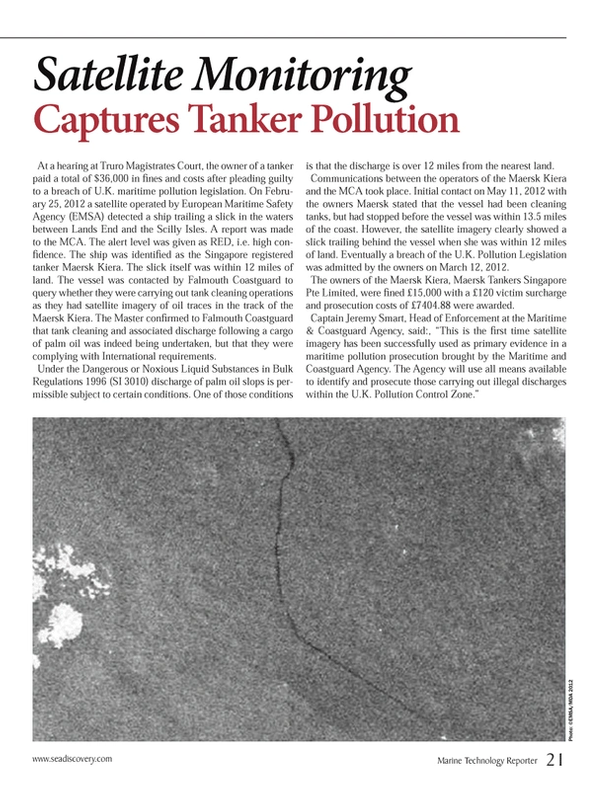
At a hearing at Truro Magistrates Court, the owner of a tanker paid a total of $36,000 in fines and costs after pleading guilty to a breach of U.K. maritime pollution legislation. On February 25, 2012 a satellite operated by European Maritime Safety Agency (EMSA) detected a ship trailing a slick in the waters between Lands End and the Scilly Isles. A report was made to the MCA. The alert level was given as RED, i.e. high confidence. The ship was identified as the Singapore registered tanker Maersk Kiera. The slick itself was within 12 miles of land. The vessel was contacted by Falmouth Coastguard to query whether they were carrying out tank cleaning operations as they had satellite imagery of oil traces in the track of the Maersk Kiera. The Master confirmed to Falmouth Coastguard that tank cleaning and associated discharge following a cargo of palm oil was indeed being undertaken, but that they were complying with International requirements.
Under the Dangerous or Noxious Liquid Substances in Bulk Regulations 1996 (SI 3010) discharge of palm oil slops is permissible subject to certain conditions. One of those conditions is that the discharge is over 12 miles from the nearest land.
Communications between the operators of the Maersk Kiera and the MCA took place. Initial contact on May 11, 2012 with the owners Maersk stated that the vessel had been cleaning tanks, but had stopped before the vessel was within 13.5 miles of the coast. However, the satellite imagery clearly showed a slick trailing behind the vessel when she was within 12 miles of land. Eventually a breach of the U.K. Pollution Legislation was admitted by the owners on March 12, 2012.
The owners of the Maersk Kiera, Maersk Tankers Singapore Pte Limited, were fined £15,000 with a £120 victim surcharge and prosecution costs of £7404.88 were awarded.
Captain Jeremy Smart, Head of Enforcement at the Maritime & Coastguard Agency, said, “This is the first time satellite imagery has been successfully used as primary evidence in a maritime pollution prosecution brought by the Maritime and Coastguard Agency. The Agency will use all means available to identify and prosecute those carrying out illegal discharges within the U.K. Pollution Control Zone.”
(As published in the October 2013 edition of Marine Technology Reporter - www.seadiscovery.com)
Read Satellite Images Capture Tanker Pollution in Pdf, Flash or Html5 edition of October 2013 Marine Technology
Other stories from October 2013 issue
Content
- Increase in Demand for the Hot Subsea Vessel Market page: 8
- Oceaneering Taps BAE Systems to Build New Subsea Support Vessel page: 12
- Van Oord Contracts Damen for DP2 Cable Laying Vessel page: 14
- MHI to Build RV for JAMSTEC page: 14
- OSD-IMT Wins Contracts for COSL page: 16
- IHC Merwede Launches Pipelaying Vessel page: 17
- Cyclops: A Revolutionary Hull Design page: 18
- Floating LiDAR System page: 20
- Satellite Images Capture Tanker Pollution page: 21
- Baltic Wind Success Paves Way for Ecosse page: 23
- National Ocean Policy, Coastal & Marine Spatial Planning Raising Red Flags page: 24
- One-on-One with SMAST’s Steven E. Lohrenz page: 26
- From Learning to Earning page: 30
- AUV Deployment by the U.S. Navy 5th Fleet page: 36
- ICTINEU 3 Development of a Research Submersible page: 38
- ARGUS Enviable Technology, Unlimited Potential page: 42
- Improved eBird page: 52
- New Additions to Imagenex Line page: 52
- AMEC Buys AXYS Sensor page: 52
- The Cavidome page: 52
- GE Dynamic Positioning page: 53
- Seatronics, CodaOctopus Agree page: 54
- Shark Eye page: 54
- CTI SonarWiz Update page: 54
- Compact Survey AUV page: 55
- New NEXUS HD Multiplexer from MacArtney page: 56
- Tritech’s RAMS Integrity Monitoring Technology page: 56
- Mustang Launches Ocean Commander Immersion Suit page: 56
- Reservoir Modeling Platform page: 56
- MacArtney Inline Termination for Andritz Hydro Hammerfest page: 57
- EIVA: New Winch Range page: 58
- MetOcean Snow Beacon page: 58
- Free Web-Embeddable Map Widgets page: 58