
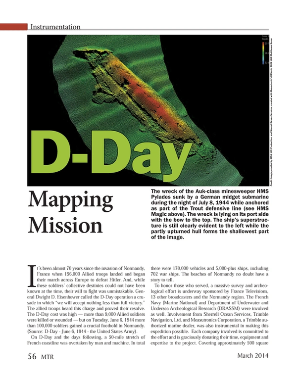
D-Day Mapping Mission
It’s been almost 70 years since the invasion of Normandy, France when 156,000 Allied troops landed and began their march across Europe to defeat Hitler. And, while these soldiers’ collective destinies could not have been known at the time, their will to fight was unmistakable. General Dwight D. Eisenhower called the D-Day operation a crusade in which “we will accept nothing less than full victory.” The allied troops heard this charge and proved their resolve. The D-Day cost was high — more than 9,000 Allied soldiers were killed or wounded — but on Tuesday, June 6, 1944 more than 100,000 soldiers gained a crucial foothold in Normandy. (Source: D-Day - June 6, 1944 - the United States Army).
On D-Day and the days following, a 50-mile stretch of French coastline was overtaken by man and machine. In total there were 170,000 vehicles and 5,000-plus ships, including 702 war ships. The beaches of Normandy no doubt have a story to tell.
To honor those who served, a massive survey and archeological effort is underway sponsored by France Televisions, 13 other broadcasters and the Normandy region. The French Navy (Marine National) and Department of Underwater and Undersea Archeological Research (DRASSM) were involved as well. Involvement from Sherrell Ocean Services, Trimble Navigation, Ltd. and Measutronics Corporation, a Trimble authorized marine dealer, was also instrumental in making this expedition possible. Each company involved is committed to the effort and is graciously donating their time, equipment and expertise to the project. Covering approximately 500 square kilometers, this will be the largest continuous survey of this type ever completed in the region. Together, these groups are building a complete GIS database of the area based around the five invasion beaches of D-Day. The volunteers are sharing their professional expertise to preserve the Normandy beaches’ history as well as capture 3D images of the historic assets.
Through their survey and mapping work, the team is working to have the Normandy D-Day invasion coastline designated as a UNESCO World Heritage Site by the World Heritage Committee. A UNESCO World Heritage Site is a location that is identified as having special cultural or physical significance, not to a single nation, but to the world.
Beaches of Normandy - Survey
The Discovery Phase of the mapping expedition started in July 2013 with a catamaran and crew leaving from Port of Saint-Malo, France. The total survey effort took nearly seven weeks and involved bathymetric mapping with an EdgeTech interferometric multibeam / side scan sonar combined with the Trimble SPS855/555H GNSS modular heading bundle and an inertial motion reference unit (MRU). The Trimble SPS heading bundle outputs the position, heading and timing synchronization data to the multibeam data collection and processing software. Here it is stored and time-tagged to the sonar data. Geo-referenced point cloud and side scan data are displayed real time for review by the system operator as well as logged for further data editing, processing and mapping.
The Trimble SPS series heading bundle antenna array was mounted on center with the transducer mount pole near the bow of the catamaran vessel. A custom mount was developed and built to allow the entire survey sensor package to be retracted when entering or departing local ports, which have limited hull clearances, dependent upon tides. The interferometric sonar system afforded wide swath “point cloud” coverage for three-dimensional modeling and also provided side scan planimetric imagery to aid in target identification.
Measutronics Corporation, Trimble’s leading U.S. Marine dealer, was chosen for this project because of its experience in the field of marine guidance, mapping, imaging and equipment holdings. Lou Nash, Measutronic’s founder, explains that the GNSS heading bundle is critical to the bathymetric systems because, “without accurate positioning, you essentially don’t have a reference point or know where you are in relation to anything else; as a result you can’t accurately and efficiently trace back to targets in the water. In addition, the ‘motion of the ocean’ must be accounted for as all the sounding and image data collected are done so from a constantly moving platform – subject to the effects of vessel heave, pitch and roll.”
The Trimble SPS855 site positioning heading bundle was selected because of its accuracy and it’s interoperability with Fugro Marinestar satellite-based correction signals as well as shore-based reference stations. The SPS series heading bundle is also interoperable with a number of motion reference units (MRU). With inputs from the heading bundle receivers, the MRU provided a blended GNSS / inertial solution, compensating for the effects of heave, pitch and roll. The Marinestar correction service was chosen over land-based correction transmission stations as typical UHF radio transmission would have required increased logistics and would not have provided adequate coverage for a large portion of the offshore due to the extreme distances involved.
“We chose the Trimble receiver because it’s really the only modular receiver that delivers the flexibility, accuracy and performance that we needed on a marine mapping expedition as significant as this,” said Nash. “It tracks the full GNSS constellation, giving better positioning availability and high precision, plus our crew knows the equipment inside and out.”
Target Identification Phase
In mid-August the crew began to focus on further development of targets of interest identified during the previous weeks of surveying. Now mobilizing from Cherbourg, France, efforts included the use of SeaBotix remotely operated vehicles (ROVs) fitted with Tritech acoustic tracking devices and sonar. These efforts were used to prioritize those targets to be further developed / examined with a higher resolution multibeam sonar system. For the remainder of the survey, crews use the SeaBotix ROVs and a video camera along while continuing to collect multibeam data.
High-Interest Targets
For high resolution point cloud data collection, an R2Sonic 2024 Ultra High Resolution (UHR) mulitibeam sonar was used. With the ultra-high resolution sonar system, the crew collected high-resolution point cloud data for about 20 historic assets of particular interest.
As a further effort in providing the most accurate point cloud data possible, GNSS phase data and inertial data were collected and logged with an Applanix POS MV motion reference unit. Data were then post processed with Applanix’s POSPac MMS software providing a “true heave” blended GNSS / inertial solution. The post processed data files were then read into a hydrographic survey software package. Martin de Kievit, business development manager for Trimble Marine in the Heavy Civil Construction division, explains that the survey software grabs input from the GNSS receiver where it allows for display and editing of track lines, sounding profiles and text data. The software system correlates time-tagged tide, vessel position, motion and sound velocity correction data which are used to accurately plot and record locations.
“Our surveys reported some 300 targets [artifacts] and about 20 ‘new’ wreckage sites were more fully developed,” said Nash.
As submerged targets of interest were more fully developed and accurately located, crews also launched small manned submarines to capture film footage of various high-profile wreckage sites. Led by Andy Sherrell of Sherrell Ocean Services, the crew filmed sites in order to capture color and details of what the servicemen may have faced on that fateful June day. Using video, sonar, 3D imagery and 3D visualizations, the crew is essentially “peeling back the water to bring these stories to life,” Nash added.
With higher resolution images and precise point cloud data, the crew is hoping to determine the actual ship, aircraft or vehicle name of the artifacts revealed. With this information, historians will also endeavor to derive names, ranks and associations of the crewmembers that were aboard the vessels or vehicles when they were sunk and destroyed.
Updating the GIS Database
During the months to come, teams will continue to work with the massive 11TB data set. The United Kingdom Hydrographic Office (UKHO) and the French nautical charting authority (SHOM) are collaborating in an effort to update the international wreck database for the area. Because a large percentage of these identified artifacts are newly discovered or were inaccurately positioned previously, the team is working to make these corrections before they deliver the complete survey data to the UNESCO World Heritage Committee for review. To commemorate the event, MC4 and LCL Production are producing a 90-minute documentary for the international market. PBS/Nova will broadcast an adaptation in North America, both to be aired memorializing the 70th anniversary.
Honoring Those Who Were There on “The Longest Day”
During the official 70th Anniversary D-Day ceremony scheduled for June 2014, veterans, dignitaries and archeologists will meet along this historic coast to honor those who have served and sacrificed. Led by the French Department of Underwater Archeological Research, manned submarines will also escort a handful of WWII veterans and historians underwater to investigate a few of the high-profile identified wrecks.
“Nearly everyone we approached about providing support for this historic mapping expedition, by means of donating equipment or personnel, was extremely supportive and enthusiastic about the project,” said Nash. “Everyone has considered it an honor to be involved in this effort, and I know I feel that way, as do our guys.”
(As published in the March 2014 edition of Marine Technology Reporter - www.seadiscovery.com)
Read D-Day Mapping Mission in Pdf, Flash or Html5 edition of March 2014 Marine Technology
Other stories from March 2014 issue
Content
- Europe’s Seas Under Threat page: 12
- Human Powered Subs page: 14
- UK North Sea Activity Report page: 16
- Bibby Offshore Invests in Fleet page: 18
- CSS Olympia Delivered to GranEnergia page: 18
- Blyth Workcat Joins Osiris Projects Survey Fleet page: 20
- Sonar & the USCG page: 22
- Five Minutes with Hydroid President Duane Fotheringham page: 26
- Advances in Robotic Vehicle Technology page: 32
- There’s an App for That! page: 38
- Expect the Unexpected: Acidic Oceans page: 44
- X (Prize) Marks the Spot page: 52
- D-Day Mapping Mission page: 56
- 3D Imagining: Real-time with SAS page: 62
- I can see clearly now ... Via Resolution Optics page: 66
- New MASK Unveiled page: 72
- Interview: Global Diving & Salvage CEO Devon Grennan page: 76
- MacArtney's Record Growth in North America page: 83
- OI 2014 Technology Preview page: 84
- Sonar Image Stabilization A Powerful Tool page: 88
- Scanning Sonar for Search and Survey page: 88
- LiDAR Ordered for Wind Farm Development page: 88
- New Compact in situ pCO2 Sensor page: 89
- BIRNS Millennium Connectors page: 89
- New Survey Interface page: 89
- Engineered Syntactic Systems Expands Buoyancy Offering page: 90
- Sonardyne Ranger 2 Chosen for Russian Salvage Vessel page: 90
- New Broco Underwater Cutting Rod page: 90
- Shark Marine Launches D.A.S. Boat page: 91
- Kongsberg Camera Systems for OOI page: 91