
Page 27: of Marine Technology Magazine (Sep/Oct 2016)
Ocean Observation: Gliders, Buoys & Sub-Surface Networks
Read this page in Pdf, Flash or Html5 edition of Sep/Oct 2016 Marine Technology Magazine
 26
26
 28
28
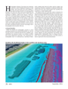
By 2020, the subsea sector of oil exploration and extraction is expected to account for 20% of total crude oil production. In addition, global marine ? sheries, which provide 15% of all animal protein consumed by humans, have been steadily collapsing for the last half century.
A Seamless Integration hydrographers interested in a more ef? cient and economical
Drone technology itself has progressed over the past decade, work? ow.
allowing aerial photographic observation to become more Esri has just released the Drone2Map for ArcGIS app, which accessible at a fraction of the cost of chartering aircraft for transforms high-resolution drone imagery into ready-to-use the same purpose. Fuel expenses alone can be an obstacle to aerial data in the GIS platform. Users can bring point-clouds, obtaining aerial data. Drone integration with geographic in- mosaic datasets, 3D meshes and orthomosaics directly into formation system (GIS) technologies has existed for several the platform in near real time without any third-party applica- years. Using drones has proved to be a cost-effective and safe tion. This is a huge leap in hydrographic technology because way to collect aerial data, with applications commonly used users can instantly produce new observations to update nauti- for ? ghting ? re, monitoring environmental changes and man- cal charts and topographic maps. Simple photographic data aging rights-of-way vegetation. However, when users bring obtained from a miniature camera mounted on a drone can be drone data into GIS, they exponentially increase the value of used for point-cloud collection, rather than rely on airborne that data. And thanks to new innovations in drone technology, lidar. Additionally, a geospatial platform stores and manages maritime users can exploit that integration in new and exciting Drone2Map data, provides authoring and publishing tools and ways. A seamless topobathymetric surface is now available to streams live and authoritative data for rich situational aware-
The Global Leader In Subsea Propulsion & Motion Control For Over 30 Years
Model 2020 115kgf forward 73 kgf reverse thrust
BRUSHLESS DC THRUSTERS • Customized to your specifcations • Self-contained electronics - 24 to 330VDC • Brushless DC motors for maximum performance & longevity • Aluminum, stainless steel or titanium construction options available • Magnetically coupled propellers eliminate shaft seals for greater reliability ™
BUILT IN THE USA www.tecnadyne.com
THE LEADER IN SUBSEA PROPULSION www.marinetechnologynews.com
Marine Technology Reporter 27
MTR #7 (18-33).indd 27 8/24/2016 12:24:25 PM