
New ‘Eyes’ on the Prize
Tappan Zee Constructors ‘See’ Below Hudson River with Trimble Marine Construction Systems and Teledyne Marine Imaging.
Since 1955, the Tappan Zee Bridge has been a critical thoroughfare for New Yorkers commuting between Rockland and Westchester Counties, located approximately 20 miles north of Manhattan and across the Hudson River from each other. However, a heavy increase in traffic and exponentially increasing maintenance costs ultimately lead to the decision to replace the historic bridge. The new Governor Mario M. Cuomo Bridge, the longest crossing in the New York State Thruway system, is designed to meet the needs of the future while supporting economic growth.
In 2013, Tappan Zee Constructors was contracted to design and build the twin-span crossing. The north span of the bridge officially opened to westbound traffic in August 2017, and the eastbound span was completed in September 2018. Tappan Zee Constructors began deconstructing the old bridge in 2017 – work that continues in 2019.
The new structure is already a landmark, featuring a 3.1-mile twin span cable-stayed structure. The bridge’s angled main span towers make it visually striking from all angles. When fully completed, it will include eight general traffic lanes, four emergency shoulders, a shared bike / pedestrian path and state-of-the-art traffic monitoring systems. Also unique is that the bridge has been designed and constructed to be mass-transit ready and can accommodate commuter rail.
Marine & environmental challenges
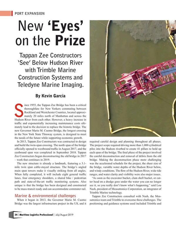
When it began in 2013, the Governor Mario M. Cuomo Bridge was the largest infrastructure project in the US, and it required careful design and planning throughout all phases. The project scope required driving more than 1,000 cylindrical piles into the Hudson riverbed to create 41 pillars to hold up each span of the bridge. The final phase of the project involved the careful deconstruction and removal of debris from the old bridge. Making the deconstruction phase more challenging was the accelerated schedule for the project, the sheer size of the bridge, variable water depths of the Hudson River below, and windy conditions. The flow of the Hudson River, wide tide ranges, and water clarity and visibility were also major issues.
“As soon as the excavator bucket, clam shell bucket, or cutter head on a dredge goes under the water you can no longer see it, so you really don’t know what’s happening,” said Lou Nash, president of Measutronics Corporation, an integrator of Trimble Marine technology.
Tappan Zee Constructors consulted with Nash, the Measutronics team and Trimble to overcome these challenges. The positioning and guidance systems used included Trimble and Teledyne components – Trimble software, hardware, and sensors for positioning, guidance and tracking of machines, and Teledyne marine imaging sonar for subsurface applications.
Eliminating unknowns: real-world conditions vs. ‘the plan’
Trimble Marine Construction software was used across the project for excavation, placement of structures and demolition work. Heavy equipment used included excavators, clam shell cranes, cutter head on a dredge and more. Regardless of the tool being used with the machine – buckets, pincers, shears, hammers, jackhammers – using the marine software and sonar equipment each had precise guidance, giving operators clarity and visibility to work.
Blake Yaffee, area manager for the project’s demolition portion, explains that his team started by using the system to establish a baseline of conditions in the river. This began with 3D point cloud data collection of submerged features via a survey vessel using sonar.
“We’re able to look at the structure beforehand and then take that imagery, evaluate and confirm elevations, quantities and conditions,” said Yaffee. “We were able to deal with any items that might create issues in advance of performing any actual work on the structure.”
After a baseline was set, Tappan Zee Constructors then used TMC software and a Teledyne high resolution multibeam echosounder to create a plan for ‘breaking up’ the old bridge’s concrete structures into rubble, which could then be safely removed from the river bottom. Surface data was then provided to the various machine types for guidance in deconstructing the submerged structures.
“From our system, what the operator sees in the first phase is where the tool has been so that he’s getting proper coverage of the inner deconstruction process,” said Nash. “Once he feels he has reached a certain level that they want to start removing the materials, the sonar comes in and maps out the debris so it’s able to track the tool as he’s doing a deconstruction and he’s able to provide guidance to the machines that have to remove the debris.”
A ‘bird’s eye view’ with pinpoint accuracy
Andrew Teese, a machine operator on the project, says the positioning equipment has been a significant advancement compared to conventional ‘hunting and pecking’ required for this type of marine construction work. Using traditional methods, a crew would likely excavate in a grid-like pattern in the general location of the old pier, from one end to the other. Instead, he was able to use the Trimble system on a Manitowoc 999 crawler crane with a clamshell tool to clean up the bottom of the river where the old pier was dismantled.
The software follows a ‘traffic light-like’ pattern, indicated in green on the operator’s control box when excavation is needed and changing to yellow as the operator gets closer to grade. The system provides updated information so as the structure is ‘broken up’ and moved under the water, the images and colors are updated in real time. On the screen, Trimble’s TMC software shows elevation, location, and a real-time 3D view. According to Teese, he has even been able to see and retrieve football-size pieces of concrete, which would have been nearly impossible to spot without sonar capabilities.
“It’s a lot faster because we can see where we have been, we can see how wide the material had spread and we can progress through the pier and the rubble pile with accuracy,” said Teese. “Things that you missed as you go through the area you can get a pinpoint location on, you don’t have to look around for things, you just know where everything is.”
With pinpoint imagery, including overlaid reference points and coordinates on top of the survey, the team then drew prisms around those ‘missing’ pieces of material and imported that data into operators’ control boxes.
“Anybody that has performed water demolition is very familiar with the term ‘working in the blind’ because that’s basically what people do,” said Yaffee. “For us, the investment in the product against the scale of the project, together with the fact that the sonar and the software can be reconfigured and used on the next project, made it very easy for us to make the decision to bring this equipment on.”
Focus: Safety and the Environment
In addition to quickly identifying and removing debris underwater, precise positioning has helped Tappan Zee Constructors break up difficult components and material underwater, without relying solely on divers. Divers also have a more predictable and well-documented plan before they go underwater to work, which improves diver safety.
“Cutting steel piles with excavator mounted shears without either the support of a diver or spending a significant amount of time just feeling around is nearly impossible,” said Yaffee. “With this level of visibility and positioning we are certainly able to review the conditions with the divers before they go under.”
Scanning the river bottom, the team also identified eroded structures, components and materials that had collected over the years from the old bridge. Tappan Zee Constructors recorded these scans and was asked by the New York State Thruway to remove the material. As a result, the site was returned to the state of New York in a more pristine condition then when they started work.
Yaffee believes that the technology has also allowed the team to carefully evaluate and document project progress. The tool’s real-time as-building capabilities provide daily insight into productivity and documentation that benchmarks were being met. Once tasks were completed, the team collected images of the area and identified any follow-on work that needed to be done.
Following this new workflow, Yaffee explains his team’s work has been safer, faster and more accurate. Not only that; the extended team can’t imagine going back to conventional methods.
“We no longer go through an evaluation process that we did initially to determine if it’s worth the investment, if there’s going to be a return on investment of bringing this equipment on,” said Yaffee. “In other words, it’s not going to make financial sense for us to have a piece of equipment out here that’s ‘blind’ while all the other pieces of equipment ‘have eyes’.”
Kevin Garcia is business area manager for marine and specialty construction in Trimble’s Civil Engineering and Construction Division. He has more than 15 years of experience in specialty construction and can be reached at [email protected].
This article first appeared in the 2019 JULY/AUG print edition of Maritime Logistics Professional magazine.
Read New ‘Eyes’ on the Prize in Pdf, Flash or Html5 edition of Jul/Aug 2019 Maritime Logistics Professional
Other stories from Jul/Aug 2019 issue
Content
- CYBER SECURITY: Are You Cyber Safe? page: 12
- Trust and Independence: page: 14
- PORT PROFILE: Big Baltimore page: 22
- BREAKBULK SHIPPING: Breakbulk Breaks the Mold page: 28
- New ‘Eyes’ on the Prize page: 34
- Transforming Today’s Transportation Terminal for Tomorrow’s Technology page: 44