GMDSS Historic Change In Maritime Safety Communications
One of the biggest changes in maritime safety communications since the invention of radio began to unfold last month.
Fueled by dramatic advances in mobile satellite and radio communications technologies and automatic distress alerting techniques, a new set of regulations for safety at sea took effect on February 1, 1992.
Known as the Global Maritime D i s t r e s s and Safety System (GMDSS), and introduced under t h e auspices of t h e International Maritime Organization (IMO), the new system enables coordinated search and rescue operations without delay.
A primary aim of GMDSS is to provide improved communications facilities to alert search and rescue authorities on shore, for better coordination of search and rescue efforts possibly using assistance from shipping in t h e vicinity of t h e emergency.
GMDSS also provides for t h e broadcast of maritime safety information, including navigational and meteorological warnings.
GMDSS applies to all p a s s e n g e r ships and cargo ships of 300 gross tons and over making int e r n a t i o n a l voyages.
These ships have seven years to fit t h e communications equipment, the specification of which varies, depending on t h e area where t h e ship operates.
GMDSS divides the seas into four different zones: SEA A r e a Al: An area, u s u a l l y w i t h i n 20-30 miles from land, within the range of shore-based VHF radio having digital selective calling (DSC) capability. (DSC is the technique used for automating calling for terrestrial services: MF, HF, and VHF).
SEA A r e a A2: An area excluding Al but within t h e range of shore-based MF radio (about 100 miles from shore) having DSC capability.
SEA A r e a A3: An area excluding Al and A2 but within t h e range of services provided by the Inmarsat geostationary satellite system which covers t h e whole globe except small areas of navigable water in t h e polar regions.
SEA A r e a A4: All other areas outside areas Al, A2, and A3.
The IMO has defined nine principal communications functions which need to be performed by all ships and then specified the equipment that would meet these requirements in each sea area. These are: • Ship-to-shore distress alerting; • Shore-to-ship distress alerting; • Ship-to-ship distress alerting; • Search and rescue coordination communications; • On-scene communications; • Transmitting and receiving locating signals; • Transmitting and receiving maritime safety information; • General radio communications; • Bridge-to-bridge communications.
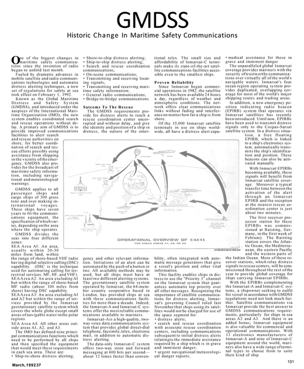
Satcoms To The Rescue The GMDSS requirements provide for distress alerts to reach a rescue coordination center uncorrupted and without delay, and give the identity and position of a ship in distress, the nature of the emer- gency and other relevant information.
Initiations of an alert can be automated by t h e push of a button or two. All available methods may be used, but all ships must have at least two different alerting systems.
The geostationary satellite system operated by Inmarsat, the 64-member country cooperative based in London, has provided ships at sea with these communications facilities for more t h a n a decade. Indeed, the Inmarsat-A and Inmarsat-C systems offer t h e most reliable communications available to mariners.
Inmarsat-Ais a high-quality, twoway voice data communications system t h a t provides global direct-dial telephone, facsimile, telex, electronic mail, in addition to automatic distress alerting.
The data-only Inmarsat-C system offers two-way store and forward messaging at 600 bits per second— about 12 times faster t h a n conventional telex. The small size and affordability of Inmarsat-C terminals make its state-of-the-art satellite communications facilities accessible even to the smallest ships.
Proven Reliability Since Inmarsat began commercial operations in 1982, the satellite network has been available 24 hours a day, regardless of weather and atmospheric conditions. The network offers clear communications links without fading and interference no matter how far a ship is from shore.
Of the 15,000 Inmarsat satellite terminals in use on ships worldwide, all have a distress alert capability, often integrated with automatic message generators that give a vessel's position and other vital information.
This facility enables ships in distress to use t h e "Priority 3" channel on t h e Inmarsat system t h a t guarantees automatic top priority over all other messages. Recognizing the importance of satellite communications for distress alerting, Inmarsat's governing Council ruled last November t h a t ships using its satellites would not be charged for use of the space segment for: • distress alerts; • search and rescue coordination with associate rescue coordination centers, including communications subsequent to initial distress alerts relatingto the immediate assistance required by a ship which is in grave and imminent danger; • urgent navigational/meteorological danger reports; • medical assistance for those in grave and imminent danger.
The unparalleled global Inmarsat coverage provides mariners with the security of trustworthy communications over virtually all of t h e world's navigable waters. Inmarsat's four ocean region operating system provides duplicated, overlapping coverage for most of the world's major shipping routes and trading areas.
In addition, a new emergency pos i t i on indicating radio beacon (EPIRB) system that operates via Inmarsat satellites has recently been introduced. Until now, EPIRBs have been used to transmit distress signals only to the Cospas-Sarsat satellite system. In a distress situation, a free floating EPIRB, which is linked to a ship's electronics system, automatically transmits t h e ship's identification and position. These beacons can also be activated manually.
With Inmarsat EPIRBs becoming available, these signals will benefit from Inmarsat satellite coverage.
Moreover a typical transfer time between the activation of the alert t h r o u g h an Inmarsat EPIRB and t h e reception at the nearest rescue coordination center is just about two minutes.
The first receiver processor station for these EPIRBs was commissioned at Raisting, Germany, in t h e first week of February. The Raisting station covers the Atlantic Ocean, t h e Mediterranean, the eastern Pacific and the western parts of the Indian Ocean. More of these receiver stations, which relay distress signals to rescue centers, will be commissioned throughout t h e rest of t h e year to provide global coverage for ships carrying Inmarsat EPIRBs.
With the EPIRBs complementing the Inmarsat-A and Inmarsat-C systems, a shipowner seeking to outfit his vessel in accordance with GMDSS regulations need not look much further.
Satellite communications via Inmarsat provide the best answer to GMDSS communications requirements, particularly for ships in sea areas A2 and A3. And there is an added bonus; Inmarsat equipment is also valuable for commercial and operational communications. With 13 electronics manufacturers of Inmarsat-A and nine of Inmarsat-C equipment around the world, mariners also have a wide range of terminal types to choose from to suite their kind of ship.
Read GMDSS Historic Change In Maritime Safety Communications in Pdf, Flash or Html5 edition of March 1992 Maritime Reporter
Other stories from March 1992 issue
Content
- New Membrane Care Skid Introduced By Lifestream page: 6
- Atlas Wins $10.8 Million Contract For Main Galleys On Carnival Superliners page: 6
- Call For Papers ForASNE DDG-51 Technical Symposium page: 8
- ILU Asks Speed-Up In Use Of Electronic Claims Systems page: 8
- Southwest Marine Celebrates 15 Years Of 'Crafting Quality' page: 9
- Surge In Orders, Output Reported By Chinese Yards page: 9
- FELS Launches Second A.P. Moller Rig page: 9
- Tanker Supply, Demand Profitability To 1996 page: 10
- Bisso Completes Four-Year Bollinger Contract; Successfully Lifts USS Aquila PHM-4 page: 11
- Kirby Corp. Signs Agreement To Buy Sabine Towing page: 12
- McDermott Awarded Exxon Contract For Harmony And Heritage Installation page: 12
- United Ropeworks Offers Free Color Brochure On Trevira Polyester Rope page: 12
- AWO ANNUAL page: 13
- LEADING INLAND OPERATORS SPEAK OUT page: 16
- Construction & Repair Activity Up At Small And Medium Size Yards page: 18
- Canada's Largest OSRV Designed By MARCO page: 21
- P&O Orders First Superliner For British Cruise Market From Meyer Werft Shipyard page: 23
- MarAd Approves Application To Sell Cargo Vessels page: 24
- Alan C. McClure Associates Develops Line Of 36-Foot Workboats page: 24
- Inspection Crackdown Planned By Ship Insurers page: 29
- Ship Gaming, Consolidator Bonding Legislation Approved By House page: 29
- IMO Expected To Finalize Double Hull Rules page: 30
- Bulker Life Extension To Be Performed By Hyundai Mipo page: 30
- Oyster Contamination Prompts Publication Of Discharge Rules page: 30
- Lindenau Delivers Largest Double-Hull Tanker Under German Flag page: 31
- Luxury Tax Repeal Would Be Boost To Boat Builders page: 32
- Values For Secondhand Tankers Rise In Fourth Quarter Of 1991 page: 32
- Mid-Deck Design In Doubt, Afterliests At Navy Research Center page: 32
- Ports '92 Conference To Be Held July 20-22 In Seattle, Wash. page: 35
- Japan-U.S. Effort To Explore Offshore Desert Storm Plaque Presented To Peck & Hale For Outstanding Support page: 35
- Murphy Offers Free Brochures On Alarms, Controls, Switches page: 36
- MarAd Awards Funds To N.Y. Maritime For Simulator Purchase page: 36
- OUTSTANDING CRUISE SHIPS page: 37
- Secondary Control Used By Rexroth To Supply Shipboard Electricity page: 41
- Wijsmuller Acquires Management Contract For Russian Heavy-Lifters page: 42
- ASNE 6th Annual Naval Logistics Symposium page: 43
- Radio Holland Introduces New Kelvin Hughes Integrated Bridge System In New York page: 43
- Inland Rivers Ports & Terminals Sets Dates For Annual Conference page: 48
- Hagglunds Denison Announces Improvements In Hydraulic Pumps page: 48
- New Sulzer Forms New Subsidiary In The Netherlands page: 48
- McElroy Machine Completes 14 Winches For U.S. Navy page: 51
- Coast Guard Improves Inspection Program To Detect Unsafe Tankers page: 53
- Bender Inc. Introduces New Ground Fault Detection Technology page: 54
- Wooster Offers Complete Literature Package On Non-Slip Safety Products page: 54
- SCLR Adds Two More Dockside Availabilities At Port Canaveral Facilities page: 55
- GPS Plots The Future Of Navigation & Communications page: 57
- New Low Weight, Low Cost Modules Delivered For North Sea Rig page: 59
- Lindenau Tanker Series Receives Two Nominations For International Awards page: 60
- Esgard's 'Bio Kote' Protects And Is Environmentally, Ecologically Safe page: 60
- GMDSS Historic Change In Maritime Safety Communications page: 61
- NAVIGATION & COMMUNICATIONS page: 64
- Special Seaward Fendering Installation At St. Croix page: 73
- Harrington Metal Furnishes Specially Modified Nozzles For 'City of Pittsburgh' page: 74
- To Meet New Regulations, Metritape Introduces Deck Master Gaging System page: 74
- New Vessel Management Program Introduced By Watercom page: 77
- Two LNG Carriers Now In Layup To Be Reactivated page: 80
- Barracuda Technologies Expanding Its Services To United States page: 80
- Crowley Announces New Service To Curacao page: 82
- Kuhlautomat Berlin GmbH, The Experts For Marine Refrigerating Plants page: 82
- Jered Brown Brothers To Consolidate Operations In Brunswick, Georgia page: 82
- Liebherr-Werk Nenzing Of Austria Announces New CBW Litronic Deck Crane page: 84
- MAN B&W Diesel Engines Ordered For World's Most Powerful Containerships page: 84
- MTU North America Promotes Berg, Shock page: 85
- MARCO Delivers First Of Two Filterbelt Systems To Saudi ARAMCO page: 86
- Oregon Iron Works Building Two Explosives Disposal Craft For Navy page: 87
- Launching Of M /V Santa Victoria At Flender Werft For Ivaran Shipping page: 87
- Coast Guard's Oil Spill Committee Sets Schedule For New Meetings page: 88
- Trawler Conversion Completed By MARCO page: 88
- IMarE/RINA Joint Offshore Group International Conference Dates Set page: 88
- Tests Show Superior Fire Protection Of Hi-Fog System By Marioff page: 90
- NYC's New Floating Detention Facility Built By Avondale Industries Opens Up Space page: 91
- Coast Guard Study Reveals Double Hulls Will Raise Shipping Costs page: 96
- Vicmar's Advance Fuel Saving Technology For Diesel Engines page: 96
